
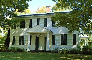
Bethlehem is a town in Albany County, New York, United States. The town's population was 35,034 at the 2020 census. Bethlehem is located immediately to the south of the city of Albany and includes the following hamlets: Delmar, Elsmere, Glenmont, North Bethlehem, Selkirk, Slingerlands, and South Bethlehem. U.S. Route 9W passes through the town. The town is named after the biblical Bethlehem. A notable person from this city is YouTuber James Charles.
Delmar is a hamlet in the Town of Bethlehem, in Albany County, New York, United States. It is a suburb of the neighboring city of Albany. The community is bisected by NY Route 443, a major thoroughfare, main street, and route to Albany.

Ravena is a village in Albany County, New York, United States. The population was 3,271 in the 2020 census an increase of 3 over the 2010 census. The village is in the southeast part of the town of Coeymans.

Coeymans is a town in Albany County, New York, United States. The population was 7,256 in the 2020 census, a decline from 7,418 at the 2010 census. The town is named after an early settler, who was the patent-holder for the area. The town is in the southeastern part of the county, south of Albany.
Mayfield is a town in Fulton County, New York, United States, northeast of Gloversville and Johnstown. The town contains a village also named Mayfield. The population of the town was 6,495 at the 2010 census.
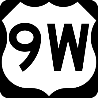
U.S. Route 9W (US 9W) is a north–south United States Numbered Highway in the states of New Jersey and New York. It begins in Fort Lee, New Jersey, as Fletcher Avenue crosses the US 1/9, US 46, and Interstate 95 (I-95) approaches to the George Washington Bridge, and heads north up the west side of the Hudson River to US 9 in Albany, New York. As its "W" suffix indicates, US 9W is a westerly alternate route of US 9 between the two locations. US 9W directly serves three cities—Newburgh, Kingston, and Albany—and enters the vicinity of several others. As the route heads north, it connects to several highways of regional importance, including I-84, US 209, New York State Route 23 (NY 23), and US 20. Much of US 9W parallels the New York State Thruway and NY 32; additionally, the latter overlaps with US 9W in four different locations.

Area codes 518 and 838 are telephone area codes in the North American Numbering Plan for eastern Upstate New York in the United States. 518 is one of the 86 original North American area codes created in 1947. Area code 838 was added to the 518 numbering plan area in 2017. The two area codes serve 24 counties and 1,200 ZIP Code areas in a numbering plan area (NPA) that extends from the eastern Mohawk Valley to the Vermont border, and from the Canada–US border to south of Albany. The bulk of the population is in the Capital District, the vicinity of the cities Albany, Schenectady, and Troy. Other cities in the NPA are Glens Falls, Plattsburgh, and Saratoga Springs. It includes the Upper Hudson Valley counties, Greene and Columbia counties, and some northern parts of Dutchess County.

New York State Route 55 (NY 55) is a 122.45-mile-long (197.06 km) east-west state highway in southern New York, running from the Pennsylvania state line at the Delaware River in Barryville to the Connecticut state line at Wingdale. It is the only other state highway beside NY 7 to completely cross the state, from border to border, in an east–west direction, although NY 17 does so and is partially east–west. It also forms a concurrency when it joins US 44 for 33 miles (53 km).
Guilderland Center is a hamlet in the town of Guilderland, Albany County, New York, United States. The hamlet lies along New York Route 146 and the Black Creek, a tributary of the Normans Kill.

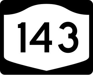
New York State Route 443 (NY 443) is an east–west state highway in the Capital District of New York in the United States. The route begins at an intersection with NY 30 in the town of Schoharie and ends 33.44 miles (53.82 km) later at a junction with U.S. Route 9W (US 9W) and US 20 in the city of Albany. It ascends the Helderberg Escarpment in the towns of Berne and New Scotland. Within the town of Bethlehem and the city of Albany, NY 443 is known as Delaware Avenue.

New York State Route 29 (NY 29) is a state highway extending for 94.79 miles (152.55 km) across the eastern portion of the U.S. state of New York. The western terminus of the route is at NY 28 and NY 169 in Middleville, Herkimer County. The eastern terminus of the route is at NY 22 just south of Salem, Washington County. NY 29 also serves the cities of Johnstown and Saratoga Springs and intersects four major north–south roadways: NY 10, NY 30, U.S. Route 9, and U.S. Route 4.

New York State Route 144 (NY 144) is a state highway in the Capital District of New York in the United States. The highway runs for 14.74 miles (23.72 km) as a two-lane road from an intersection with U.S. Route 9W (US 9W) in the Greene County town of New Baltimore to a junction with NY 32 in the town of Bethlehem just south of the Albany city limits. NY 144 closely parallels the New York State Thruway and the west bank of the Hudson River as it heads across Albany County. The Thruway and NY 144 connect at exit 22 about 6 miles (9.7 km) south of Albany in Bethlehem.
New York State Route 143 (NY 143) is a 18.82-mile-long (30.29 km) state highway in Albany County, New York, in the United States. The highway runs from an intersection with NY 85 in the town of Westerlo to a junction with NY 144 in the hamlet of Coeymans. The entire route is two lanes wide. NY 143 follows the path of the Coeymans and Westerlo Plank Road, a plank road that operated from 1850 to the early 20th century. The road became a state highway by 1915 and was designated NY 143 as part of the 1930 renumbering of state highways in New York.

New York State Route 396 (NY 396) is a 6.58-mile-long (10.59 km) east–west state highway in Albany County, New York, in the United States. The route is functionally a spur route as it connects to another signed state highway at only one end. The western terminus of NY 396 is at an intersection with County Route 103 (CR 103) in Callanans Corners, a small hamlet situated just south of the Bethlehem–Coeymans town line in the town of Coeymans. Its eastern terminus is at a junction with NY 144 in Bethlehem east of the hamlet of Selkirk. West of Callanans Corners, the road continues northwestward to NY 443 in New Scotland as CR 301. NY 396 was assigned as part of the 1930 renumbering of state highways in New York.
The Ravena-Coeymans-Selkirk Central Schools are located in Albany County, New York. There are four schools in the district: Albertus W. Becker Elementary, Pieter B. Coeymans Elementary, R.C.S. Middle School, and Ravena-Coeymans-Selkirk High School. Albertus W. Becker Elementary is located in Selkirk, Pieter B. Coeymans is located in Coeymans, and R.C.S. Middle School and R.C.S. High School are located in Ravena.
Alcove Reservoir is a reservoir located in Albany County, New York, United States. It serves as a water supply for the city of Albany. At 618 ft (188 m) in elevation, the closest hamlet is Alcove, part of the town of Coeymans. New York State Route 32 passes the reservoir on the west. It was built in 1928–1932, inundating the village of Indian Fields.
Feura Bush is a hamlet in the town of New Scotland, Albany County, New York, United States. It is in the southeastern corner of the town, along the Bethlehem town-line, eight miles south of Albany. The Feura Bush ZIP Code (12067) includes parts of the town of Bethlehem. It is in the Onesquethaw Volunteer Fire Company fire protection district. The 2020 Census showed 28 employer establishments in the hamlet.
South Bethlehem is a hamlet in the town of Bethlehem, Albany County, New York, United States. The hamlet sits on New York State Route 396 and lies southwest of the Selkirk Rail Yard and just north of the Coeymans town line.
Coeymans Hollow is a hamlet in Albany County, New York, United States. The community is located along New York State Route 143 4 miles (6.4 km) west of Ravena. Coeymans Hollow has a post office with ZIP code 12046.
New Baltimore is the primary hamlet in the town of New Baltimore, Greene County, New York, United States. It is a census-designated place (CDP), first listed as such prior to the 2020 census. The New Baltimore Hamlet Historic District occupies the historic core of the hamlet.


