Elsmere, New York

Last updated

Elsmere
Etymology: For Robert Elsmere, hero of Mrs. Humphry Ward's 1888 book titled Elsmere [1]
USA New York location map.svg
Red pog.svg
Elsmere
Location of Elsmere within the state of New York
Coordinates: 42°37′43″N73°49′0″W / 42.62861°N 73.81667°W / 42.62861; -73.81667
Country United States
State New York
Region Capital District
County Albany
Town Bethlehem
Settled1920s
Time zone UTC-5 (EST)
  Summer (DST) UTC-4 (EDT)
ZIP Code
12054
Area code 518

Elsmere is a hamlet of the town of the Bethlehem in Albany County, New York, United States. The hamlet is a suburb of the neighboring city of Albany. From the northeast to the southwest, it is bisected by New York Route 443 (Delaware Avenue), which is also the hamlet's main street and a major commuter route into Albany. Delaware Avenue is also home to most of the office and retail locations in Elsmere, including the largest such location: Delaware Plaza.

Contents

Elsmere does not have its own Post Office nor Zip Code, instead sharing with neighboring hamlet of Delmar. All locations in Elsmere use Delmar 12054 as the official address city and Zip Code.

History

Elsmere is situated along Delaware Avenue (State Route 443), formerly known as Delaware Turnpike. Suburban residential growth began to displace the rural farmland starting in 1928 when the Delaware Avenue Bridge opened across the Normans Kill; the bridge connected Elsmere directly to Albany. Prior to this, commuters to Albany used narrow, winding roads through Normansville and a smaller lower bridge. [2] The original center of the hamlet was the intersection of Elsmere Avenue and Delaware Avenue. By 1993, Delaware Avenue from the bridge over the Normans Kill to the abandoned railroad bridge marking Elsmere's unofficial border with Delmar had become heavily commercialized. Many of the businesses along Delaware Avenue occupied houses that had been converted to commercial use. Delaware Plaza, built in 1955, is the unofficial "center" of the hamlet of Elsmere. [1]

Education

Elsmere is located with the Bethlehem Central School District, which consistently receives local and national recognition for excellence. Elsmere Elementary is located within the hamlet on Delaware Ave just East of Elsmere Ave. Transportation is provided by the Bethlehem Central School District Student Transportation Department. BCSD students residing in Elsmere attend the following schools:

BCSD Athletics is part of The New York State Public High School Athletic Association (NYSPHSAA) Section 2 - Capital District in the Suburban Council.

Elsmere is served by the Bethlehem Public Library located in Delmar.

Emergency Services

Law Enforcement

Elsmere is served by the Town of Bethlehem Police Department.

Additional LE services are provided by Albany County Sheriff Office, New York State Police Troop G, and the FBI - Albany Office.

Ambulance

Elsmere is served by Delmar-Bethlehem EMS, in cooperation with Albany County Sheriff Office EMS Unit.

Fire Department

Elsmere is served by the Elsmere Fire District and Elsmere Fire Company A, Inc. The Fire District/Fire Company relationship is a joint and mutual effort toward a common goal: the protection of life and property.

Elsmere Fire District

Municipal Organization organized in 1928 for the purpose of providing the community fire protection, saving lives & property, suppress & control fires, fire prevention & education, support EMS activities, hazardous materials response, public assistance, and a safe working environment for Elsmere Fire Company A, Inc. EFD is responsible for the administration of taxpayer’s funds for fire suppression and prevention programs.

The Elsmere Fire District has two stations:

  • Headquarters: Located at 15 West Poplar Drive, Delmar, NY 12054
  • South Station: Located at 578 Feura Bush Rd, Glenmont, NY 12077

Elsmere Fire Company A, Inc

Formed in June 1922, EFC is the volunteer-based fire fighting force of the Elsmere Fire District. Membership includes 80 firefighters and social memberships numbering well over 200. EFC is a fraternal organization appointed by the Fire District to physically carry out the goals of the EFD.

EFC has a NYSFD drill team known as the Elsmere Wanderers, composed of active members of the Elsmere Fire Company, that competes in firematic competitions throughout the state. Events include both motorized and foot races, which utilize many aspects of everyday firefighting skills.

Transportation

Roads

Interstate Highways

  • Interstate 87: Part of the New York State Thruway, I-87 passes through the hamlet Northeast corner between the US-9W/ NY-32 overpass and the Town of Bethlehem- City of Albany border at Normans Kill. The nearest Thruway access is at Exit 23 in the City of Albany just North of Normans Kill.

Federal Routes

  • US Route 9W: The hamlet eastern border runs along US Route 9W between The Town of Bethlehem- City of Albany border at Normans Kill to Beacon Rd.

State Routes

  • NY Route 32: Known as Delmar Bypass, From interchange with US-9W at Eastern limits to the Western limits with Delmar hamlet about halfway between NY-335 (Elsmere Ave) and Murray Ave.
  • NY Route 335: Known as Elsmere Ave, run from intersection with Delaware Ave (NY-443) at Northern Terminus to Feura Bush Rd (NY-910A) at Southern Terminus.
  • NY Route 443: Known as Delaware Ave, this is considered Bethlehem's "Main St", running between the Town of Bethlehem - City of Albany border at the bridge over Normans Kill in the Normansville Neighborhood to the former D&H Railroad overpass that now carries the Albany County Helderberg-Hudson Rail Trail forming border with the hamlet of Delmar.
  • NY Route 910A: Known as Feura Bush Rd, an unsigned NYS Reference Route and former alignment of NY-32, runs from Dowers Kill to the West to the traffic circle intersection with US-9W in Bethlehem Center to the East.

County Routes

  • There are no Albany County routes located within the hamlet.

Important Town Roads

  • Wemple Rd: Feura Bush Rd (NY-910A) to Beacon Rd
  • Kenwood Ave: Oakwood Pl to Delmar Bypass (NY-32)
  • Bender Ln: Elsmere Ave (NY-335) to US-9W
  • Beacon Rd: Wemple Rd to US-9W

Airports

Buses

Elsmere is served by the Capital District Transit Authority (CDTA). All buses are equipped with bike racks and can accommodate two wheelchairs. The following routes serve Elsmere directly or nearby:

Railroad

Current

There is no passenger rail station that serves the hamlet directly. The nearest passenger rail station is the Joseph L. Bruno Rail Station in Rensselaer served by Amtrak.

Historic

Elsmere used to have passenger rail service provided by the Albany & Susquehanna Railroad, taken over by Delaware & Hudson Railroad. The A&S Railroad first came through Elsmere in 1863. In 1873, the A&S railroad line was leased to the Delaware & Hudson Railway and by July 1945, A&S was merged into the D&H Railroad. The Elsmere station was built in 1899 per D&H. Passenger service was discontinued in 1933 due to the increasing popularity of personal automobiles combined with frequent bus service between Elsmere and Albany. Freight service continued on the line through Elsmere through the early 1990's. In 1991, D&H was purchased by Canadian Pacific Railway. In 2003, CP proposed abandoning the 9.8 mile line between Voorheesville and Albany. In 2009, Albany County filed a railbanking application and purchased the Right-of-Way, transforming the entire length of the line into the Albany County Helderberg-Hudson Rail Trail, a multi-use recreational trail. Remnants of the Elsmere train station can be seen today, traveling South on Elsmere Ave under the rail trail overpass, on the left side is a set of concrete stairs that used to lead to the station. The D&H logo can be faintly seen on the overpass as well.

Location

Related Research Articles

<span class="mw-page-title-main">Bethlehem, New York</span> Town in New York, United States

Bethlehem is a town in Albany County, New York, United States. The town's population was 35,034 at the 2020 census. Bethlehem is located immediately to the south of the city of Albany and includes the following hamlets: Delmar, Elsmere, Glenmont, North Bethlehem, Selkirk, Slingerlands, and South Bethlehem. U.S. Route 9W passes through the town. The town is named after the biblical Bethlehem.

Delmar is a hamlet in the Town of Bethlehem, in Albany County, New York, United States. It is a suburb of the neighboring city of Albany. The community is bisected by NY Route 443, a major thoroughfare, main street, and route to Albany.

<span class="mw-page-title-main">Voorheesville, New York</span> Village in New York, United States

Voorheesville is a village within the town of New Scotland in Albany County, New York, United States. It is a suburb of Albany and part of the city's historic metropolitan area. The population was 2,841 at the 2020 census. The village is named after a railroad attorney, Alonzo B. Voorhees.

<span class="mw-page-title-main">New York State Route 32</span> North-south highway in New Yorks Hudson Valley

New York State Route 32 (NY 32) is a north–south state highway that extends for 176.73 miles (284.42 km) through the Hudson Valley and Capital District regions of the U.S. state of New York. It is a two-lane surface road for nearly its entire length, with few divided and no limited-access sections. From Harriman to Albany, it is closely parallel to Interstate 87 (I-87) and U.S. Route 9W (US 9W), overlapping with the latter in several places.

<span class="mw-page-title-main">U.S. Route 9W</span> U.S. Numbered Highway in New York/New Jersey

U.S. Route 9W (US 9W) is a north–south United States Numbered Highway in the states of New Jersey and New York. It begins in Fort Lee, New Jersey, as Fletcher Avenue crosses the US 1/9, US 46, and Interstate 95 (I-95) approaches to the George Washington Bridge, and heads north up the west side of the Hudson River to US 9 in Albany, New York. As its "W" suffix indicates, US 9W is a westerly alternate route of US 9 between the two locations. US 9W directly serves three cities—Newburgh, Kingston, and Albany—and enters the vicinity of several others. As the route heads north, it connects to several highways of regional importance, including I-84, US 209, New York State Route 23 (NY 23), and US 20. Much of US 9W parallels the New York State Thruway and NY 32; additionally, the latter overlaps with US 9W in four different locations.

<span class="mw-page-title-main">New York State Route 335</span> North–south state highway in New York, U.S.

New York State Route 335 (NY 335) is a north–south state highway located within the town of Bethlehem in Albany County, New York, in the United States. It extends for 1.77 miles (2.85 km) from an intersection with Feura Bush Road near the hamlet of Delmar to a junction with NY 443 in the hamlet of Elsmere. The two-lane route, named Elsmere Avenue, also has an intersection with NY 32 about halfway through the route. NY 335 was assigned to its current alignment in the 1930s.

Glenmont is a hamlet in the town of Bethlehem, Albany County, New York, United States. Glenmont is in the northeastern corner of the town and is a suburb of the neighboring city of Albany. It is bordered to the east by the Hudson River. Originally a farm town, today Glenmont is home to residential neighborhoods, a busy commercial corridor along Route 9W, and industry along the riverfront. It is part of the Bethlehem Central School District.

<span class="mw-page-title-main">New York State Route 85</span> State highway in Albany County, New York, US

New York State Route 85 (NY 85) is a state highway in Albany County, New York, in the United States. It is 26.49 miles (42.63 km) in length and runs from CR 353 in Rensselaerville to Interstate 90 (I-90) exit 4 in Albany. It also has a loop route, NY 85A, which connects NY 85 to the village of Voorheesville. The portion of NY 85 north of NY 140 to the Bethlehem–Albany town/city line is known as the Slingerlands Bypass. From there north to I-90, the road is a limited-access, four-lane highway named the Crosstown Arterial.

<span class="mw-page-title-main">New York State Route 443</span> State highway in New York, US

New York State Route 443 (NY 443) is an east–west state highway in the Capital District of New York in the United States. The route begins at an intersection with NY 30 in the town of Schoharie and ends 33.44 miles (53.82 km) later at a junction with U.S. Route 9W (US 9W) and US 20 in the city of Albany. It ascends the Helderberg Escarpment in the towns of Berne and New Scotland. Within the town of Bethlehem and the city of Albany, NY 443 is known as Delaware Avenue.

Slingerlands is a hamlet in the town of Bethlehem, Albany County, New York, United States. It is located immediately west of Delmar and near the New Scotland town-line and south of the Albany city-limits, and is thus a suburb of Albany. The Slingerlands ZIP Code (12159) includes parts of the towns of New Scotland and Guilderland.

<span class="mw-page-title-main">New York State Route 144</span> State highway in New York, US

New York State Route 144 (NY 144) is a state highway in the Capital District of New York in the United States. The highway runs for 14.74 miles (23.72 km) as a two-lane road from an intersection with U.S. Route 9W (US 9W) in the Greene County town of New Baltimore to a junction with NY 32 in the town of Bethlehem just south of the Albany city limits. NY 144 closely parallels the New York State Thruway and the west bank of the Hudson River as it heads across Albany County. The Thruway and NY 144 connect at exit 22 about 6 miles (9.7 km) south of Albany in Bethlehem.

<span class="mw-page-title-main">New York State Route 140</span> State highway in Albany County, New York, US

New York State Route 140 (NY 140) is an east–west state highway located entirely within the town of Bethlehem in Albany County, New York, in the United States. The highway runs for 2.07 miles (3.33 km) from a roundabout with NY 85 near the hamlet of Slingerlands to an intersection with NY 443 in the hamlet of Delmar. The first mile (1.6 km) of the route is a four-lane divided highway named Cherry Avenue Extension, while the second mile follows a two-lane street known as Kenwood Avenue. NY 140 initially followed Kenwood Avenue from the center of Slingerlands to Delmar when it was assigned in the mid-1930s; however, the route was altered to bypass Slingerlands in the mid-1970s.

<span class="mw-page-title-main">New York State Route 396</span> State highway in Albany County, New York, US

New York State Route 396 (NY 396) is a 6.58-mile-long (10.59 km) east–west state highway in Albany County, New York, in the United States. The route is functionally a spur route as it connects to another signed state highway at only one end. The western terminus of NY 396 is at an intersection with County Route 103 (CR 103) in Callanans Corners, a small hamlet situated just south of the Bethlehem–Coeymans town line in the town of Coeymans. Its eastern terminus is at a junction with NY 144 in Bethlehem east of the hamlet of Selkirk. West of Callanans Corners, the road continues northwestward to NY 443 in New Scotland as CR 301. NY 396 was assigned as part of the 1930 renumbering of state highways in New York.

Feura Bush is a hamlet in the town of New Scotland, Albany County, New York, United States. It is in the southeastern corner of the town, along the Bethlehem town-line, eight miles south of Albany. The Feura Bush ZIP Code (12067) includes parts of the town of Bethlehem. It is in the Onesquethaw Volunteer Fire Company fire protection district. The 2020 Census showed 28 employer establishments in the hamlet.
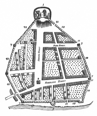
<span class="mw-page-title-main">Streets of Albany, New York</span> Streets of Albany, New York

The streets of Albany, New York have had a long history going back almost 400 years. Many of the streets have changed names over the course of time, some have changed names many times. Some streets no longer exist, others have changed course. Some roads existed only on paper. The oldest streets were haphazardly laid out with no overall plan until Simeon De Witt's 1794 street grid plan. The plan had two grids, one west of Eagle Street and the old stockade, and another for the Pastures District south of the old stockade.

Normansville is a former hamlet in Albany County, New York, United States. In the 19th century, Normansville was a hamlet in the town of Bethlehem. Normansville was located within and along the north and south banks of the ravine carved by the Normans Kill Creek, a tributary of the Hudson River.

Kenwood was a hamlet in the Town of Bethlehem, New York. The hamlet spanned both sides of the Normans Kill near the area where the Normans Kill flows into the Hudson River. In 1870, and again in 1910, northern portions of Kenwood were annexed by the City of Albany, New York.

South Bethlehem is a hamlet in the town of Bethlehem, Albany County, New York, United States. The hamlet sits on New York State Route 396 and lies southwest of the Selkirk Rail Yard and just north of the Coeymans town line.

Clarksville is a hamlet in the town of New Scotland, Albany County, New York, United States. It is situated along Delaware Turnpike in the southern part of the town at the foot of the Helderberg Escarpment. It is the site of the Clarksville Cave and has an annual Clarksville Heritage Day and Car Show. It is in the Onesquethaw Volunteer Fire Company fire protection district.

Bethlehem Center, also known as Babcock's Corners or Bethlehem Centre, is a hamlet in the Town of Bethlehem in Albany County, New York. It is located at the junction of U.S. Route 9W (US 9W) and New York State Route 910A (NY 910A) also known as Feura Bush Road / Glenmont Road.

References

  1. 1 2 Frances Ingraham (January 24, 1993). "The Suburban, Residential Hamlet of Elsmere". Albany Times Union. p. G1. Retrieved February 26, 2010.[ permanent dead link ]
  2. Rick Karlin (April 18, 1993). "A Bridge Moves Over Atop Tiny Normansville". p. H1. Retrieved February 27, 2010.[ permanent dead link ]