Wayne County is less than 50 miles west of Syracuse. Wayne County has been considered to be part of the Rochester, New York metropolitan area and lies on the south shore of Lake Ontario, forming part of the northern border of the United States with Canada.
Its location during the early westward expansion of the United States, on an international border and in a fertile farming region, has contributed to a rich cultural and economic history. Two world religions sprung from within its borders, and its inhabitants played important roles in abolitionism in the years leading up to the American Civil War. Nineteenth century War of 1812 skirmishes, Great Lakessailing ship commerce and Erie Canalbarge traffic have yielded to contemporary recognition as one of the world's most productive fruit growing regions. Wayne County ranks as New York's top apple producing county.
History
Prior to the arrival of Europeans, the land Wayne County encompasses was originally part of the Iroquois Confederacy, which had existed from around August 31, 1142.[3] When counties were established in New York State on November 1, 1683, it became part of Albany County.[4] Prior to its establishment, the territory that became Wayne County passed through successive administrative jurisdictions including Montgomery County (formed from Albany County in 1772), Ontario County (1789), and Seneca County (1804).[5]
On April 11, 1823, Wayne County was formed by combining portions of Seneca and Ontario counties. The county was formed from the towns of Wolcott and Galen in Seneca County, and Lyons, Sodus, Williamson, Ontario, Palmyra, and Macedon in Ontario County. The first election for county officers was held on May 6, 1823, and the first court convened later that month in Lyons.[6]
The first meeting of the county Board of Supervisors was directed to be held in October 1823 at the house of Henry L. Woolsey in Lyons. John S. Tallmadge served as the county’s first Surrogate and presided over its earliest court proceedings.[7]
The first westward road was one coming from near Utica to Geneva, and, with the building of the Cayuga Bridge in 1800, was the road chosen by nearly all of the westward travelers. This highway left the future Wayne County region somewhat isolated and settlers desiring to locate there came by way of streams and lakes lying to the north of the road. It was only a few years after that the "new road" came west, passing through the county, opening up the fertile Ganargua lands to easier settlement.[9]
The first permanent settlement was started by John Swift and Col. John Jenkins in March 1789, about two miles (3.2km) from Palmyra. In May of that year a small colony made up of the Stansell and Featherly families located at the junction of Ganargwa and the Canandaigua Outlet, calling the place Lyons, from a "fancied likeness of that city's location on the Rhone".[9]
While Phelps and Gorham sold some land to settlers, they were unable to make payments on their land and much of the land in the Phelps Gorham purchase either reverted to Massachusetts and was resold or conveyed directly to Robert Morris, a major financier of the Revolutionary War and signer of the US Declaration of Independence. In 1792, he in turn sold approximately 1,200,000 acres (4,900km2) to The Pulteney Association owned by Sir William Pulteney and two other minor partners. The Pulteney Purchase, or the Genesee Tract as it was also known, comprised all of the present-day counties of Ontario, Steuben and Yates, as well as portions of Allegany, Livingston, Monroe, Schuyler and Wayne. After Pulteney's death in 1805 the land was known as the Pulteney Estate.[10]
Sir William Pulteney selected Charles Williamson as land agent to develop the purchased 1,200,000 acres (4,900km2). In 1792, Williamson, a Scotsman, came to the unsettled wilderness in upstate New York to develop the land by building roads, selecting sites for towns, dividing land into lots, and building gristmills, taverns, stores and houses.[10] Williamson selected Sodus Bay on Lake Ontario as the point for a future commercial center, with the idea that the lake and the Saint Lawrence River would be the outlet for the products of the region. In 1794 he had roads built from Palmyra to Phelpstown (present-day Phelps). Sodus was surveyed by Joseph Colt in lots of a quarter acre (1,000 m2), a hotel was built, and $20,000 was expended in the first two years in improvements. Sodus quickly passed from having an uncertain future to the head of the towns of the region.[9]
War of 1812
Wayne County had been established only nine years before the War of 1812, and its civic and military institutions were still in an early stage of development when hostilities began along the Lake Ontario frontier.[11] The county formed part of the northern theater of the war, where control of Lake Ontario was contested by American and British naval forces.[12]
Because of its shoreline and access to Sodus Bay, the region was vulnerable to naval raids. Local defense relied primarily on militia units drawn from Wayne and neighboring counties, as regular U.S. Army forces were concentrated at larger posts such as Sackett’s Harbor and Oswego.[11]
Two skirmishes occurred within present-day Wayne County during the conflict. In June 1813, British forces conducted a raid at Sodus Bay.[11] A year later, in May 1814, British troops under the command of Commodore Sir James Lucas Yeo landed in the hamlet of Pultneyville in the town of Williamson.[13] Yeo’s squadron had previously raided Oswego to the east and had withdrawn from an unsuccessful engagement at Rochester before attempting to secure provisions from Pultneyville.
An agreement was initially reached with local residents allowing British forces to take supplies without resistance. A dispute followed, however, and an exchange of gunfire ensued, including cannon fire from British vessels positioned offshore in Lake Ontario.[11] Several residents were killed or wounded, and two were taken prisoner before British forces withdrew.
Although the engagements in Wayne County were limited in scale, they reflected the broader pattern of coastal raids and supply seizures that characterized the Lake Ontario campaign.[14] The raids contributed to local militia mobilization and heightened defensive measures along the shoreline during the final year of the war.
Great Lakes commerce
Until the opening of the Erie Canal in 1823, Pultneyville, New York, at the mouth of Salmon Creek, was Wayne County's only port. From about 1811 through the 1890s (when the customs office closed), shipping in this small hamlet extended to the Atlantic Ocean and the world via the Saint Lawrence River. During the early years of the 19th century, activity in Pultneyville focused on agricultural commerce from the surrounding region (as far south as Canandaigua) and the maritime trade on the Great Lakes. In 1865, it was home to nearly 30 lake captains, and many sailors from both Pultneyville and Sodus Bay crewed on whalers around the world.[15] In 1874 the first railroad appeared when the Lake Shore Railroad line opened and the center of trade moved three miles (4.8km) south to Williamson and Pultneyville's significance as a commerce center sharply declined.[16]
Religion: Wayne County and the Second Great Awakening
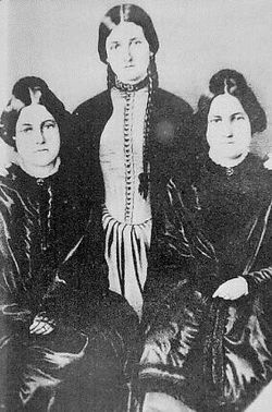
Kate and Margaret Fox
Wayne County played host to key events in the development of significant American religions during the country's Second Great Awakening period of the early 19th century. The Fox Sisters heard rappings from a dead peddler in Hydesville and spawned a movement that eventually garnered a million followers at its peak.[17]
Sodus Bay also was the site of a community of Shakers from 1826 to 1836. The site provided convenient access to travel by water on the Great Lakes Ontario and Erie, for visits to Shakers who lived in Ohio. This site might also have been useful for abolitionists moving former slaves to freedom in Canada via the Underground Railroad.
The first Shaker leadership team, Elders Jeremiah Talcott and Eldress Polly Lawrence, along with their assistants John Lockwood and Lucy Brown, came to Sodus from the Shakers' parent community at New Lebanon, New York. With 72 converts during their first year, they soon had 200 acres under cultivation. By 1835, the community had grown to almost 150.[19]
However, they learned in 1835 that a canal had been proposed to be dug through their land, and by New York state law, the canal company had the right to seize the property it chose. The Shakers responded by selling their land and 23 buildings to the canal company and moving inland to the 1,700 acres they purchased at Groveland, in Livingston County, New York. However, the canal was never built; two years later, the Shakers were asked to take their property back, but, having reestablished their village elsewhere, and knowing that the land could later be taken for the same purpose, they refused.[20]
Several diaries and journals describing the Shakers' early years at Sodus and Groveland can be found at the Western Reserve Historical Society, Cleveland, Ohio.[21] These manuscripts are available on microfilm at more than 20 locations throughout the U.S.[22]
Spiritualists often set March 31, 1848, as the beginning of their movement. On that date, Kate and Margaret Fox, of Hydesville, reported that they had made contact with the spirit of a murdered peddler. What made this an extraordinary event was that the spirit communicated through audible rapping noises, rather than simply appearing to a person in a trance. The evidence of the senses appealed to practical Americans, and the Fox sisters became a sensation. Demonstrations of mediumship (seances and automatic writing, for example) proved to be a profitable business, and soon became popular forms of entertainment and spiritual catharsis. The Foxes earned a living this way, as did many others.[23]
The Erie Canal transits the southern edge of the county. The villages of Clyde, Lyons, Newark, Palmyra and Macedon all became homes to canal locks when the Albany to Rochester section of the canal opened on September 10, 1823. On that day these communities became part of a direct water-link between the eastern seaboard metropolises of New York City and Baltimore and America's expanding western frontier.
Agriculture and the Fruit Belt
Following the opening of the Erie Canal in 1823, agriculture became the dominant economic activity in Wayne County.[28] Improved transportation reduced shipping costs and allowed farm products to reach eastern urban markets more efficiently.[29] The fertile glacial soils of the region, combined with the moderating climatic influence of Lake Ontario, encouraged commercial fruit cultivation along the county’s northern towns.[30]
By the mid-19th century, apple orchards, along with cherries, peaches, and pears, were being grown commercially in towns including Williamson, Ontario, and Sodus.[31] Railroad expansion in the mid- to late-19th century further stimulated agricultural growth by allowing perishable produce to reach markets more rapidly than canal transport alone.[32] Fruit packing houses, cold storage facilities, and cooperative marketing associations developed during this period to support orchard expansion.[33]
By the early 20th century, Wayne County ranked among the leading apple-producing counties in New York State, a position it has frequently maintained.[34] In addition to fruit cultivation, dairy farming, grain production, and vegetable growing remained significant components of the county’s rural economy throughout the 19th and early 20th centuries.[35]
Railroads and Industrial Development
Beginning in the 1850s, railroad lines supplemented canal traffic and gradually shifted commercial activity toward inland villages.[36] Communities such as Newark, Lyons, and Clyde developed small manufacturing centers that included flour mills, foundries, canning operations, and agricultural equipment production.[37]
The opening of the Lake Shore Railroad in 1874 reduced the commercial importance of smaller Lake Ontario ports such as Pultneyville as trade increasingly moved along rail corridors.[38] By the late 19th century, the county’s economy was primarily agricultural, supplemented by localized industrial activity.[39]
Twentieth-Century Developments
During the early 20th century, improvements in transportation, refrigeration, and mechanized farming further transformed the county’s agricultural economy.[40] Cooperative fruit marketing expanded, and commercial food processing operations became more prominent.[41]
Following World War II, mechanization reduced the number of small farms while increasing production efficiency.[42] Residential development expanded along major transportation corridors, including U.S. Route 104.[43] Tourism and recreational boating increased along Sodus Bay and the Lake Ontario shoreline during the mid-20th century.[44]
Late 20th and Early 21st Century
In the late 20th century, Wayne County remained heavily agricultural, particularly in apple production.[45]Agritourism, wineries, and farm markets became increasingly significant components of the local economy.[46] Elevated Lake Ontario water levels in 2017 and 2019 prompted renewed attention to shoreline management and flood mitigation efforts.[47]
Hoffman essays
Wayne County high school seniors are offered the opportunity to win a scholarship by The Augustus L. and Jennie D. Hoffman Foundation Scholarship Essay Program. Established in 1954 to encourage the study of local history, students research and write essays on some aspect of Wayne County history or civic affairs. Between its inception and 2007 over 600 essays have been submitted.[48]
The Ginna plant was the site of a minor nuclear accident when, on January 25, 1982, a small amount of radioactive steam leaked into the air after a steam-generator tube ruptured.[49][50] The leak which lasted 93 minutes led to the declaration of a site emergency. The rupture was caused by a small pie-pan-shaped object left in the steam generator during an outage. This was not the first time a tube rupture had occurred at an American reactor but following on so closely behind the Three Mile Island accident caused considerable attention to be focused on the incident at the Ginna plant. In total, 485.3 curies of noble gas and 1.15 millicuries of iodine-131 were released to the environment.[51]
Historical societies
In addition to the county historical society, there are a number of other historical preservation organizations. Most of these are town or village based.
Newark-Arcadia Historical Society
Butler Historical Preservation Society
Galen Historical Society
Historic Palmyra, Inc.
Lyons Heritage Society
Macedon Historical Society
Marion Historical Society
Ontario Historical & L.P. Society
Pultneyville Historical (please refer to Williamson-Pultneyville Historical Society)
Red Creek Historical Society
Rose Historical Society
Town of Sodus Historical Society
Sodus Bay Historical Society
Walworth Historical Society
Wayne County Historical Society
Williamson-Pultneyville Historical Society (www.w-phs.org)
Wolcott Historical Society
Law, government and politics
The county is governed by a Board of Supervisors, composed of the town supervisors from each of the county's fifteen towns. The board's chairman is selected from amongst the supervisors. The 2007 county budget was $154 million (~$224million in 2024).[52]
The county seat is the town of Lyons and bi-weekly board meetings are held in the Wayne County Court House in the hamlet. In August 2010, the board made history by convening outside of Lyons for the first time—at the Wayne County fairgrounds in Palmyra.[53]
The Wayne Supreme & County Court (7th Judicial District) sits in Lyons and hears felony cases as well as a few civil cases; the Wayne County Drug Treatment Court also provides an opportunity for recovering drug addicts to work with each other and improve their lifestyles.[54] Vehicle and traffic matters, small claims, evictions, civil matters and criminal offenses in Wayne County are heard in locally-funded town and village courts (collectively known as the Justice Courts).[55]
Politics
United States presidential election results for Wayne County, New York[56]
As of November 2013, Wayne County had a total of 56,589 voters registered (53,891 active, 2,698 inactive). Of those totals: 14,339 were registered as Democrats (13,574 active, 765 inactive); 23,144 as Republicans (22,338 active, 806 inactive); 3,035 as Independence (2,831 active, 204 inactive); 1,517 as Conservative (1,454 active, 63 inactive); and the rest as Greens, Libertarians, and other minor parties.[57] In the 2010 gubernatorial election, Wayne County cast 12,126 Democratic votes for Andrew M. Cuomo, 9,552 Republican votes for Carl Paladino, 1,153 Independence votes for Cuomo, 2,489 Conservative votes for Paladino, 490 Working Families Party votes for Cuomo, and 401 Taxpayers Party votes for Paladino.[58]
Wayne County has only voted for the Democratic presidential candidate once since the Republican Party was founded in 1854.
According to the U.S. Census Bureau, the county has a total area of 1,383 square miles (3,580km2), of which 604 square miles (1,560km2) is land and 779 square miles (2,020km2) (56%) is water.[60]
Wayne County is in the western part of New York State, east of Rochester and northwest of Syracuse, on the south shore of Lake Ontario. Sodus Bay is located on the north shoreline of the county. Wayne is bounded by five other New York counties: the northern boundary is Lake Ontario with Canada on the opposite shore; the western boundary is Monroe County; and the eastern boundary is Cayuga County; the south boundary is shared with Ontario and Seneca counties.
The Clinton Formation, a band of red hematite across the county, led to a thriving iron industry during the 19th century. Furnaces were located in the Towns of Ontario and Wolcott.
Wayne County is included in the Eastern Great Lakes and Hudson Lowlands ecoregion, which extends along the south shores of Lake Erie and Lake Ontario and the St. Lawrence River to Lake Champlain, and south down the Hudson River. This region was glaciated during the last ice age, and contains prominent glacial features including till and drumlins, as well as the valleys containing the Finger Lakes. Part of the area was covered by Glacial Lake Iroquois, while regions further to the east were flooded under the Champlain Sea. At one point during the melting of the glaciers, the Great Lakes drained down the Hudson River to the Atlantic Ocean.[61]
U.S. Decennial Census[64] 1790-1960[65] 1900-1990[66] 1990-2000[67] 2010-2020[1]
2020 census
Wayne County, New York – Racial and ethnic composition Note: the US Census treats Hispanic/Latino as an ethnic category. This table excludes Latinos from the racial categories and assigns them to a separate category. Hispanics/Latinos may be of any race.
As of the census of 2010, there were 93,772 people, 36,585 households, and 25,304 families residing in the county. The population density was 155 inhabitants per square mile (60/km2).[77]
There were 36,585 households, out of which 29.5% had children under the age of 18 living with them, 53.0% were married couples living together, 11.0% had a female householder with no husband present, and 30.8% were non-families. 24.5% of all households were made up of individuals, and 9.8% had someone living alone who was 65 years of age or older. The average household size was 2.53 and the average family size was 2.99.
In the county, the population was spread out, with 26.2% under the age of 20, 5.1% from 20 to 24, 23.8% from 25 to 44, 30.7% from 45 to 64, and 14.2% who were 65 years of age or older. The median age was 41.6 years. For every 100 females, there were 98.5 males. For every 100 females age 18 and over, there were 97.3 males.
The median income for a household in the county was $52,601, and the median income for a family was $62,677. Males had a median income of $47,056 versus $35,684 for females. The per capita income for the county was $25,327. About 7.8% of families and 11.3% of the population were below the poverty line, including 16.4% of those under age 18 and 6.9% of those age 65 or over.
There were 41,057 housing units at an average density of 68 unitsper square mile (26 units/km2). 10.9% of housing units were vacant.
There were 36,585 occupied housing units in the town. 28,106 were owner-occupied units (76.8%), while 8,479 were renter-occupied (23.2%). The homeowner vacancy rate was 1.5% of total units. The rental unit vacancy rate was 9.4%.[77]
Earlier demographic statistics
Families made up 70 percent of the households in Wayne County in 2005. This figure includes both married-couple families (59 percent) and other families (12 percent). Non-family households made up 30 percent of all households. Most of these households were people living alone, but some were composed of people living in households in which no one was related to the householder. Source: American Community Survey, 2005 18.0% were of German, 12.8% Italian, 12.6% English, 11.6% Dutch, 11.4% Irish and 8.9% American ancestry according to Census 2000. 95.7% spoke English as their first language, 2.2% Spanish, 1.8% spoke French and 0.2% spoke another language.
Economy
According to the Wayne County Industrial Development Agency, there are over 150 manufacturing firms in Wayne County, including several Fortune 500 companies located in the county based on market access, a modern transportation network, and favorable industrial conditions. These companies benefit from a skilled workforce including graduates from some of the colleges and universities located within an hour's drive of Wayne County including the University of Rochester, Cornell University, Colgate University and Syracuse University. From its location midway between Rochester and Syracuse, Wayne County is part of the Finger Lakes region (which includes Cayuga, Genesee, Livingston, Monroe, Ontario, Orleans, Seneca, Wayne, Wyoming, and Yates counties) whose businesses annually export an estimated $16 billion in goods.[79]
The Finger Lakes region made $1.2 billion (~$1.74billion in 2024) in agricultural sales in 2007, which represented 27.9 percent of the total farm sales in New York. In 2007, there were 6,417 farms and 1,500,000 acres (6,100km2) of farmland in the Finger Lakes. Wayne County was the State's top producer of fruits, tree nuts, and berries. Apples are a major crop in Wayne—the county was the State's top producer of apples and ranked third in the nation in 2007.[80]
The following quick facts apply to Wayne County businesses:
Total employer establishments, 2021 1,676
Total employment, 2021 19,136
Total employment, percent change 2020–2021 -6.0%
Total nonemployer establishments, 2021 5,023
All employer firms, reference year 2017 1,494
Men-owned employer firms, reference year 2017 990
Women-owned employer firms, reference year 2017 Suppressed; does not meet publication standards [sic]
Minority-owned employer firms, reference year 2017 69
Nonminority-owned employer firms, reference year 2017 1,249
Veteran-owned employer firms, reference year 2017 Suppressed
Nonveteran-owned employer firms, reference year 2017 1,191
Total health care and social assistance receipts/revenues, 2017 ($1000) 228,084
Total transportation and warehousing receipts/revenues, 2017 ($1000) 34,592
Total retail sales, 2017 ($1000) 997,103
Total retail sales per capita, 2017 $11,026
Total accommodation and foodservices sales, 2017 ($1000) 78,377
Wayne County does not have a single unified school district to deliver K-12 education, but multiple central school districts. Each district is governed by a locally-elected board of education, run by a hired superintendent, and funded largely through property taxes, as well as state and federal aid. These districts include:
As with all educational activities in New York State, Wayne County's school systems are ultimately answerable to the New York State Board of Regents and the New York State Education Department, as well as their local communities. These districts also participate in the Wayne Finger Lakes Board of Cooperative Educational Services (BOCES), a state-established organization which shares common educational resources and has its own elected board and superintendent.
Wayne County also has several private, parochial/religiously-based schools, including:
Wayne County is home to several festivals and parades, most from late spring through early fall due to the Upstate New York climate. Some of the more notable, listed in order of occurrence, include:
Pultneyville Homecoming Festivities Historic Hamlet of Pultneyville in Town of Williamson, Wayne County on Seaway Trail; www.w-phs.org (3rd weekend every July)
The Bog & Grog (Wallington, 1st Sunday after Mother's Day and 1st Sunday after Labor Day
Also, many of Wayne County's volunteer fire departments host "firemen's carnivals" throughout the summer, with parades, rides, food, fireworks, and attractions which become a centerpiece of the summer social circuit.
Communities
The county has no cities. There are 15 towns and seven villages.
↑"Find a County". National Association of Counties. Retrieved June 7, 2011.
↑Barbara, Mann; Jerry L. Fields (1997). "A Sign in the Sky: Dating the League of the Haudenosaunee". American Indian Culture and Research Journal. 21 (2). American Indian Studies Center.
↑Hitsman, J. Mackay (1999). The Incredible War of 1812. University of Toronto Press. ISBN9780802086290.{{cite book}}: Check |isbn= value: checksum (help)
↑Taylor, Alan (2010). The Civil War of 1812: American Citizens, British Subjects, Irish Rebels, and Indian Allies. Alfred A. Knopf. ISBN9780670025582.{{cite book}}: Check |isbn= value: checksum (help)
↑Roemer, Lillian (Spring 1996). The Whale Hunters of Pultneyville. Rochester, New York: Rochester Public Library. p.5.
↑The first train from Oswego to Charlotte, Rochester's port, ran on January 1, 1875. McKelvey, Blake (October 1968). Railroads in Rochester's History. Rochester, New York: Rochester Public Library. p.13.
↑Stephen J. Paterwic, Historical Dictionary of the Shakers (Lanham, Maryland: Scarecrow Press, 2008), 197.
↑Paterwic, Historical Dictionary of the Shakers, 197.
↑See, for instance: A Record of the commencement and progress of Believers at Sodus - and Portbay (1826-1833), ms. V:B-21; and a second volume (1826-1838), V:B-22, which includes a roster, both at Western Reserve Historical Society.
↑The current Shakers, who live at Sabbathday Lake, in New Gloucester, Maine, maintain a Shaker Library which owns this microfilm, as do many of the Shaker historical sites and a number of academic institutions.
↑"The Underground Railroad". The Hoffman Foundation Scholarship Essay Program. 1955.{{cite journal}}: Cite journal requires |journal= (help)
↑"The Road North". The Hoffman Foundation Scholarship Essay Program. 1970.{{cite journal}}: Cite journal requires |journal= (help)
↑"Williamson's Contribution to Three Great Movements". The Hoffman Foundation Scholarship Essay Program. 1977.{{cite journal}}: Cite journal requires |journal= (help)
↑Clark, Lewis H. (1883). Military History of Wayne County, N.Y.: The County in the Civil War. Sodus, N.Y.: Lewis H. Clark, Hulett & Gaylord.
↑Shaw, Ronald E. (1966). Erie Water West: A History of the Erie Canal, 1792–1854. University Press of Kentucky. ISBN9780813117150.{{cite book}}: Check |isbn= value: checksum (help)
↑Taylor, George Rogers (1951). The Transportation Revolution, 1815–1860. Rinehart & Company.
↑Clark, Lewis H. (1883). History of Wayne County, New York. Syracuse, New York: D. Mason & Co.
↑Clark, Lewis H. (1883). History of Wayne County, New York. Syracuse, New York: D. Mason & Co.
↑Stover, John F. (1997). American Railroads. University of Chicago Press. ISBN9780226776586.{{cite book}}: Check |isbn= value: checksum (help)
This page is based on this Wikipedia article Text is available under the CC BY-SA 4.0 license; additional terms may apply. Images, videos and audio are available under their respective licenses.