
Lake Ontario is one of the five Great Lakes of North America. It is bounded on the north, west, and southwest by the Canadian province of Ontario, and on the south and east by the U.S. state of New York. The Canada–United States border spans the centre of the lake.

The National Oceanic and Atmospheric Administration is an American scientific and regulatory agency charged with forecasting weather, monitoring oceanic and atmospheric conditions, charting the seas, conducting deep-sea exploration, and managing fishing and protection of marine mammals and endangered species in the US exclusive economic zone. The agency is part of the United States Department of Commerce and is headquartered in Silver Spring, Maryland.

The Channel Islands National Marine Sanctuary is a sanctuary off the coast of Santa Barbara and Ventura counties in Southern California 350 miles (563 km) south of San Francisco and 95 miles (153 km) north of Los Angeles. It was designated on October 2, 1980, by the National Oceanic and Atmospheric Administration and was expanded in 2007.
The National Ocean Service (NOS) is an office within the U.S. Department of Commerce, National Oceanic and Atmospheric Administration (NOAA). It is the responsible for preserving and enhancing the nation's coastal resources and ecosystems along approximately 95,000 miles (153,000 km) of shoreline, that is bordering 3,500,000 square miles (9,100,000 km2) of coastal, Great Lakes, and ocean waters. Its mission is to "provide science-based solutions through collaborative partnerships to address the evolving economic, environmental, and social pressures on our oceans and coasts." Its projects focus on working to ensure the safe and efficient marine transportation, promoting the protection of coastal communities, conserving marine and coastal places. NOS employs 1,700 scientists, natural resource managers, and specialists in many different fields. The National Ocean Service was previously also known as the National Ocean Survey until it was renamed in 1983.
A U.S. National Marine Sanctuary is a federally designated area within United States waters that protects areas of the marine environment with special conservation, recreational, ecological, historical, cultural, archeological, scientific, educational, or aesthetic qualities. The program was established in 1972 by the Marine Protection, Research, and Sanctuaries Act and is currently administered by the National Ocean Service through the National Marine Sanctuaries Act (NMSA).
Thunder Bay National Marine Sanctuary and Underwater Preserve is a United States National Marine Sanctuary on Lake Huron's Thunder Bay, within the northeastern region of the U.S. state of Michigan. It protects an estimated 116 historically significant shipwrecks ranging from nineteenth-century wooden side-wheeler paddle steamers to twentieth-century steel-hulled steamers. There are a great many wrecks in the sanctuary, and their preservation and protection is a concern for United States Government policymakers. The landward boundary of the sanctuary extends from the western boundary of Presque Isle County to the southern boundary of Alcona County. The sanctuary extends east from the lakeshore to the international border. Alpena is the largest city in the area.

The Papahānaumokuākea Marine National Monument (PMNM) is a World Heritage listed U.S. National Monument encompassing 583,000 square miles (1,510,000 km2) of ocean waters, including ten islands and atolls of the Northwestern Hawaiian Islands. It was created in June 2006 with 140,000 square miles (360,000 km2) and expanded in August 2016 by moving its border to the limit of the exclusive economic zone, making it one of the world's largest protected areas. It is internationally known for its cultural and natural values as follows:
The area has deep cosmological and traditional significance for living Native Hawaiian culture, as an ancestral environment, as an embodiment of the Hawaiian concept of kinship between people and the natural world, and as the place where it is believed that life originates and to where the spirits return after death. On two of the islands, Nihoa and Mokumanamana, there are archaeological remains relating to pre-European settlement and use. Much of the monument is made up of pelagic and deepwater habitats, with notable features such as seamounts and submerged banks, extensive coral reefs and lagoons.

James Preston Delgado is an American maritime archaeologist, historian, maritime preservation expert, author, television host, and explorer. Delgado is a maritime archaeologist with over four decades of experience in underwater exploration. He has participated in over 100 shipwreck investigations worldwide, including notable sites such as the RMS Titanic, USS Independence (CVL-22), USS Conestoga (AT-54), USS Monitor, USS Arizona (BB-39), USS Nevada (BB-36), Sub Marine Explorer, the buried Gold Rush ships of San Francisco, the atomic bomb test fleet at Bikini Atoll, the slave ship Clotilda, and Kublai Khan's lost fleet from the Mongol invasions of Japan.
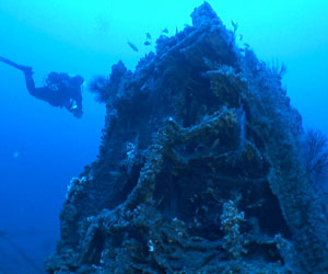
Monitor National Marine Sanctuary is the site of the wreck of the USS Monitor, one of the most famous shipwrecks in U.S. history. It was designated as the country's first national marine sanctuary on February 5, 1975, and is one of only two of the seventeen national marine sanctuaries created to protect a cultural resource rather than a natural resource. The sanctuary comprises a column of water 1 nautical mile in diameter extending from the ocean’s surface to the seabed around the wreck of the American Civil War ironclad warship, which lies 16 nautical miles south-southeast of Cape Hatteras, North Carolina. Average water depth in the sanctuary is 230 feet (70 m). Since it sank in 1862, Monitor has become an artificial reef attracting numerous fish species, including amberjack, black sea bass, oyster toadfish, and great barracuda.
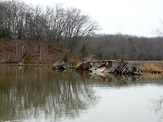
Mallows Bay is a small bay on the Maryland side of the Potomac River in Charles County, Maryland, United States. The bay is the location of what is regarded as the "largest shipwreck fleet in the Western Hemisphere" and is described as a "ship graveyard."

St. Peter is a historic Great Lakes schooner that sank in 1898 in Lake Ontario near Pultneyville in Wayne County, New York.

The Wisconsin Shipwreck Coast National Marine Sanctuary is a national marine sanctuary administered by the National Oceanic and Atmospheric Administration (NOAA), an agency of the United States Department of Commerce; NOAA co-manages the sanctuary jointly with the State of Wisconsin. It is located in Lake Michigan along the coast of Wisconsin. It was created in 2021 as the 15th national marine sanctuary and protects shipwrecks considered nationally important archaeological resources.

The Chumash Heritage National Marine Sanctuary is a National Marine Sanctuary in the Pacific Ocean off the coast of San Luis Obispo and Santa Barbara counties on the Central Coast of California. It was designated on October 11, 2024, by the National Oceanic and Atmospheric Administration (NOAA). It is the first marine sanctuary to have been proposed by an Indigenous group. It protects nationally significant natural, cultural, and historical resources in Central California's coastal and ocean waters and offers opportunities for research, community engagement, and education and outreach activities.

The Mallows Bay–Potomac River National Marine Sanctuary is a National Marine Sanctuary in the United States located in the Potomac River in Charles County, Maryland. It is best known for the "Ghost Fleet," 118 historic shipwrecks in Mallows Bay in the sanctuary's northeast corner which is the largest shipwreck fleet in the Western Hemisphere. They are among more than 200 shipwrecks in the sanctuary, some of which date as far back as the American Revolutionary War and others to the American Civil War.

The Looe Key National Marine Sanctuary was a National Marine Sanctuary in the waters in the Florida Keys in Florida in the United States that existed from 1981 to 1990. It protected Looe Key, a coral reef south of Big Pine Key. In 1990, it was subsumed by the new Florida Keys National Marine Sanctuary, which included its waters. However, it continued to operate until 1997, when it was fully integrated into the Florida Keys sanctuary.

The Key Largo National Marine Sanctuary was a National Marine Sanctuary in the waters in the Florida Keys in Florida in the United States that existed from 1975 to 1990. It was the second national marine sanctuary, and it protected the portion of a barrier reef beyond Florida state waters in John Pennekamp Coral Reef State Park. In 1990, it was subsumed by the new Florida Keys National Marine Sanctuary, which included its waters. However, it continued to operate until 1997, when it was fully integrated into the Florida Keys sanctuary.


