Eel Weir State Park is a 16-acre (0.065 km2) state park in St. Lawrence County, New York. The park is located in the St. Lawrence Valley on the Oswegatchie River approximately two miles (3.2 km) from Black Lake and approximately eight miles (13 km) southwest of Ogdensburg.
Four Mile Creek State Park is a 248-acre (1.00 km2) state park located in the Town of Porter in Niagara County, New York. The park is at the mouth of Four Mile Creek on the shore of Lake Ontario, approximately 15 miles (24 km) north of the Niagara Falls.
Hudson River Islands State Park is a 235-acre (0.95 km2) state park in New York. The park is located on the Hudson River in Greene and Columbia counties.

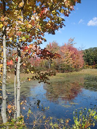
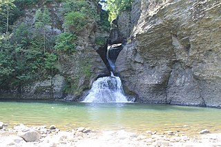
Chittenango Falls State Park is a 193-acre (0.78 km2) state park located in Madison County, New York, east of Cazenovia Lake. The park features a 167-foot (51 m) waterfall that cascades over roughly 400-million-year-old bedrock. At the bottom of the falls Chittenango Creek flows underneath a wooden bridge. The park offers a variety of activities including picnic tables with pavilions, a playground, a nature trail, hiking, and fishing.
Verona Beach State Park is a 1,735-acre (7.02 km2) state park located on the eastern shore of Oneida Lake in the Town of Verona, Oneida County, New York. The park is located on NY 13 northwest of the City of Oneida and south of Sylvan Beach. Oneida Creek enters the Oneida Lake south of the park.
Grass Point State Park is a 114-acre (0.46 km2) state park located in the Town of Orleans in Jefferson County, New York. The park is located along the St. Lawrence River by NY 12 and NY 180, between Clayton and Alexandria Bay.
Macomb Reservation State Park is a 600-acre (2.4 km2) state park in the Town of Schuyler Falls in Clinton County, New York, United States. The park is located on the Salmon River, outside the Adirondack Park, and two miles (3.2 km) west of the hamlet of Schuyler Falls.
Sunken Meadow State Park, also known as Governor Alfred E. Smith State Park, is a 1,287-acre (5.21 km2) state park located in the Town of Smithtown in Suffolk County, New York on the north shore of Long Island. The park, accessible via the Sunken Meadow State Parkway, contains the 27-hole Sunken Meadow State Park Golf Course.

Taughannock Falls State Park is a 750-acre (3.0 km2) state park located in the town of Ulysses in Tompkins County, New York in the United States. The park is northwest of Ithaca near Trumansburg.

Schodack Island State Park is a 1,052-acre (4.26 km2) state park that spans portions of Rensselaer, Greene, and Columbia counties, New York. The park is located between the Hudson River and Schodack Creek, and was opened in 2002.
Higley Flow State Park is a 1,115-acre (4.51 km2) state park located in the town of Colton in St. Lawrence County, New York, United States. The park is located on Higley Flow and Warm Creek Flow, both of which were formed by the impoundment of the Raquette River.

Robert H. Treman State Park is a 1,110-acre (4.5 km2) state park located in Tompkins County, in the Finger Lakes region of New York in the United States. The park is situated in the towns of Ithaca, Enfield and Newfield.

Oquaga Creek State Park is a 1,385-acre (5.60 km2) state park in Broome, Delaware, and Chenango counties, New York. The park is partially in the Town of Masonville and partly in the Town of Sanford. Broome County Road 241 passes through the park.

Whetstone Gulf State Park is a 515-acre (2.08 km2) state park located in Lewis County, New York. The park is on the edge of the Tug Hill Plateau, south of Lowville, on the border of the towns of Turin and Martinsburg. The east end of the park is located near New York State Route 26.
Mine Kill State Park is a 500-acre (2.0 km2) state park located in Schoharie County, New York, United States. The park is in the southeast part of the Town of Blenheim.

Wonder Lake State Park is a 1,145-acre (4.6 km2) Putnam County state park located in Patterson, New York.

Robert G. Wehle State Park is a 1,067-acre (4.32 km2) state park on the eastern shore of Lake Ontario in the town of Henderson in Jefferson County, New York, United States.

Beechwood State Park is a 288-acre (1.17 km2) state park located on the shore of Lake Ontario in the Town of Sodus in Wayne County, New York. The park occupies land that was formerly the site of a Girl Scout camp. The park is owned by the New York State Office of Parks, Recreation and Historic Preservation and is currently operated by the Town of Sodus under an agreement with New York State.
Hallock State Park Preserve is a 225-acre (0.91 km2) state park and nature preserve located in the towns of Riverhead and Southold in Suffolk County, New York. The park is situated on Long Island's north shore, with nearly one mile (1.6 km) of beachfront facing Long Island Sound.

