Alexandria is a town in the Thousand Islands region of the U.S. state of New York, within Jefferson County. The town's population was 4,061 at the 2010 United States Census. The town is named after Alexander LeRay, the son of an early developer. The village of Alexandria Bay is within the town.
Alexandria Bay is a village in Jefferson County, New York, United States, within the town of Alexandria. It is located in the Thousand Islands region of northern New York. The population of the village was 1,078 at the 2010 United States Census. It lies near the Thousand Islands Border Crossing of Canada and the United States.

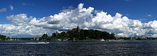
The Thousand Islands constitute a North American archipelago of 1,864 islands that straddles the Canada–US border in the Saint Lawrence River as it emerges from the northeast corner of Lake Ontario. They stretch for about 50 miles (80 km) downstream from Kingston, Ontario. The Canadian islands are in the province of Ontario and the U.S. islands in the state of New York.
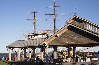
Clayton is a town in Jefferson County, New York, United States. The population was 5,153 at the 2010 census. The town is named after John M. Clayton, a federal political leader from Delaware.

Gateway National Recreation Area is a 26,607-acre (10,767 ha) U.S. National Recreation Area in New York City and Monmouth County, New Jersey. It provides recreational opportunities that are not commonly found in a dense urban environment, including ocean swimming, bird watching, boating, hiking and camping. More than 8.7 million people visited Gateway National Recreation Area in 2022, making it the fourth-most visited unit of the National Park Service.

The Thousand Islands International Bridge is an American-maintained international bridge system over the Saint Lawrence River connecting northern New York in the United States with southeastern Ontario in Canada. Constructed in 1937, with additions in 1959, the bridges span the Canada–US border in the middle of the Thousand Islands region. All bridges in the system carry two lanes of traffic, one in each direction, with pedestrian sidewalks.
Kring Point State Park is a 61-acre (0.25 km2) state park located on the St. Lawrence River in the Town of Alexandria in Jefferson County, New York. The park is north of Alexandria Bay near the St. Lawrence County line and is connected to NY 12 by Kring Point Road.
Mary Island State Park is a 13-acre (5.3 ha) state park located in the St. Lawrence River in Jefferson County, New York. The park is situated in the Town of Alexandria on the east end of Wellesley Island, and is accessible only by boat.

Sam's Point Preserve, or Sam's Point Dwarf Pine Ridge Preserve, is a 4,600-acre (19 km2) preserve in Ulster County on the highest point of the Shawangunk Ridge in New York, on the Wawarsing, New York-Shawangunk town line. It is owned and managed by the New York State Office of Parks, Recreation and Historic Preservation after having previously been managed by The Nature Conservancy. Its unique environment features dwarf pitch pine trees along the ridgetop. Located within the park is Lake Maratanza, the highest lake on the ridge, and the Ellenville Fault Ice Caves.
Fishers Landing is a hamlet and census-designated place (CDP) in the town of Orleans in Jefferson County, New York, United States. It is just southwest of Grass Point State Park in the Thousand Islands region of New York. As of the 2010 census the community had a population of 89.

Sandy Island Beach State Park is a New York State park on the eastern shore of Lake Ontario. Its highlight is a 1,500-foot (460 m) natural sandy beach. The park is near the southern end of a notable 17-mile (27 km) length of sandy shoreline, coastal dunes, and wetlands ; a 1959 study noted that "The eastern end of Lake Ontario contains not only the finest beaches on the entire lake but also the finest wildlife habitat."
The Volgenau Virginia Coast Reserve is a biosphere reserve created by The Nature Conservancy in the early 1970s. It consists of 40,000 acres across 14 of the Virginia Barrier Islands along the Atlantic coast of the Virginia portion of the Delmarva Peninsula, including Parramore Island, Hog Island, Virginia, Smith Island, Virginia, Assawoman Island, and Metompkin Island. These barrier islands play an important role in sheltering the mainland portions of the Eastern Shore of Virginia from the impact of coastal storms and are important for breeding and migrating beach nesting and colonial waterbirds, including piping plovers. It also serves as the research location for the Virginia Coast Reserve Long-Term Ecological Research project.
Deer Lick Nature Sanctuary is a protected forest and gorge in Cattaraugus County, New York. The preserve is within Zoar Valley near Gowanda, and is managed by The Nature Conservancy.
Thompson Pond in Pine Plains, New York is a 75-acre (30 ha) 15,000-year-old glacial kettle pond at the foot of 1,403-foot (428 m) Stissing Mountain. It is the source of Wappinger Creek, a tributary of the Hudson River that drains much of Dutchess County.

Thousand Springs State Park is a public recreation and nature preservation area consisting of multiple units — Billingsley Creek, Earl M. Hardy Box Canyon Springs Nature Preserve, Malad Gorge, Niagara Springs, and Ritter Island — in Gooding County, Idaho.

Thousand Island Park, also known as TI Park, is a hamlet and census-designated place (CDP) in the town of Orleans, Jefferson County, New York, United States, in the Thousand Islands region on the St. Lawrence River. Founded in 1875 as a holiday camp, the incorporated community remains a seasonal summer community; despite 323 housing units, there was only a population of 31 permanent residents as of the 2010 census.

The Georgia Conservancy is a non-profit environmental organization in the U.S. state of Georgia that collaborates, advocates, and educates to protect Georgia's natural environment. It was founded in 1967. Called "the state's most influential environmental organization" by Georgia Trend magazine, the Georgia Conservancy focuses on environmental advocacy, land conservation, coastal protection, stream protection, outdoor recreation, stewardship, and growth management. Its mission is: “To protect Georgia's natural resources for present and future generations by advocating sound environmental policies, advancing sustainable growth practices and facilitating common-ground solutions to environmental challenges.”
Marshlands Conservancy is a 147-acre nature preserve in the city of Rye, New York, that is fully owned and operated by Westchester County Parks. It has numerous wildlife habitats from ponds to creeks to a large meadow area, succession forest, freshwater wetlands and the only extensive salt marsh in Westchester. It borders Long Island Sound and can be entered via an easement on the historic Boston Post Road. It is one of 5 properties that together constitute the Boston Post Road Historic District. It has high archaeological sensitivity. The conservancy has also been designated an Important Bird Area.

