Alexandria Bay, New York

Last updated

Alexandria Bay, New York
Alexbaypan.JPG
Boldt Castle at 20 below F.jpg
Tour Boat passing Longue Vue Island 1.jpg
Boldt yacht house 3.jpg
Left to right from top: panorama of Alexandria Bay, Boldt Castle, Tour Boat passing Longue Vue Island, George C. Boldt Yacht House
Motto: 
"Heart of the Thousand Islands"
USA New York location map.svg
Red pog.svg
Alexandria Bay
Usa edcp location map.svg
Red pog.svg
Alexandria Bay
Coordinates: 44°20′9″N75°54′53″W / 44.33583°N 75.91472°W / 44.33583; -75.91472
Country United States
State New York
RegionThe Thousand Islands (New York)
County Jefferson
Town Alexandria
Area
[1]
  Total1.51 sq mi (3.90 km2)
  Land0.75 sq mi (1.94 km2)
  Water0.76 sq mi (1.96 km2)
Elevation
284 ft (87 m)
Population
 (2020)
  Total924
  Density1,233.64/sq mi (476.12/km2)
Time zone UTC-5 (Eastern (EST))
  Summer (DST) UTC-4 (EDT)
ZIP code
13607
Area code 315
FIPS code 36-01187
GNIS feature ID0942309
Website www.villageofalexandriabay.com

Alexandria Bay is a village in Jefferson County, New York, United States, within the town of Alexandria. It is located in the Thousand Islands region of northern New York. The population of the village was 1,078 at the 2010 United States Census. [2] It lies near the Thousand Islands Border Crossing of Canada and the United States.

Contents

History

Settlement began around 1817. By 1836, the community had about 25 dwellings.

The George C. Boldt Yacht House, Church of Saint Lawrence, Cornwall Brothers' Store, Holland Library, Ingleside, and Longue Vue Island are listed on the National Register of Historic Places. [3]

In its heyday as a late 19th century and early 20th century resort, its main access was via steamer from Clayton, NY. Its nearest rail connection was Redwood on the Rome, Watertown and Ogdensburg Railroad's Rochester line bound for Ogdensburg. [4] [5] [6]

Geography

According to the United States Census Bureau, the village has a total area of 1.53 square miles (3.95 km2), of which 0.76 square miles (1.98 km2) are land and 0.76 square miles (1.97 km2), or 49.77%, are water. [2] The village is located on the south bank of the Saint Lawrence River near the U.S. and Canada international border. Keewaydin State Park is southwest of the village.

New York State Route 12 and New York State Route 26 intersect at the only stoplight in the village. NY-12 leads northeast (downriver) 36 miles (58 km) to Ogdensburg and southwest 11 miles (18 km) to Clayton. NY-26 has its northern terminus at Alexandria Bay and leads southeast 11 miles (18 km) to Theresa. Interstate 81 intersects NY-12 4 miles (6.4 km) southwest of Alexandria Bay, leading south 25 miles (40 km) to Watertown and 94 miles (151 km) to Syracuse, and north to the Thousand Islands Bridge into Canada.

Buildings

The village has a number of properties on the National Register of Historic Places.

Historic Sites

The following are the historic sites in Alexandria Bay of such significance as to be listed on the National Register of Historic Places.

Site NameImageLocationComment
1 Cornwall Brothers' Store Corwall Brothers' Store 2017.jpg 2 Howell PlaceAdded to the National Register of Historic Places, May 2, 1975
2 George C. Boldt Yacht House Boldt Castle's Yacht House.jpg 22320 Boathouse RoadAdded to the National Register of Historic Places, April 26, 1978
3 Ingleside Cherry Island, Alexandria BayAdded to the National Register of Historic Places, April 16, 1980
4 Longue Vue Island Longue Vue Island Postcard.jpg Longue Vue Island, Alexandria BayAdded to the National Register of Historic Places, November 4, 1982
5 Church of Saint Lawrence Church of St Lawrence in Alexandria Bay, New York. East side.jpg 7 Fuller StreetAdded to the National Register of Historic Places, May 16, 1997
6 Holland Library Holland Library - Alexandria Bay NY.jpg 7 Market StreetAdded to the National Register of Historic Places, November 15, 2002

Demographics

Historical population
CensusPop.Note
1860 120
1880 587
1890 1,12391.3%
1900 1,51134.6%
1910 1,89925.7%
1920 1,649−13.2%
1930 1,95218.4%
1940 1,748−10.5%
1950 1,688−3.4%
1960 1,583−6.2%
1970 1,440−9.0%
1980 1,265−12.2%
1990 1,194−5.6%
2000 1,088−8.9%
2010 1,078−0.9%
2020 924−14.3%
U.S. Decennial Census [7]

As of the census [8] of 2000, there were 1,088 people, 482 households, and 270 families residing in the village. The population density was 1,473.9 inhabitants per square mile (569.1/km2). There were 624 housing units at an average density of 845.3 per square mile (326.4/km2). The racial makeup of the village was 99.08% White, 0.37% Hispanic or Latino of any race, 0.09% African American, 0.09% Native American, and 0.74% from two or more races.

There were 482 households, out of which 24.7% had children under the age of 18 living with them, 38.4% were married couples living together, 14.9% had a female householder with no husband present, and 43.8% were non-families. 38.6% of all households were made up of individuals, and 15.8% had someone living alone who was 65 years of age or older. The average household size was 2.12 and the average family size was 2.81.

In the village, the population was spread out, with 20.3% under the age of 18, 5.3% from 18 to 24, 27.7% from 25 to 44, 23.4% from 45 to 64, and 23.3% who were 65 years of age or older. The median age was 43 years. For every 100 females, there were 80.7 males. For every 100 females age 18 and over, there were 79.9 males.

The median income for a household in the village was $29,338, and the median income for a family was $36,979. Males had a median income of $31,250 versus $21,429 for females. The per capita income for the village was $16,875. About 11.0% of families and 13.5% of the population were below the poverty line, including 16.3% of those under age 18 and 18.7% of those age 65 or over.

According to the 2008-2012 American Community Survey, the total population of Alexandria Bay was 1,999 and 95.5% white. 12.6% of the population over 25 does not have a high school or equivalent degree. Median household income, in 2012 inflation adjusted dollars, was $37,303. [9]

Local attractions

Tour boat on the Saint Lawrence River Alexandria bay saint lawrence uncle sam 05.07.2012.jpg
Tour boat on the Saint Lawrence River

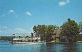
While Alexandria Bay has a relatively low population during the winter months and has no colleges, the late spring, summer, and early fall seasons bring an influx of vacationers and avid boaters that cause the population of the village to exceed 15,000. Several motels and hotels are available in the immediate village area. Boat tours are available of the bay and river area daily.

Boldt Castle is a 120-room mansion on Heart Island, located near Alexandria Bay. The castle was designed by the firm of W. D. Hewitt and G.W. Hewitt, Architects of Philadelphia, who also designed Druim Moir Castle in Philadelphia. Boldt Castle was built at the turn of the century by multi-millionaire George C. Boldt for his wife, Louise, as a testimony of his love for her. Mr. Boldt invested over $2.5 million to build this replica of a Rhineland castle.

Boldt planned on presenting it to his wife on Valentine's Day. Work was underway on the eleven buildings that would comprise the castle complex when in January 1904 Louise Boldt died, ending the dreams of a lifetime. George Boldt ordered that all work be stopped and for 73 years the Castle and the other structures on the island were left to the forces of nature. The Thousand Islands Bridge Authority acquired the property in 1977; since that time, several million dollars have been spent rehabilitating and restoring the castle and surrounding structures. Ferries allow access to the castle on an hourly schedule daily. In 1979, the movie Fear No Evil was filmed at several sites in and around Boldt Castle, marking the only time the castle has made an appearance in cinema.

Every August, 10 days are devoted to "Bill Johnston's Pirate Days", a town-wide festival that features professional performers acting out pirate battles and a "siege" of the town by the "Pirate of the Thousand Islands", Bill Johnston, whom the festival is named after. It is encouraged that attendees dress in pirate attire, as do the actors who line the streets. The festival is also educational, with many groups providing galleries, displays, and informative presentations of the weapons and ships used during the Golden Age of Piracy.

Economy

The total value of exports of Alexandria Bay, New York was $6.73 billion in 2020. [10]

Airport

Maxson Airfield [11] (FAA LID: 89NY) is a privately owned, private-use general aviation airport located two nautical miles (3.7 km; 2.3 mi) south of the central business district of Alexandria Bay. It once had commercial service provided by Mohawk Airlines. At that time, the airport bore the IATA airport code AXB.

The Maxson Airport was originally owned by Howard C. Maxson. He ran it as a grass-field airport until his death in 1984. Howard Maxson would provide airplane tours over the 1000 Islands during the summer as well as flight instruction.

Related Research Articles

<span class="mw-page-title-main">Jefferson County, New York</span> County in New York, United States

Jefferson County is a county on the northern border of the U.S. state of New York. As of the 2020 census, the population was 116,721. Its county seat is Watertown. The county is named after Thomas Jefferson, third President of the United States of America. It is adjacent to Lake Ontario, southeast from the Canada–US border of Ontario.

<span class="mw-page-title-main">Plainfield, Connecticut</span> Town in Connecticut, United States

Plainfield is a town in Windham County, Connecticut, United States. The town is part of the Northeastern Connecticut Planning Region. The population was 14,973 at the 2020 census. The town comprises four villages: Plainfield, Moosup, Wauregan, and Central Village. Each village has their own respective United States Post Office and fire department. The entire town is serviced by the 860 area code.

<span class="mw-page-title-main">Alexandria, New York</span> Town in New York, United States

Alexandria is a town in the Thousand Islands region of the U.S. state of New York, within Jefferson County. The town's population was 4,061 at the 2010 United States Census. The town is named after Alexander LeRay, the son of an early developer. The village of Alexandria Bay is within the town.

Redwood is a hamlet and census-designated place (CDP) in Jefferson County, New York, United States. As of the 2010 census, the population was 605.

<span class="mw-page-title-main">Lisbon, New York</span> Town in New York, United States

Lisbon is a town in St. Lawrence County, New York, United States. The population was 4,102 at the 2010 census.

<span class="mw-page-title-main">Oswegatchie, New York</span> Town in New York, United States

Oswegatchie is a town in St. Lawrence County, New York, United States. The population was 4,397 at the 2010 census. The name reportedly means "Black Water". It is on the northern border of the county and is adjacent to the city of Ogdensburg.

<span class="mw-page-title-main">Huntington Bay, New York</span> Village in New York, United States

Huntington Bay is a village in the Town of Huntington in Suffolk County, on East Neck on the North Shore of Long Island, in New York, United States. The population was 1,425 at the time of the 2010 census. It is considered part of the greater Huntington area, which is anchored by Huntington.

<span class="mw-page-title-main">Saltaire, New York</span> Village in New York, United States

Saltaire is a village on Fire Island in Islip, Suffolk County, New York, United States. The year-round population was 37 at the 2010 census, which, as a summer beach community, increases many times over in the summer.

<span class="mw-page-title-main">Thousand Islands</span> Archipelago in the Saint Lawrence River

The Thousand Islands constitute a North American archipelago of 1,864 islands that straddles the Canada–US border in the Saint Lawrence River as it emerges from the northeast corner of Lake Ontario. They stretch for about 50 miles (80 km) downstream from Kingston, Ontario. The Canadian islands are in the province of Ontario and the U.S. islands in the state of New York.

<span class="mw-page-title-main">Plattsburgh (town), New York</span> Town in New York, United States

Plattsburgh is a town in Clinton County, New York, United States. The population was 11,886 at the 2020 census. The town is named after Zephaniah Platt, an early land owner, and it surrounds the separate and more populous city of the same name. The town is in the eastern part of the county, in the North Country region of the state of New York. The region's airport, Plattsburgh International Airport, is located in the southern part of the town.

Brownville is a town in Jefferson County, New York, United States. The population was 6,263 at the 2010 census, up from 5,839 in 2000. The town is named after Jacob Brown, an early settler and leader.

Cape Vincent is a village in Jefferson County, New York, United States. The population was 726 at the 2010 census. The village is in the west-central part of the town of Cape Vincent and is northwest of Watertown.

Cape Vincent is a town in Jefferson County, New York, United States. The population was 2,765 at the 2020 census.

Clayton is a village in the town of Clayton in Jefferson County, New York, United States. The village population was 1,705 at the 2020 census.

<span class="mw-page-title-main">Clayton, New York</span> Town in New York, United States

Clayton is a town in Jefferson County, New York, United States. The population was 5,153 at the 2010 census. The town is named after John M. Clayton, a federal political leader from Delaware.

Philadelphia is a village in Jefferson County, New York, United States. The population was 1,252 at the 2010 census, down from 1,519 in 2000.

Theresa is a village in the town of Theresa in Jefferson County, New York, United States. The population was 863 at the 2010 census. The village is northeast of Watertown.

Hammond is a town in St. Lawrence County, New York, United States. The population was 1,191 at the 2010 census. The name is derived from early land owner Abijah Hammond.

<span class="mw-page-title-main">Babylon, New York</span> Town in New York, United States

The Town of Babylon is one of ten towns in Suffolk County, New York, United States. Its population was 218,223 as of the 2020 census. Parts of Jones Beach Island, Captree Island and Fire Island are in the southernmost part of the town. It borders Nassau County to the west and the Atlantic Ocean to the south. At its westernmost point, it is about 20 miles (32 km) from New York City at the Queens border, and about 30 miles (48 km) from Manhattan. The village of Babylon is also within the town.

Philadelphia is a town in Jefferson County, New York, United States. The population was 1,947 at the 2010 census, down from 2,140 in 2000.

References

  1. "ArcGIS REST Services Directory". United States Census Bureau. Retrieved September 20, 2022.
  2. 1 2 "Geographic Identifiers: 2010 Census Summary File 1 (G001): Alexandria Bay village, New York". American Factfinder. U.S. Census Bureau. Archived from the original on February 13, 2020. Retrieved September 4, 2018.
  3. "National Register Information System". National Register of Historic Places . National Park Service. July 9, 2010.
  4. 'Official Guide of the Railways.' January 1910, New York Central section, RW&O division
  5. New York Central timetable, August 1912, Tables 2, 4
  6. New York Central timetable, June 17, 1951, Tables 45, 59 https://streamlinermemories.info/NYC/NYC51-6TT.pdf
  7. "Census of Population and Housing". Census.gov. Retrieved June 4, 2015.
  8. "U.S. Census website". United States Census Bureau . Retrieved January 31, 2008.
  9. "Social Explorer Tables: ACS 2008 to 2012 (5-Year Estimates)(SE), ACS 2008 -- 2012 (5-Year Estimates), Social Explorer; U.S. Census Bureau".{{cite journal}}: Cite journal requires |journal= (help)
  10. "Alexandria Bay, NY | OEC - The Observatory of Economic Complexity".
  11. "Maxson Airfield - Alexandria Bay - Thousand Islands Destination Airport". Maxson Airfield. Archived from the original on November 8, 2016. Retrieved November 11, 2016.