
Adams Center is a hamlet and census-designated place (CDP) in the town of Adams in Jefferson County, New York, United States. The population was 1,492 during the 2020 decennial census.
Calcium is a census-designated place (CDP) in Jefferson County, New York, United States. The population was 3,573 as of the 2020 census. The CDP is in the town of Le Ray and includes the hamlets of Calcium and Sanfords Four Corners.
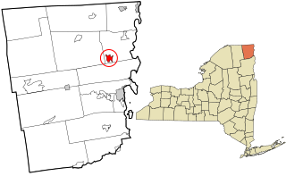
La Fargeville is a hamlet and census-designated place (CDP) in the town of Orleans in Jefferson County, New York, United States. The population was 733 at the 2020 census. The hamlet is named after John Frederick La Farge, one of the early proprietors of the town. La Fargeville was once a village, but dissolved its municipal corporation in 1922.
Redwood is a hamlet and census-designated place (CDP) in Jefferson County, New York, United States. As of the 2010 census, the population was 605.
Fishers Landing is a hamlet and census-designated place (CDP) in the town of Orleans in Jefferson County, New York, United States. It is just southwest of Grass Point State Park in the Thousand Islands region of New York. As of the 2020 census the community had a population of 119.
Oxbow is a hamlet and census-designated place (CDP) in the town of Antwerp, Jefferson County, New York, United States. As of the 2010 census it had a population of 108.
Brasher Falls is the largest hamlet and a census-designated place (CDP) in the town of Brasher in St. Lawrence County, New York, United States. As of the 2010 census, it had a population of 669.
Schroon Lake is a hamlet and census-designated place (CDP) in the town of Schroon in Essex County, New York, United States. The population was 833 at the 2010 census, or just over half of the total population of the town of Schroon.
Three Mile Bay is a hamlet and census-designated place (CDP) in the town of Lyme in Jefferson County, New York, United States. The elevation is 259 feet (79 m). As of the 2010 census it had a population of 227.

Jefferson Valley-Yorktown, commonly known as Jefferson Valley, is a census-designated place (CDP) located in the town of Yorktown in Westchester County, New York, United States. The population was 14,142 at the 2010 census. It is a hot spot for local shoppers, due to its Jefferson Valley Mall.

Freedom Plains is a hamlet and census-designated place (CDP) in Dutchess County, New York, United States. As of the 2010 census the population was 421.

Hyde Park is a hamlet and census-designated place (CDP) in the town of Hyde Park, Dutchess County, New York, United States. Its population was 1,908 as of the 2010 census.
Belleville is a hamlet and census-designated place (CDP) in the town of Ellisburg, Jefferson County, New York, United States. The population was 226 at the 2010 census.
West Chazy is a hamlet and census-designated place in the town of Chazy in Clinton County, New York, United States. The population was 529 at the 2010 census.
Willsboro is a hamlet and census-designated place (CDP) in the town of Willsboro in Essex County, New York, United States. The population of the CDP was 753 at the 2010 census, out of a total town population of 2,025.
Wilmington is a hamlet and census-designated place (CDP) in the town of Wilmington in Essex County, New York, United States. The population of the CDP was 843 at the 2020 census, out of a total town population of 880.
Fort Covington is a census-designated place (CDP) within the town of Fort Covington, Franklin County, New York, United States. It consists of the hamlet of Fort Covington, as well as a large amount of rural land surrounding the hamlet, such that the CDP occupies about one half of the area within the town limits. The population of the CDP was 1,308 at the 2010 census, out of a total town population of 1,676.
Henderson is a hamlet and census-designated place (CDP) in the town of Henderson, Jefferson County, New York, United States. The population of the CDP was 224 at the 2010 census, out of 1,360 in the entire town of Henderson.
Rodman is a hamlet and census-designated place (CDP) in the town of Rodman, Jefferson County, New York, United States. As of the 2010 census, the CDP population was 153, out of 1,176 in the entire town of Rodman.
Pamelia Center is a hamlet and census-designated place (CDP) in Jefferson County, New York, United States. Its population was 264 as of the 2010 census. The community is located at the junction of New York State Route 37 and New York State Route 342.


