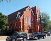
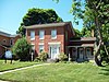
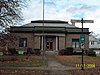
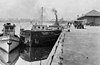
[3] Name on the Register Image Date listed [4] Location City or town Description 1 Ascension Roman Catholic Church Complex Ascension Roman Catholic Church Complex August 29, 2016 (# 16000592 168 and 172 Robinson St. and 61, 69, and 91 Keil St. 43°01′59″N 78°52′39″W / 43.032969°N 78.8775367°W / 43.032969; -78.8775367 (Ascension Roman Catholic Church Complex ) North Tonawanda Complex built around 1894 church was social center of immigrant life in early 20th-century North Tonawanda 2 Bacon-Merchant-Moss House Bacon-Merchant-Moss House May 30, 2007 (# 07000481 32 Cottage St. 43°10′05″N 78°41′40″W / 43.168056°N 78.694444°W / 43.168056; -78.694444 (Bacon-Merchant-Moss House ) Lockport Federal style stone dwelling built in 1832; part of the Multiple Property Submission for the Stone Buildings of Lockport, New York. 3 Bewley Building Bewley Building December 3, 2018 (# 100003153 4 Market Street 43°10′15″N 78°41′25″W / 43.17079°N 78.69036°W / 43.17079; -78.69036 (Bewley Building ) Lockport Irregularly shaped two-story brick Italian Renaissance Revival commercial block that has been a major part of city's downtown since 1928 4 Constant Riley W. Bixby House Constant Riley W. Bixby House November 15, 2002 (# 02001333 2888 Carmen Rd. 43°15′42″N 78°29′20″W / 43.261667°N 78.488889°W / 43.261667; -78.488889 (Constant Riley W. Bixby House ) Hartland Two-story cobblestone dwelling built in 1845; part of the Multiple Property Submission for the Cobblestone Architecture of New York State. 5 Col. William M. and Nancy Ralston Bond House Col. William M. and Nancy Ralston Bond House April 20, 1995 (# 95000529 143 Ontario St. 43°10′16″N 78°41′56″W / 43.171111°N 78.698889°W / 43.171111; -78.698889 (Col. William M. and Nancy Ralston Bond House ) Lockport Brick dwelling constructed in 1823 in the late Federal / early Greek Revival style. 6 Amzi Bradley Farmstead Amzi Bradley Farmstead November 15, 2002 (# 02001332 8915 Bradley Rd. 43°16′14″N 78°31′24″W / 43.270556°N 78.523333°W / 43.270556; -78.523333 (Amzi Bradley Farmstead ) Hartland Two-story cobblestone dwelling built in 1836; part of the Multiple Property Submission for the Cobblestone Architecture of New York State. 7 Carnegie Library Carnegie Library July 14, 1995 (# 95000851 249 Goundry St. 43°01′35″N 78°52′09″W / 43.026389°N 78.869167°W / 43.026389; -78.869167 (Carnegie Library ) North Tonawanda Philanthropist Andrew Carnegie funded library constructed in 1903; now local arts center. 8 John Carter Farmstead John Carter Farmstead May 30, 2007 (# 07000490 206 Lake Rd. 43°15′51″N 79°02′46″W / 43.264167°N 79.046111°W / 43.264167; -79.046111 (John Carter Farmstead ) Youngstown Italianate style brick dwelling and barn. 9 Chase-Crowley-Keep House Chase-Crowley-Keep House May 21, 2008 (# 08000451 305 High St. 43°09′52″N 78°41′08″W / 43.164444°N 78.685556°W / 43.164444; -78.685556 (Chase-Crowley-Keep House ) Lockport Stone dwelling built in 1856; part of the Multiple Property Submission for the Stone Buildings of Lockport, New York. 10 Chase-Hubbard-Williams House Chase-Hubbard-Williams House May 21, 2008 (# 08000452 327 High St. 43°09′50″N 78°41′06″W / 43.163889°N 78.685°W / 43.163889; -78.685 (Chase-Hubbard-Williams House ) Lockport Stone dwelling built in 1870; part of the Multiple Property Submission for the Stone Buildings of Lockport, New York. 11 Cold Springs Cemetery Cold Springs Cemetery September 10, 2004 (# 04000989 4849 Cold Springs Rd. 43°10′59″N 78°39′25″W / 43.183056°N 78.656944°W / 43.183056; -78.656944 (Cold Springs Cemetery ) Lockport Cemetery founded in 1815; notable interments include Erie Canal proponent Jesse Hawley and Cuthbert W. Pound . 12 Nathan Comstock Jr. House Nathan Comstock Jr. House September 29, 2011 (# 11000707 299 Old Niagara Road 43°11′14″N 78°40′47″W / 43.187222°N 78.679722°W / 43.187222; -78.679722 (Nathan Comstock Jr. House ) Lockport Stone Buildings of Lockport, New York MPS 13 Conkey House Conkey House May 30, 2003 (# 03000479 202 Akron St. 43°09′43″N 78°40′09″W / 43.161944°N 78.669167°W / 43.161944; -78.669167 (Conkey House ) Lockport Federal style stone dwelling built in 1842; part of the Multiple Property Submission for the Stone Buildings of Lockport, New York. 14 DAY PECKINPAUGH , (canal motorship) DAY PECKINPAUGH , (canal motorship) December 28, 2005 (# 05001486 NYS Barge Canal 43°09′54″N 78°42′13″W / 43.165°N 78.703611°W / 43.165; -78.703611 (DAY PECKINPAUGH , (canal motorship) Lockport Canal motorship built in 1921. 15 Dick Block Dick Block November 21, 2012 (# 12000957 62 Webster St 43°01′25″N 78°52′41″W / 43.023647°N 78.877975°W / 43.023647; -78.877975 (Dick Block ) North Tonawanda 16 District #10 Schoolhouse District #10 Schoolhouse December 1, 2000 (# 00001467 9713 Seaman Rd. 43°16′53″N 78°29′20″W / 43.281389°N 78.488889°W / 43.281389; -78.488889 (District #10 Schoolhouse ) Hartland Cobblestone one-room school built in 1845; part of the Multiple Property Submission for the Cobblestone Architecture of New York State. 17 Dole House Dole House May 30, 2003 (# 03000485 74 Niagara St. 43°10′11″N 78°41′52″W / 43.1697°N 78.6978°W / 43.1697; -78.6978 (Dole House ) Lockport Federal style stone dwelling built in 1840; part of the Multiple Property Submission for the Stone Buildings of Lockport, New York. 18 First Baptist Church First Baptist Church September 15, 2004 (# 04000987 6073 East Ave. 43°17′11″N 78°42′29″W / 43.2864°N 78.7081°W / 43.2864; -78.7081 (First Baptist Church ) Newfane Cobblestone church built in 1843; part of the Multiple Property Submission for the Cobblestone Architecture of New York State. 19 Forsyth-Warren Farm Forsyth-Warren Farm January 24, 2020 (# 100004910 5182 Ridge Rd. 43°12′57″N 78°45′18″W / 43.2157°N 78.7549°W / 43.2157; -78.7549 (Forsyth-Warren Farm ) Cambria 20 Fort Niagara Light Fort Niagara Light July 19, 1984 (# 84002809 Niagara River 43°15′42″N 79°03′39″W / 43.2617°N 79.0608°W / 43.2617; -79.0608 (Fort Niagara Light ) Youngstown Lighthouse built in 1872; deactivated in 1993. 21 Frontier House Frontier House July 8, 1974 (# 74001278 460 Center St. 43°10′23″N 79°02′35″W / 43.1731°N 79.0431°W / 43.1731; -79.0431 (Frontier House ) Lewiston Stone former hotel structure built in 1824. 22 Gibbs House Gibbs House May 30, 2003 (# 03000482 98 N. Transit St. 43°10′17″N 78°41′54″W / 43.1714°N 78.6983°W / 43.1714; -78.6983 (Gibbs House ) Lockport Two-story stone dwelling built in 1850; part of the Multiple Property Submission for the Stone Buildings of Lockport, New York. 23 Harrington Cobblestone Farmhouse and Barn Complex Harrington Cobblestone Farmhouse and Barn Complex December 7, 2005 (# 05001396 8993 Ridge Rd. 43°14′37″N 78°31′35″W / 43.2436°N 78.5264°W / 43.2436; -78.5264 (Harrington Cobblestone Farmhouse and Barn Complex ) Hartland Cobblestone house built in 1843; part of the Multiple Property Submission for the Cobblestone Architecture of New York State. 24 Harrison Radiator Corporation Factory Upload image April 22, 2021 (# 100006486 190 Walnut St. and 160 Washburn St. 43°10′12″N 78°41′11″W / 43.1700°N 78.6864°W / 43.1700; -78.6864 (Harrison Radiator Corporation Factory ) Lockport 25 Allan Herschell Carousel Factory Allan Herschell Carousel Factory April 18, 1985 (# 85000856 180 Thompson St. 43°01′46″N 78°52′24″W / 43.0294°N 78.8733°W / 43.0294; -78.8733 (Allan Herschell Carousel Factory ) North Tonawanda Carousel factory built 1910-1915; now museum. 26 The Herschell–Spillman Motor Company Complex The Herschell–Spillman Motor Company Complex June 5, 2013 (# 13000358 184 Sweeney St. 43°01′24″N 78°52′26″W / 43.0232°N 78.87384°W / 43.0232; -78.87384 (The Herschell–Spillman Motor Company Complex ) North Tonawanda 27 High and Locust Streets Historic District High and Locust Streets Historic District November 19, 2014 (# 14000937 23-54 Park Pl., 143-399 High, 119-224 Locust & 23-43 Spalding Sts. 43°09′51″N 78°41′16″W / 43.1643°N 78.6878°W / 43.1643; -78.6878 (High and Locust Streets Historic District ) Lockport Well-preserved neighborhood of homes built by affluent residents in late 19th century 28 Hopkins House Hopkins House May 30, 2003 (# 03000480 83 Monroe St. 43°10′39″N 78°41′39″W / 43.1775°N 78.6942°W / 43.1775; -78.6942 (Hopkins House ) Lockport Stone dwelling built in 1833; part of the Multiple Property Submission for the Stone Buildings of Lockport, New York. 29 House at 8 Berkley Drive House at 8 Berkley Drive May 4, 2009 (# 09000287 8 Berkley Drive 43°09′19″N 78°41′17″W / 43.1553°N 78.6881°W / 43.1553; -78.6881 (House at 8 Berkley Drive ) Lockport Prairie style home constructed in 1957. 30 Lewiston Mound Lewiston Mound January 21, 1974 (# 74001279 Earl W. Brydges Artpark State Park 43°10′00″N 79°02′40″W / 43.1666°N 79.0445°W / 43.1666; -79.0445 (Lewiston Mound ) Lewiston Indian burial mound . 31 Lockport Industrial District Lockport Industrial District November 11, 1975 (# 75001211 Bounded roughly by Erie Canal, Gooding, Clinton, and Water Sts. 43°10′24″N 78°41′31″W / 43.173333°N 78.691944°W / 43.173333; -78.691944 (Lockport Industrial District ) Lockport Includes two sets of Erie Canal locks constructed in 1859 and in 1909-1918 and related industrial structures or remains. 32 Lower Landing Archeological District Lower Landing Archeological District July 18, 1974 (# 74001280 Address Restricted Lewiston Western end of portage around Niagara Falls. 33 Lower Niagara River Spear Fishing Docks Historic District Upload image August 29, 2012 (# 12000578 Address Restricted Lewiston 34 Lowertown Historic District Lowertown Historic District June 4, 1973 (# 73001225 Roughly bounded by Erie Canal and New York Central RR 43°10′47″N 78°40′42″W / 43.179722°N 78.678333°W / 43.179722; -78.678333 (Lowertown Historic District ) Lockport Residential district with structures constructed 1820s to 1860s. 35 Maloney House Maloney House May 30, 2003 (# 03000481 279 Caledonia St. 43°10′21″N 78°42′14″W / 43.1725°N 78.703889°W / 43.1725; -78.703889 (Maloney House ) Lockport Stone dwelling built about 1860; part of the Multiple Property Submission for the Stone Buildings of Lockport, New York. 36 Benjamin C. Moore Mill Benjamin C. Moore Mill June 19, 1973 (# 73001226 Pine St. on the Erie Canal 43°10′14″N 78°41′34″W / 43.170556°N 78.692778°W / 43.170556; -78.692778 (Benjamin C. Moore Mill ) Lockport Stone former grist mill built in 1864; served as city hall and now welcome center. 37 Morse Cobblestone Farmhouse Morse Cobblestone Farmhouse August 30, 2010 (# 10000591 2773 Maple Road 43°16′51″N 78°48′00″W / 43.280833°N 78.8°W / 43.280833; -78.8 (Morse Cobblestone Farmhouse ) Wilson part of the Cobblestone Architecture of New York State MPS 38 Philo Newton Cobblestone House Philo Newton Cobblestone House November 15, 2002 (# 02001334 3573 Wruck Rd. 43°14′07″N 78°32′04″W / 43.235278°N 78.534444°W / 43.235278; -78.534444 (Philo Newton Cobblestone House ) Hartland Cobblestone house built in 1830; part of the Multiple Property Submission for the Cobblestone Architecture of New York State. 39 New York State Barge Canal New York State Barge Canal October 15, 2014 (# 14000860 Linear across county 43°10′14″N 78°41′36″W / 43.170691°N 78.693315°W / 43.170691; -78.693315 (New York State Barge Canal ) Lockport, Middleport, North Tonawanda, Pendleton, Royalton, Wheatfield Successor to Erie Canal approved by state voters in early 20th century to compete with railroads. 40 Niagara County Courthouse and County Clerk's Office Niagara County Courthouse and County Clerk's Office May 9, 1997 (# 97000417 175 Hawley St. and 139 Niagara St. 43°10′10″N 78°42′03″W / 43.169444°N 78.700833°W / 43.169444; -78.700833 (Niagara County Courthouse and County Clerk's Office ) Lockport Former County Clerk's Office constructed 1856; courthouse built 1886 with later additions. 41 Niagara Power Project Historic District Niagara Power Project Historic District July 3, 2017 (# 100001265 5777 Lewiston Rd. 43°08′26″N 79°02′20″W / 43.14048°N 79.03902°W / 43.14048; -79.03902 (Niagara Power Project Historic District ) Lewiston U.S. half of massive mid-20th century international hydroelectric project tapping the Niagara River 42 North Ridge United Methodist Church North Ridge United Methodist Church December 31, 2002 (# 02001649 3930 North Ridge Rd. 43°12′44″N 78°49′40″W / 43.212222°N 78.827778°W / 43.212222; -78.827778 (North Ridge United Methodist Church ) North Ridge Cobblestone church built in 1848; part of the Multiple Property Submission for the Cobblestone Architecture of New York State. 43 Old Fort Niagara-Colonial Niagara Historic District Old Fort Niagara-Colonial Niagara Historic District October 15, 1966 (# 66000556 N of Youngstown on NY 18 43°15′48″N 79°03′48″W / 43.263333°N 79.063333°W / 43.263333; -79.063333 (Old Fort Niagara-Colonial Niagara Historic District ) Youngstown Fort located at Niagara River and Lake Ontario dating to 1678. 44 Thomas Oliver House Thomas Oliver House November 19, 1998 (# 98001390 175 Locust St. 43°09′56″N 78°40′32″W / 43.165556°N 78.675556°W / 43.165556; -78.675556 (Thomas Oliver House ) Lockport Queen Anne style brick house constructed in 1891. 45 Payne Avenue High School Payne Avenue High School March 7, 2019 (# 100003431 621 Payne Ave. 43°02′24″N 78°52′25″W / 43.0401°N 78.8736°W / 43.0401; -78.8736 (Payne Avenue High School ) North Tonawanda 46 Pound–Hitchins House Pound–Hitchins House January 27, 2015 (# 14001215 325 Summit St. 43°09′11″N 78°42′25″W / 43.153127°N 78.706979°W / 43.153127; -78.706979 (Pound–Hitchins House ) Lockport 1833 Greek Revival stone house built by early settler of Lockport 47 Riviera Theatre Riviera Theatre March 20, 1980 (# 80002731 67 Webster St. 43°01′26″N 78°52′38″W / 43.023889°N 78.877222°W / 43.023889; -78.877222 (Riviera Theatre ) North Tonawanda Theater constructed in 1926; features Mighty Wurlitzer 48 St. John's Episcopal Church St. John's Episcopal Church May 10, 1990 (# 90000687 117 Main St. 43°15′13″N 79°03′01″W / 43.253611°N 79.050278°W / 43.253611; -79.050278 (St. John's Episcopal Church ) Youngstown Gothic Revival style church constructed in 1878 49 Stickney House Stickney House May 30, 2003 (# 03000483 133 Lock St. 43°10′20″N 78°41′33″W / 43.1722°N 78.6925°W / 43.1722; -78.6925 (Stickney House ) Lockport Stone dwelling built in 1854; part of the Multiple Property Submission for the Stone Buildings of Lockport, New York. 50 Sweeney Estate Historic District Upload image August 27, 2020 (# 100005471 Portions of Bryant, Christina, Falconer, Goundry, Grant, Niagara, Oliver, Tremont, and Vandervoot Sts., Lincoln, Payne, Thompson and Whiting Aves., Louisa Pkwy., and Pine Woods Dr. 43°01′55″N 78°52′08″W / 43.0320°N 78.8689°W / 43.0320; -78.8689 (Sweeney Estate Historic District ) North Tonawanda 51 William Taylor House William Taylor House December 4, 2012 (# 12000998 97 S. Main St. 43°12′22″N 78°28′36″W / 43.2061°N 78.4766°W / 43.2061; -78.4766 (William Taylor House ) Middleport 52 Thirty Mile Point Light Thirty Mile Point Light July 19, 1984 (# 84003922 Lake Ontario 30 miles (48 km) east of Niagara River 43°22′29″N 78°29′11″W / 43.3747°N 78.4864°W / 43.3747; -78.4864 (Thirty Mile Point Light ) Somerset Lighthouse constructed in 1875. 53 Town of Niagara District School No. 2 Town of Niagara District School No. 2 February 9, 2005 (# 05000021 9670 Lockport Rd. 43°07′18″N 78°57′03″W / 43.1217°N 78.9508°W / 43.1217; -78.9508 (Town of Niagara District School No. 2 ) Town of Niagara One-room school built in 1878. 54 Union Station Union Station December 2, 1977 (# 77000966 95 Union Ave. 43°10′26″N 78°41′08″W / 43.1739°N 78.6856°W / 43.1739; -78.6856 (Union Station ) Lockport Romanesque style train station constructed in 1889; destroyed by fire and shell remains. 55 US Post Office-Lockport US Post Office-Lockport May 11, 1989 (# 88002345 1 East Ave. 43°10′16″N 78°41′18″W / 43.1711°N 78.6883°W / 43.1711; -78.6883 (US Post Office-Lockport ) Lockport Post office built in 1902-1904; part of the Multiple Property Submission for the US Post Offices in New York State, 1858-1943. 56 US Post Office-Middleport US Post Office-Middleport May 11, 1989 (# 88002353 42 Main St. 43°12′40″N 78°28′37″W / 43.2111°N 78.4769°W / 43.2111; -78.4769 (US Post Office-Middleport ) Middleport One of three post offices in state (along with Frankfort and Lake George ) to use the same modernist-Colonial Revival design. 57 US Post Office-North Tonawanda US Post Office-North Tonawanda May 11, 1989 (# 88002357 141 Goundry St. 43°01′29″N 78°52′23″W / 43.0247°N 78.8731°W / 43.0247; -78.8731 (US Post Office-North Tonawanda ) North Tonawanda Post office built in 1912-1914; part of the Multiple Property Submission for the US Post Offices in New York State, 1858-1943. 58 Van Horn Mansion Van Horn Mansion September 9, 1991 (# 91001149 2165 Lockport-Olcott Rd. 43°18′49″N 78°42′51″W / 43.3136°N 78.7142°W / 43.3136; -78.7142 (Van Horn Mansion ) Newfane Two-story brick mansion built in 1823. 59 Peter D. Walter House Peter D. Walter House May 30, 2007 (# 07000489 127 Ontario St. 43°10′16″N 78°41′54″W / 43.1711°N 78.6983°W / 43.1711; -78.6983 (Peter D. Walter House ) Lockport Two-story stone dwelling built in 1858; part of the Multiple Property Submission for the Stone Buildings of Lockport, New York. 60 Watson House Watson House May 30, 2003 (# 03000486 129 Outwater Dr. 43°10′48″N 78°42′08″W / 43.18°N 78.7022°W / 43.18; -78.7022 (Watson House ) Lockport Two-story stone dwelling built in 1854; part of the Multiple Property Submission for the Stone Buildings of Lockport, New York. 61 White-Pound House White-Pound House May 30, 2003 (# 03000484 140 Pine St. 43°09′58″N 78°41′31″W / 43.1661°N 78.6919°W / 43.1661; -78.6919 (White-Pound House ) Lockport Two-story stone dwelling built in 1835; part of the Multiple Property Submission for the Stone Buildings of Lockport, New York.