Lockport (town), New York

Last updated

Lockport, New York
Niagara County New York incorporated and unincorporated areas Lockport (town) highlighted.svg
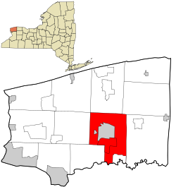
Location in Niagara County and the state of New York
Coordinates: 43°9′2″N78°40′37″W / 43.15056°N 78.67694°W / 43.15056; -78.67694
Country United States
State New York
County Niagara
Government
  Type Town Council
   Town Supervisor Mark C. Crocker (R)
   Town Council
Members' List
Area
[1]
  Total44.90 sq mi (116.28 km2)
  Land44.84 sq mi (116.14 km2)
  Water0.05 sq mi (0.13 km2)
Elevation
630 ft (192 m)
Population
 (2010)
  Total20,529
  Estimate 
(2016) [2]
20,094
  Density448.10/sq mi (173.01/km2)
Time zone UTC-5 (Eastern (EST))
  Summer (DST) UTC-4 (EDT)
ZIP codes
14094-14095
Area code 716
FIPS code 36-43093
GNIS feature ID0979165
Location within Niagara County Niagara-Lockport (town).png
Location within Niagara County

Lockport is a town in Niagara County, New York, United States. The population was 20,529 at the 2010 census. The name is derived from the series of canal locks on the Erie Canal. The locks lift boats from the lowland of Lake Ontario past the Niagara Escarpment.

Contents

The Town of Lockport is in the south-central part of the county and surrounds the City of Lockport.

History

Many early settlers were Quakers and helped make the area a bastion of anti-slavery. The Town of Lockport was established in 1824 from Cambria and Royalton, the same year the canal was completed up to the City of Lockport.

Cold Springs Cemetery was listed on the National Register of Historic Places in 2004. [3]

Geography

According to the United States Census Bureau, the town has a total area of 44.7 square miles (115.8 km2), of which 44.6 square miles (115.6 km2) is land and 0.1 square mile (0.2 km2) (0.18%) is water.

The south border of the town is formed by Tonawanda Creek. The Erie Canal passes through the north part of the town and the City of Lockport. New York State Route 78 marks the west town line of Lockport.

Adjacent cities and towns

Major highways in the Town of Lockport

Demographics

Historical population
CensusPop.Note
1830 3,823
1840 9,125138.7%
1850 12,32335.0%
1860 13,5239.7%
1870 3,032−77.6%
1880 2,847−6.1%
1890 2,773−2.6%
1900 2,585−6.8%
1910 2,399−7.2%
1920 1,833−23.6%
1930 2,72048.4%
1940 3,16016.2%
1950 3,94524.8%
1960 6,49264.6%
1970 8,17726.0%
1980 12,94258.3%
1990 16,59628.2%
2000 19,65518.4%
2010 20,5294.4%
2020 20,5630.2%
U.S. Decennial Census [4]

As of the census [5] of 2010, there were 20,529 people, 8,293 households, and 5,482 families residing in the town. There were 8,680 housing units. The racial makeup of the town was 91.1% White, 4.8% Black or African American, 0.4% Native American, 1.0% Asian, 0.01% Pacific Islander, 0.6% from other races, and 2.1% from two or more races. Hispanic or Latino people of any race were 2.6% of the population.

(2000 Census)[ clarification needed ] There were 7,537 households, out of which 33.3% had children under the age of 18 living with them, 55.4% were married couples living together, 10.7% had a female householder with no husband present, and 30.3% were non-families. 25.3% of all households were made up of individuals, and 8.3% had someone living alone who was 65 years of age or older. The average household size was 2.52 and the average family size was 3.03.

In the town, the population was spread out, with 25.3% under the age of 18, 8.3% from 18 to 24, 30.4% from 25 to 44, 24.2% from 45 to 64, and 11.9% who were 65 years of age or older. The median age was 37 years. For every 100 females, there were 96.6 males. For every 100 females age 18 and over, there were 94.6 males.

The median income for a household in the town was $45,977, and the median income for a family was $55,414. Males had a median income of $41,166 versus $25,810 for females. The per capita income for the town was $22,194. About 6.5% of families and 7.7% of the population were below the poverty line, including 10.8% of those under age 18 and 2.8% of those age 65 or over.

Notable natives

See City of Lockport

Communities and locations in the Town of Lockport

Related Research Articles

<span class="mw-page-title-main">Niagara County, New York</span> County in New York, United States

Niagara County is in the U.S. state of New York. As of the 2020 census, the population was 212,666. The county seat is Lockport. The county name is from the Iroquois word Onguiaahra; meaning the strait or thunder of waters.

<span class="mw-page-title-main">Cambria, New York</span> Town in New York, United States

Cambria is a town in Niagara County, New York, United States. The population was 5,743 at the 2020 census. Cambria is an early name for Wales.

<span class="mw-page-title-main">Hartland, New York</span> Town in New York, United States

Hartland is a town in Niagara County, New York, United States. The population was 4,117 at the 2010 census. The town is named after Hartland, Vermont, the homeplace of some early settlers.

<span class="mw-page-title-main">Niagara, New York</span> Town in New York, United States

Niagara is a town in Niagara County, New York, United States. At the time of the 2010 census, the town had a total population of 8,378. The town is named after the famous waterfall Niagara Falls.

<span class="mw-page-title-main">Olcott, New York</span> CDP in New York, United States

Olcott is a hamlet located in the Town of Newfane in Niagara County, New York, United States. As of the 2010 census, this community population was 1,241. Most locals refer to it as Olcott Beach. It is part of the Buffalo–Niagara Falls Metropolitan Statistical Area.

<span class="mw-page-title-main">Pendleton, New York</span> Town in New York, United States

Pendleton is a town on the southern edge of Niagara County, New York, United States. It is east of the city of Niagara Falls and southwest of the city of Lockport. The population was 6,397 at the 2010 census.

<span class="mw-page-title-main">Porter, New York</span> Town in New York, United States

Porter is a town in Niagara County, New York, United States. The population was 6,771 at the 2010 census. The town was named after Judge Augustus Porter.

<span class="mw-page-title-main">Ransomville, New York</span> CDP in New York, United States

Ransomville is a hamlet located in the Town of Porter in Niagara County, New York, United States. The population was 1,419 at the 2010 census. Portions of the hamlet are also in Town of Wilson and Town of Cambria. Ransomville is north of the City of Niagara Falls and is part of the Buffalo–Niagara Falls Metropolitan Statistical Area.

<span class="mw-page-title-main">Royalton, New York</span> Town in New York, United States

Royalton is a town in Niagara County, New York, United States. The population was 7,660 at the 2010 census.

<span class="mw-page-title-main">Somerset, New York</span> Town in New York, United States

Somerset is a town in Niagara County, New York, United States. The population was 2,662 at the 2010 census. The town is believed to be named after Somerset, New Jersey, the source of some early settlers.

<span class="mw-page-title-main">Wheatfield, New York</span> Town in New York, United States

Wheatfield is a town in Niagara County, New York, United States. The population was 18,117 at the 2010 census. The name stems from the agricultural use of the town lands, the growing of wheat.

<span class="mw-page-title-main">West Seneca, New York</span> Town in New York, United States

West Seneca is a town in Erie County, New York, United States. The population was 44,711 at the 2010 census. West Seneca is a centrally located interior town of the county, and a suburb of Buffalo. West Seneca, Orchard Park and Hamburg form the inner "Southtowns", a cluster of middle-class suburban towns.

<span class="mw-page-title-main">Lewiston, New York</span> Town in New York, United States

Lewiston is a town in Niagara County, New York, United States. The population was 15,944 at the 2020 census. The town and its contained village are named after Morgan Lewis, a governor of New York.

<span class="mw-page-title-main">Wilson, New York</span> Town in New York, United States

Wilson is a town in Niagara County, New York, United States. The population was 5,993 at the 2010 census. The town was named after an early settler, Reuben Wilson, who built and dwelt in a log cabin on the shore of Lake Ontario at the site of what would become the Village of Wilson.

<span class="mw-page-title-main">Newfane, New York</span> Town in New York, United States

Newfane is a town in Niagara County, New York, United States. The population was 9,666 at the 2010 census. The name was suggested by an early settler.

<span class="mw-page-title-main">New York State Route 104</span> Highway in New York

New York State Route 104 (NY 104) is a 182.41-mile-long (293.56 km) east–west state highway in Upstate New York in the United States. It spans six counties and enters the vicinity of four cities—Niagara Falls, Lockport, Rochester, and Oswego—as it follows a routing largely parallel to the southern shoreline of Lake Ontario, along a ridge of the old shoreline of Glacial Lake Iroquois. The western terminus of NY 104 is an intersection with NY 384 in Niagara Falls, Niagara County, while its eastern terminus is a junction with NY 13 in the town of Williamstown, Oswego County. The portion of NY 104 between Rochester and the village of Webster east of the city is a limited-access highway known as the Keeler Street Expressway west of NY 590 and the Irondequoit–Wayne County Expressway east of NY 590; from Williamson to Oswego, NY 104 is a super two highway.

<span class="mw-page-title-main">New York State Route 78</span> State highway in western New York, US

New York State Route 78 (NY 78) is a 73.49-mile-long (118.27 km) state highway in western New York in the United States. While it is signed north–south, the southern portion runs in an east–west direction across Wyoming and Erie counties, from its beginning at a junction with NY 19 north of the village of Gainesville to the village of East Aurora. The part of the route north of East Aurora follows a generally north–south alignment to an intersection with NY 18 in the Niagara County town of Newfane, just south of the Lake Ontario shoreline. The route is most closely identified in the region with Transit Road, a major north–south trunk road through the center of Erie and Niagara counties; however, NY 78 does not follow Transit Road for its entire length, nor does Transit Road comprise more than half its length. The highway joins Transit Road north of East Aurora and stays with the road until nearly its end in the city of Lockport.

<span class="mw-page-title-main">New York State Route 93</span> State highway in western New York, US

New York State Route 93 (NY 93) is a 43.08-mile (69.33 km) state highway in western New York in the United States. The route begins at an intersection with NY 18F in the village of Youngstown and runs in a general northwest–southeast direction across Niagara and Erie counties to its east end at an intersection with NY 5 in the town of Newstead, just south of the village of Akron. NY 93 serves as a connector between several major arterials, including NY 104 in Cambria, NY 31 just west of the city of Lockport, and NY 78 south of the city.

Eighteen Mile Creek, or Eighteenmile Creek, is a tributary of Lake Ontario located entirely in Niagara County, New York in the United States. The name of "Eighteen Mile" Creek refers not to the length of the creek, but to its distance from the Niagara River to the west.

References

  1. "2016 U.S. Gazetteer Files". United States Census Bureau. Retrieved July 5, 2017.
  2. "Population and Housing Unit Estimates" . Retrieved June 9, 2017.
  3. "National Register Information System". National Register of Historic Places . National Park Service. March 13, 2009.
  4. "Census of Population and Housing". Census.gov. Retrieved June 4, 2015.
  5. "U.S. Census website". United States Census Bureau . Retrieved January 31, 2008.
  6. U.S. Geological Survey Geographic Names Information System: Lockport (town), New York
  7. LivingPlaces.com
  8. U.S. Geological Survey Geographic Names Information System: Lockport (town), New York
  9. U.S. Geological Survey Geographic Names Information System: Lockport (town), New York
  10. U.S. Geological Survey Geographic Names Information System: Lockport (town), New York
  11. Miles/milesj@gnnewspaper.com, Joyce. "WHAT'S IN A NAME: History, heritage, lore..." Lockport Union-Sun & Journal. Retrieved November 4, 2017.
  12. U.S. Geological Survey Geographic Names Information System: Lockport (town), New York
  13. Sanders, Nancy (March 29, 2011). "Demolition date for Lockport Mall". WIVB Channel 4. Retrieved March 29, 2011.
  14. McKinley, David (June 9, 2011). "Lockport Bird Rescue". WGRZ Channel 2. Retrieved July 9, 2011.