Tonawanda Creek

Last updated
Tonawanda Creek
Tonawanda mill dam 8928.jpg
Old mill dam at the Big Bend of Tonawanda Creek, downtown Batavia, New York
USA New York relief location map.svg
Red pog.svg
Location of the mouth of the Tonawanda Creek in New York State
Usa edcp relief location map.png
Red pog.svg
Tonawanda Creek (the United States)
Location
Country United States
State New York
Counties Wyoming, Genesee, Erie, Niagara
Physical characteristics
Source 
  location Town of Java, Wyoming County
  coordinates 42°39′29″N78°19′09″W / 42.65806°N 78.31917°W / 42.65806; -78.31917 [1]
Mouth Niagara River
  location
City of Tonawanda
  coordinates
43°01′25″N78°52′54″W / 43.02361°N 78.88167°W / 43.02361; -78.88167 Coordinates: 43°01′25″N78°52′54″W / 43.02361°N 78.88167°W / 43.02361; -78.88167 [1]
Length90 mi (140 km)
Basin size650 sq mi (1,700 km2)
Basin features
Progression Niagara RiverLake OntarioSaint Lawrence RiverGulf of Saint Lawrence

Tonawanda Creek is a small tributary of the Niagara River in Western New York, United States. [1] After rising in Wyoming County, the stream flows through Genesee County before forming part of the boundary between Erie County and Niagara County.

Contents

Description

The length of Tonawanda Creek is 90 miles (140 km). Its drainage basin is nearly 650 square miles (1,700 km2) in area. [2] It flows on a meandering course for most of its length, first northerly until reaching the City of Batavia where a sweeping bend takes it westerly.

Tonawanda Creek rises in Wyoming County and enters the Niagara River between Niagara County and Erie County, forming a boundary between them. Tonawanda Creek passes through the Village of Attica, the City of Batavia, flows between the City of North Tonawanda to its north and the Town of Amherst to its south, the Town of Clarence, the Town of Tonawanda, and the City of Tonawanda. Just after being joined by Ellicott Creek, it enters the Niagara River.

The creek has a small 30-foot-high (9.1 m) waterfall at Indian Falls [3] where the stream descends from the Onondaga Escarpment.

During the spring of each year, some sections of Tonawanda Creek flood to varying degrees. These floods are more of an inconvenience than a danger, but can be more serious, especially when ice jams dam up the water. The larger flooding can cause property damage.

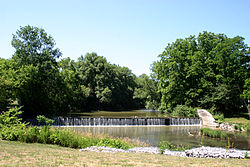
Tonawanda Creek is also part of the Erie Canal, which joins the creek southwest of Lockport and allows canal traffic to proceed into the Niagara River. In its upper reaches, Tonawanda Creek and the Little Tonawanda, which is a tributary, are trout streams.

History

The name Tonawanda (Te-ni-wun-da) [4] or (Ta-na-wan-deh') [5] derives from the Iroquois (Haudenosaunee) language meaning swift water. [4]

Tonawanda Creek flows through the ancient lake bed of Glacial Lake Tonawanda, a prehistoric lake that existed approximately 10,000 years ago at the end of the last ice age; many of the swamp lands surrounding Tonawanda Creek also date back to this lake.

Downstream of Indian Falls, Tonawanda Creek flows through the Tonawanda Indian Reservation, and this is where George Washington made a troop fording across the stream. [5]

When the Erie Canal was first built, the Tonawanda Creek was the source of water for the western section of the Canal.

See also

Related Research Articles

The Erie Canal is a canal that traverses east–west through upstate New York, eastern United States, as part of the cross-state route of the New York State Canal System. It was built to create a navigable water route from the Atlantic Ocean to the Great Lakes Basin, originally stretching for 584 kilometres (363 mi) from the Hudson River at Albany to Lake Erie in Buffalo. Completed in 1825, it was the second-longest canal in the world and greatly enhanced the development and economy of many major cities of New York, including New York City, Albany, Syracuse, Rochester and Buffalo, as well as the United States. This was in part due to the new ease of transporting salt and other necessity goods, and industries that developed around those.

Niagara River River in New York, United States and Ontario, Canada

The Niagara River is a river that flows north from Lake Erie to Lake Ontario. It forms part of the border between the province of Ontario in Canada and the state of New York in the United States. There are differing theories as to the origin of the river's name. According to Iroquoian scholar Bruce Trigger, Niagara is derived from the name given to a branch of the locally residing native Neutral Confederacy, who are described as being called the Niagagarega people on several late-17th-century French maps of the area. According to George R. Stewart, it comes from the name of an Iroquois town called Ongniaahra, meaning "point of land cut in two".

Erie County, New York County in New York, United States

Erie County is a county along the shore of Lake Erie in western New York State. As of the 2020 census, the population was 954,236. The county seat is Buffalo, which makes up about 28% of the county's population. Both the county and Lake Erie were named for the regional Iroquoian language-speaking Erie tribe of Native Americans, who lived in the area before 1654. They were later pushed out by the more powerful Iroquoian nations tribes.

North Tonawanda, New York City in New York, United States

North Tonawanda is a city in Niagara County, New York, United States. The population was 31,568 at the 2010 census. It is part of the Buffalo–Niagara Falls Metropolitan Statistical Area. The city is named after Tonawanda Creek, its south border.

Susquehanna River Major river in the Northeastern United States

The Susquehanna River is a major river located in the Mid-Atlantic region of the United States, overlapping between the lower Northeast and the Upland South. At 444 miles (715 km) long, it is the longest river on the East Coast of the United States. By watershed area, it is the 16th-largest river in the United States, and also the longest river in the early 21st-century continental United States without commercial boat traffic.

Tonawanda Reservation Indian reservation in New York, United States

The Tonawanda Indian Reservation is an Indian reservation of the Tonawanda Seneca Nation located in western New York, United States. The band is a federally recognized tribe and, in the 2010 census, had 693 people living on the reservation. The reservation lies mostly in Genesee County, extending into Erie and Niagara counties. It is bordered by the Towns of Alabama, Pembroke, Newstead, and Royalton.

Tonawanda (city), New York City in New York, United States

Tonawanda is a city in Erie County, New York, United States. The population was 15,130 at the 2010 census. It is at the northern edge of Erie County, south across the Erie Canal from North Tonawanda, east of Grand Island, and north of Buffalo. It is part of the Buffalo-Niagara Falls metropolitan area.

Tonawanda (town), New York Town in New York, United States

Tonawanda is a town in Erie County, New York, United States. As of the 2010 census, the town had a population of 73,567. The town is at the north border of the county and is the northern inner ring suburb of Buffalo. It is sometimes referred to, along with its constituent village of Kenmore, as "Ken-Ton". The town was established in 1836, and up to 1903 it included what is now the city of Tonawanda.

Mohawk River River in the U.S. state of New York

The Mohawk River is a 149-mile-long (240 km) river in the U.S. state of New York. It is the largest tributary of the Hudson River. The Mohawk flows into the Hudson in Cohoes, New York, a few miles north of the city of Albany. The river is named for the Mohawk Nation of the Iroquois Confederacy. It is a major waterway in north-central New York. The largest tributary, the Schoharie Creek, accounts for over one quarter (26.83%) of the Mohawk River's watershed. Another main tributary is the West Canada Creek, which makes up for 16.33% of the Mohawk's watershed.

Genesee River River in New York and Pennsylvania

The Genesee River is a tributary of Lake Ontario flowing northward through the Twin Tiers of Pennsylvania and New York in the United States.

Tonawanda may refer to:

Western New York Region in New York, United States

Western New York (WNY) is the westernmost region of the U.S. state of New York. The eastern boundary of the region is not consistently defined by state agencies or those who call themselves “Western New Yorkers.” Almost all sources agree WNY includes the cities of Buffalo, Niagara Falls, Jamestown, and the surrounding suburbs, as well as the outlying rural areas of the Great Lakes lowlands and Niagara Frontier, and Chautauqua-Alleghany Many would also place Rochester and the Genesee Valley in the region while some would also include the western Finger Lakes within the region. Others would describe the latter three areas as being in a separate Finger Lakes region.

Buffalo River (New York)

The Buffalo River drains a 447-square-mile (1,160 km2) watershed in Western New York state, emptying into the eastern end of Lake Erie at the City of Buffalo. The river has three tributaries: Cayuga Creek, Buffalo Creek, and Cazenovia Creek.

Seneca River (New York) River in Upstate New York

The Seneca River flows 61.6 miles (99.1 km) through the Finger Lakes region of Upstate New York in the United States. The main tributary of the Oswego River – the second largest river flowing into Lake Ontario – the Seneca drains 3,468 square miles (8,980 km2) in parts of fourteen New York counties. The Seneca flows generally east, and is wide and deep with a gentle gradient. Much of the river has been channelized to form part of the Erie Canal.

Millstone River Tributary of the Raritan River in New Jersey, United States

The Millstone River is a 38.6-mile-long (62.1 km) tributary of the Raritan River in central New Jersey in the United States.

Ellicott Creek

Ellicott Creek is a stream in Western New York, United States. It is a tributary of Tonawanda Creek, which in turn flows into the Niagara River.

Cayuga Creek is a small stream in western New York, United States, with stretches in both Erie County and Wyoming County. The creek enters Buffalo Creek in the northwest corner of the Town of West Seneca in Erie County, just upstream from the New York State Thruway crossing. At that point, Buffalo Creek becomes the Buffalo River and flows into Lake Erie near Buffalo, New York.

History of Buffalo, New York

Buffalo is the county seat of Erie County, and the second most populous city in the U.S. state of New York, after New York City. Originating around 1789 as a small trading community inhabited by the Neutral Nation near the mouth of Buffalo Creek, the city, then a town, grew quickly after the opening of the Erie Canal in 1825, with the city at its western terminus. Its position at the eastern end of Lake Erie strengthened the economy, based on grain milling and steel production along the southern shores and in nearby Lackawanna.

Geography of New York (state) State of the United States

The geography of New York state varies widely. Most of New York is dominated by farms, forests, rivers, mountains, and lakes. New York's Adirondack Park is larger than any U.S. National Park in the contiguous United States. Niagara Falls, on the Niagara River as it flows from Lake Erie to Lake Ontario, is a popular attraction. The Hudson River begins near Lake Tear of the Clouds and flows south through the eastern part of the state without draining lakes George or Champlain. Lake George empties at its north end into Lake Champlain, whose northern end extends into Canada, where it drains into the Richelieu River and then the St. Lawrence. Four of New York City's five boroughs are on the three islands at the mouth of the Hudson River: Manhattan Island, Staten Island, and Brooklyn and Queens on Long Island.

Twelve Mile Creek is a waterway located on the Niagara Peninsula in the Regional Municipality of Niagara in Southern Ontario, Canada. Its headwaters are located in the town of Pelham, encompassing some of the most unspoiled and natural areas of Niagara area. The creek's lower reaches flow through urban areas of Thorold and St. Catharines and have been heavily altered by human activity for almost two centuries. The creek was first known as "Ashquasing" by the Mississaugas Indigenous people, the name meaning "that which lies at the end" in the Anishinaabe language.

References

  1. 1 2 3 "Tonawanda Creek". Geographic Names Information System . United States Geological Survey . Retrieved July 17, 2016.
  2. "Tonawanda Creek". Friends of the Buffalo Niagara Rivers. Archived from the original on December 21, 2005. Retrieved July 17, 2016.
  3. "Interesting Facts" (PDF). Town of Pembroke. Retrieved July 17, 2016.
  4. 1 2 Morgan, Lewis Henry; Lloyd, Herbert Marshall (1922). "Book III, Appendix A". League of the Ho-dé-no-sau-nee or Iroquois. Dodd, Mead. p. 129. Retrieved July 17, 2016.
  5. 1 2 "Letters on the Iroquois: Letter XIII". The American Whig Review, Volume 6. Wiley and Putnam. November 1847. p. 488. Retrieved July 17, 2016.