Lockport (city), New York

Last updated

Lockport, New York
Erie Canal and Flight of Five Locks from Canal Street, Lockport, New York - 20210531.jpg
Downtown Lockport with Locks 34 and 35 Below
Nickname: 
The Lock City
Niagara County New York incorporated and unincorporated areas Lockport highlighted.svg
Location in Niagara County and the state of New York
Coordinates: 43°10′11″N78°41′28″W / 43.16972°N 78.69111°W / 43.16972; -78.69111
Country United States
State New York
County Niagara
Government
  Type Mayor-council
   Mayor Michelle Roman (D)
   Common Council
Members' List
Area
[1]
  Total8.45 sq mi (21.87 km2)
  Land8.40 sq mi (21.76 km2)
  Water0.05 sq mi (0.12 km2)
Elevation
614 ft (187 m)
Population
 (2020)
  Total20,876
  Density2,485.24/sq mi (959.58/km2)
Time zone UTC-5 (Eastern (EST))
  Summer (DST) UTC-4 (EDT)
ZIP Codes
14094-14095
Area code 716
FIPS code 36-43082
GNIS feature ID0955783
Website lockportny.gov

Lockport is both a city and the town that surrounds it in Niagara County, New York, United States. The city is the Niagara county seat, with a population of 21,165 according to 2010 census figures, and an estimated population of 20,305 as of 2019. [2]

Contents

Its name derives from a set of Erie Canal locks (Lock Numbers 34 and 35) within the city that were built to allow canal barges to traverse the 60-foot natural drop (18 m) of the Niagara Escarpment. [3] It is part of the Buffalo–Niagara Falls metropolitan area.

History

Lockport 1839 by William Henry Bartlett Lockport bartlett color.jpg
Lockport 1839 by William Henry Bartlett

The New York State Legislature authorized the Erie Canal's construction in April 1816. The route proposed by surveyors was to traverse an area in central Niagara County, New York, which was then "uncivilized" and free of White settlers. At the time, the nearest settlers were in nearby Cold Springs, New York. Following the announcement, land speculators began to buy large plots along and near the proposed route of the canal. By December 1820, when the exact location of the step locks had been determined, the area that would become Lockport was owned by only fifteen men, many of whom were Quakers.

The canal reached Lockport in 1824, but the Flight of Five Locks were not completed until 1825. By 1829, Lockport was an established village. The community was centered on the locks, and consisted mainly of immigrant Scottish and Irish canal workers brought in as labor. The workers remained in Lockport after the completion of the locks, giving the city a heavy Celtic influence still discernible today, especially in the Lowertown and North Lockport neighborhoods.

The city of Lockport was incorporated in 1865. The Erie Canal was supplanted by the larger New York State Barge Canal in 1918, and the famous south "Flight of Five" locks was replaced by two much larger locks E34 and E35. The north "Flight of Five" lock chambers still remain as a spillway.

In recent years,[ when? ] public officials and private businesses have made an effort to promote Lockport history as a regional or national tourist attraction. This includes the completion of the Canal Discovery Center, the Lockport Cave and Underground Boat Ride tour, and the Lockport Locks and Erie Canal Cruises. Local officials are seeking state grants to reconstruct the historic "Flight of Five" and make it a living history site complete with boat rides and reenactors. Published reports state that such a living history site in Lockport, marketed as a day trip from Niagara Falls, could draw thousands of tourists to Lockport each year.

The city has a number of properties on the National Register of Historic Places. They include the Bacon-Merchant-Moss House, Col. William M. and Nancy Ralston Bond House, Chase-Crowley-Keep House, Chase-Hubbard-Williams House, Nathan Comstock Jr. House, Conkey House, Day Peckinpaugh , Dole House, Gibbs House, High and Locust Streets Historic District, Hopkins House, House at 8 Berkley Drive, Lockport Industrial District, Lowertown Historic District, Maloney House, Benjamin C. Moore Mill, Niagara County Courthouse and County Clerk's Office, Thomas Oliver House, Pound–Hitchins House, Stickney House, Union Station, United States Post Office, Peter D. Walter House, Watson House, and White-Pound House. [4] [5]

Lockport's largest employer is General Motors Components, the former Harrison Radiator Corporation, which was founded locally in 1912 and which became a division of General Motors Corporation in 1918. After 10 years of ownership by Delphi Corporation as Delphi Thermal Systems, it returned to General Motors in October 2009. [6]

In 1948, the Lockport Chief of Police denied a permit for a Jehovah's Witnesses minister to preach in a public park using a sound truck. In Saia v. New York , the U.S. Supreme Court struck down the city ordinance as a violation of the First Amendment.

Geography

The current double lift Lockport Lock is left in the distance with the northern Flight of Five to its right. St. Mary's Roman Catholic Church is in the background. The Falls Road Railroad runs above. ErieCanalRRBridge04 1A.jpg
The current double lift Lockport Lock is left in the distance with the northern Flight of Five to its right. St. Mary's Roman Catholic Church is in the background. The Falls Road Railroad runs above.
Original northern five step lock structure crossing the Niagara Escarpment at Lockport now without gates and used as a cascade for excess water. Double
.mw-parser-output .frac{white-space:nowrap}.mw-parser-output .frac .num,.mw-parser-output .frac .den{font-size:80%;line-height:0;vertical-align:super}.mw-parser-output .frac .den{vertical-align:sub}.mw-parser-output .sr-only{border:0;clip:rect(0,0,0,0);clip-path:polygon(0px 0px,0px 0px,0px 0px);height:1px;margin:-1px;overflow:hidden;padding:0;position:absolute;width:1px}
24+1/2-foot-high (7.5 m), 40-foot-wide (12 m) modern locks are to the left which replaced the original southern Flight of Five lock structure. Flight of five at Lockport.JPG
Original northern five step lock structure crossing the Niagara Escarpment at Lockport now without gates and used as a cascade for excess water. Double 24+12-foot-high (7.5 m), 40-foot-wide (12 m) modern locks are to the left which replaced the original southern Flight of Five lock structure.

According to the U.S. Census Bureau, the city has a total area of 8.6 square miles (22.4 km2), of which 8.5 square miles (22.1 km2) is land and 0.1 square miles (0.3 km2) (1.39%) is water. The Erie Canal passes through the center of the city, turning south toward Tonawanda Creek. It climbs the Niagara Escarpment through a series of two modern locks. Originally, a double set of five smaller combined locks were used.

Lockport is at the junction of several major truck routes, including NY Route 78 (Transit Road), NY Route 31, NY Route 77 and NY Route 93. It is 17 miles north of Interstate 90 via NY Route 78. The highest point is the bell tower at 452 High Street, with the street itself being the highest street as measured by frontage above the 650 feet elevation.

Lockport lies in area code 716.

Tourist attractions

Demographics

Historical population
CensusPop.Note
1860 10,871
1870 12,42614.3%
1880 13,5228.8%
1890 16,03818.6%
1900 16,5813.4%
1910 17,9708.4%
1920 21,30818.6%
1930 23,1608.7%
1940 24,3795.3%
1950 25,1333.1%
1960 26,4435.2%
1970 25,399−3.9%
1980 24,844−2.2%
1990 24,426−1.7%
2000 22,279−8.8%
2010 21,165−5.0%
2020 20,876−1.4%
U.S. Decennial Census [9]

At the 2010 census, [10] there were 21,165 people, 9,153 households and 5,172 families residing in the city. There were 10,092 housing units. The racial makeup of the city was 87.5% White, 7.2% Black or African American, 0.5% Native American, 0.5% Asian, 0.02% Pacific Islander, 0.8% from other races, and 3.5% from two or more races. Hispanic or Latino people of any race were 3.2% of the population.

At the 2000 census, there were 9,459 households; 30.5% of households included children under the age of 18, 41.4% were married couples living together, 13.5% had a female householder with no husband present, and 40.7% were non-families. 34.7% of all households were made up of individuals,[ vague ] and 13.3% had someone living alone who was 65 years of age or older. The average household size was 2.33 and the average family size was 3.03.

25.8% of the population were under the age of 18, 8.4% from 18 to 24, 30.6% from 25 to 44, 20.9% from 45 to 64, and 14.3% who were 65 years of age or older. The median age was 36 years. For every 100 females, there were 91.7 males. For every 100 females age 18 and over, there were 87.4 males.

The median household income was $35,228, and the median family income was $44,614. Males had a median income of $35,197 and females $23,944. The per capita income was $19,620. About 11.7% of families and 13.3% of the population were below the poverty line, including 18.9% of those under age 18 and 7.4% of those age 65 or over.

Local politics

The city is governed by a mayor and a city council. The mayor is elected to a four-year term, the aldermen to two-year terms. There are five wards in the city, resulting in five aldermen plus one alderman-at-large, who is elected by the entire city. In 2003,[ needs update ] Michael W. Tucker was elected mayor of the city of Lockport; he was subsequently reelected in 2007 and 2011. However, he resigned in 2014 [11] instead of serving his third four-year term. City of Lockport Common Council President and 2nd Ward Alderwoman Anne McCaffrey replaced Tucker as interim mayor and was sworn in on February 24, 2014. She was later elected to a full four-year term that began in January 2016. [12] She resigned and accepted the position as president and CEO of Eastern Niagara Hospital. [13]

Education

Lockport City School District oversees all local public schools.

DeSales Catholic School [14] is a local private elementary school within the regional Diocese of Buffalo. The school was named after St. Francis de Sales. Previously a high school, it now teaches classes from pre-school through eighth grade.

Notable people

Louis Tiffany stained glass window at the First Presbyterian Church LockportStainedGlass.jpg
Louis Tiffany stained glass window at the First Presbyterian Church

Some people of note who were born in Lockport are: [15]

One of the new steel locks - 24.5-foot (7.5m) lift LockportLock1007.JPG
One of the new steel locks – 24.5-foot (7.5m) lift

Some people of note who have resided in Lockport are:

Notable businesses

See also

Related Research Articles

<span class="mw-page-title-main">Erie Canal</span> Waterway in New York, U.S.

The Erie Canal is a historic canal in upstate New York that runs east–west between the Hudson River and Lake Erie. Completed in 1825, the canal was the first navigable waterway connecting the Atlantic Ocean to the Great Lakes, vastly reducing the costs of transporting people and goods across the Appalachians. In effect, the canal accelerated the settlement of the Great Lakes region, the westward expansion of the United States, and the economic ascendancy of New York State. It has been called "The Nation's First Superhighway."

<span class="mw-page-title-main">Niagara County, New York</span> County in New York, United States

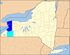
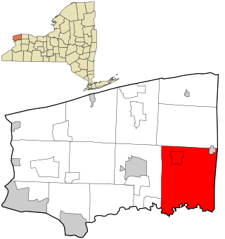
Niagara County is in the U.S. state of New York. As of the 2020 census, the population was 212,666. The county seat is Lockport. The county name is from the Iroquois word Onguiaahra; meaning the strait or thunder of waters.

<span class="mw-page-title-main">Amherst, New York</span> Town in New York, United States

Amherst is a town in Erie County, New York, United States. It is a suburb of Buffalo. As of 2020, the town had a total population of 129,595. This represents an increase from 122,366 as reported in the 2010 census.

<span class="mw-page-title-main">Clarence, New York</span> Town in New York, United States

Clarence is a town and affluent suburb located in the northeastern part of Erie County, New York, United States, northeast of Buffalo. The population was 32,950 according to the 2020 census estimate. This represents an increase of 7.4% from the 2010 census figure. The Clarence census-designated place occupies the southeast part of the town and roughly corresponds to a postal district with ZIP code 14031 and 14221 in the western side which it shares with nearby Williamsville. The town is named in honor of Prince William, Duke of Clarence and St Andrews (1765–1837), the third son of King George III and later king himself, as William IV.

<span class="mw-page-title-main">Cambria, New York</span> Town in New York, United States

Cambria is a town in Niagara County, New York, United States. The population was 5,743 at the 2020 census. Cambria is an early name for Wales.

<span class="mw-page-title-main">Hartland, New York</span> Town in New York, United States

Hartland is a town in Niagara County, New York, United States. The population was 4,117 at the 2010 census. The town is named after Hartland, Vermont, the homeplace of some early settlers.

<span class="mw-page-title-main">North Tonawanda, New York</span> City in New York, United States

North Tonawanda is a city in Niagara County, New York, United States. The population was 31,568 at the 2010 census. It is part of the Buffalo–Niagara Falls Metropolitan Statistical Area. The city is named after Tonawanda Creek, its south border.

<span class="mw-page-title-main">Pendleton, New York</span> Town in New York, United States

Pendleton is a town on the southern edge of Niagara County, New York, United States. It is east of the city of Niagara Falls and southwest of the city of Lockport. The population was 6,397 at the 2010 census.

<span class="mw-page-title-main">Royalton, New York</span> Town in New York, United States

Royalton is a town in Niagara County, New York, United States. The population was 7,660 at the 2010 census.

<span class="mw-page-title-main">Tonawanda (city), New York</span> City in New York, United States

Tonawanda is a city in Erie County, New York, United States. The population was 15,129 at the 2020 census. It is at the northern edge of Erie County, south across the Erie Canal from North Tonawanda, east of Grand Island, and north of Buffalo. It is part of the Buffalo-Niagara Falls metropolitan area.

<span class="mw-page-title-main">Amsterdam (city), New York</span> City in the United States

Amsterdam is a city in Montgomery County, New York, United States. As of the 2020 census, the city had a population of 18,219. The city is named after Amsterdam in the Netherlands.

<span class="mw-page-title-main">Lockport (town), New York</span> Town in New York, United States

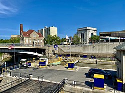
Lockport is a town in Niagara County, New York, United States. The population was 20,529 at the 2010 census. The name is derived from the series of canal locks on the Erie Canal. The locks lift boats from the lowland of Lake Ontario past the Niagara Escarpment.

<span class="mw-page-title-main">Niagara Frontier Transportation Authority</span> Public transit operator in Erie and Niagara Counties, New York

The Niagara Frontier Transportation Authority (NFTA) is a New York State public-benefit corporation responsible for the public transportation oversight of Erie and Niagara counties. The NFTA, as an authority, oversees a number of subsidiaries, including the NFTA Metro bus and rail system, the Buffalo-Niagara International Airport, the Niagara Falls International Airport and NFTA Small Boat Harbor. The NFTA Metro bus and rail system is a multi-modal agency, utilizing various vehicle modes, using the brand names: NFTA Metro Bus, NFTA Metro Rail, NFTA Metrolink and NFTA PAL. In 2022, the system had a ridership of 14,061,700, or about 51,300 per weekday as of the first quarter of 2023.

<span class="mw-page-title-main">New York State Route 31</span> Highway in New York

New York State Route 31 (NY 31) is a state highway that extends for 208.74 miles (335.93 km) across western and central New York in the United States. The western terminus of the route is at an intersection with NY 104 in the city of Niagara Falls. Its eastern terminus is at a traffic circle with NY 26 in Vernon Center, a hamlet within the town of Vernon. Over its routing, NY 31 spans 10 counties and indirectly connects three major urban areas in Upstate New York: Buffalo–Niagara Falls, Rochester, and Syracuse. The route is one of the longest routes in New York State, paralleling two similarly lengthy routes, NY 104 to the north and NY 5 to the south, as well as the Erie Canal, as it proceeds east.

<span class="mw-page-title-main">New York State Route 270</span> State highway in western New York, US

New York State Route 270 (NY 270) is a north–south state highway in western New York in the United States. It runs through rural and wooded areas of the town of Amherst in Erie County and the town of Pendleton in Niagara County. The southern terminus of the route is at an intersection with NY 263 south of the hamlet of Getzville. Its northern terminus is at a junction with NY 31 and NY 93 west of the city of Lockport. The entirety of NY 270 is known as Campbell Boulevard, named after New York State Senator William W. Campbell of the Niagara–Orleans district.

<span class="mw-page-title-main">New York State Route 31E</span> State highway in western New York, US

New York State Route 31E (NY 31E) is a 5.29-mile (8.51 km) state highway located in western New York in the United States. It serves as a northerly alternate route of NY 31 between the village of Middleport in eastern Niagara County and the nearby village of Medina in Orleans County. NY 31E connects to NY 31 at each end by way of a short overlap with NY 271 in Middleport. Most of NY 31E parallels the Erie Canal, and parts of the route run adjacent to the waterway. Outside of the two villages at each end, NY 31E traverses mostly rural areas of the towns of Royalton and Ridgeway.

<span class="mw-page-title-main">International Railway (New York–Ontario)</span> Former urban transit company in Buffalo, NY

The International Railway Company (IRC) was a transportation company formed in a 1902 merger between several Buffalo-area interurban and street railways. The city railways that merged were the West Side Street Railway, the Crosstown Street Railway and the Buffalo Traction Company. The suburban railroads that merged included the Buffalo & Niagara Electric Street Railway, and its subsidiary the Buffalo, Lockport & Olcott Beach Railway; the Buffalo, Depew & Lancaster Railway; and the Niagara Falls Park & River Railway. Later the IRC acquired the Niagara Gorge Railroad (NGRR) as a subsidiary, which was sold in 1924 to the Niagara Falls Power Company. The NGRR also leased the Lewiston & Youngstown Frontier Railroad.

<span class="mw-page-title-main">Lowertown Historic District (Lockport, New York)</span> Historic district in New York, United States

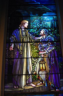
Lowertown Historic District is a national historic district located at Lockport in Niagara County, New York. The district is predominantly residential in nature, with some commercial structures and warehouses. The mose elegant homes are along Market Street, east of Chapel Street, facing the Erie Canal. Notable structures in this district include the Western Block Company Warehouse, a 2+12-story stone structure built before 1855; Lockport Bank Building built in 1829, and located at 315-319 Market Street; Washington Hunt House, built in 1831 and home to New York Governor Washington Hunt, and located at 363 Market Street; the former Christ Episcopal Church at 425 Market Street; and the Vine Street School, an Italianate style one-room school built in 1864.

<span class="mw-page-title-main">Lyons, New York</span> Town in New York, United States

Lyons is a town in Wayne County, New York, United States. The population was 5,682 at the 2010 census. It is named after Lyon, France.

References

Notes

  1. "ArcGIS REST Services Directory". United States Census Bureau. Retrieved September 20, 2022.
  2. "Population and Housing Unit Estimates" . Retrieved May 21, 2020.
  3. Gannett, Henry (1905). The Origin of Certain Place Names in the United States. U.S. Government Printing Office. p.  189.
  4. "National Register Information System". National Register of Historic Places . National Park Service. July 9, 2010.
  5. "National Register of Historic Places Listings". Weekly List of Actions Taken on Properties: 11/17/14 through 11/21/14. National Park Service. November 28, 2014. Archived from the original on March 22, 2015.
  6. "BUSINESS: Delphi emerges from bankruptcy » Delphi » Lockport Union-Sun & Journal Online". Archived from the original on January 4, 2013. Retrieved December 22, 2009.
  7. "Lockport Express". Archived from the original on March 15, 2017. Retrieved March 17, 2017.
  8. D'onofrio, John (March 12, 2017). "A win-win for Lockport and Cornerstone Arena". Lockport Union-Sun & Journal. Retrieved June 13, 2023.
  9. "Census of Population and Housing". Census.gov. Retrieved June 4, 2015.
  10. "U.S. Census website". United States Census Bureau . Retrieved January 31, 2008.
  11. "Lockport Mayor Announces sudden resignation". Business First- Buffalo. February 21, 2014. Retrieved February 22, 2014.
  12. http://www.lockportny.gov/government/mayor/ Lockportny.gov. Retrieved February 26, 2018.
  13. "Anne McCaffrey to Resign as Mayor of Lockport | Lockport, NY". July 26, 2018.
  14. DeSales Catholic School
  15. Most biographical sources simply refer to Lockport without specifying the City or the surrounding Town; persons on this list may be associated with either the City or the Town of Lockport.
  16. "Birdsill Holly 1820-1894". Holly Manufacturing Company History. Lockport Cave & Underground Boat Ride. Retrieved December 30, 2015.
  17. Chauncey Olcott
  18. General Motors
  19. Palace Theatre
  20. "About | Historic Palace Theatre | Located in the Heart of Lockport, NY". Lockport Palace Theater. Retrieved June 14, 2021.
  21. 1 2 3 "Palace Theatre in Lockport, NY - Cinema Treasures". cinematreasures.org. Retrieved June 14, 2021.
  22. 1 2 "Palace Theatre History". Lockport Palace Theater. Retrieved June 14, 2021.
  23. "Historic Palace Theatre reopens in downtown Lockport". Niagara Frontier Publications. Retrieved June 14, 2021.

Further reading