Mayville, New York

Last updated

Mayville, New York
Chautauqua County Courthouse Old and New, Mayville, New York - 20210501.jpg
Chautauqua County Courthouse, May 2021
USA New York location map.svg
Red pog.svg
Mayville
Location within the state of New York
Coordinates: 42°15′5″N79°30′0″W / 42.25139°N 79.50000°W / 42.25139; -79.50000
Country United States
State New York
County Chautauqua
Town Chautauqua
Area
[1]
  Total2.02 sq mi (5.23 km2)
  Land2.02 sq mi (5.22 km2)
  Water0.00 sq mi (0.01 km2)
Elevation
1,453 ft (443 m)
Population
 (2020)
  Total1,442
  Density715.28/sq mi (276.19/km2)
Time zone UTC-5 (Eastern (EST))
  Summer (DST) UTC-4 (EDT)
ZIP code
14757
Area code 716
FIPS code 36-46239
GNIS feature ID0956714
Website villageofmayville.com

Mayville is a village in Chautauqua County, New York, United States. The population was 1,477 at the 2020 census, [2] 13.7% less than in the 2010 census. Mayville is in the town of Chautauqua and is the county seat of Chautauqua County. [3] The village and town offices share a building on Main Street, directly across from the Chautauqua County courthouse.

Contents

Elisabeth (May) Busti, 1759-1822 eponym of Mayville, New York Elizabeth May Busti.jpg
Elisabeth (May) Busti, 1759-1822 eponym of Mayville, New York

History

The Holland Land Company anticipated establishing a village located at the eastern end of the Old Portage Road between Lake Erie and Chautauqua Lake. In 1804, the area was surveyed by William Peacock. In 1805, the village was named Mayville in honor of Elisabeth Busti (née May), wife of Paul Busti, Agent General of the Holland Land Company. [4] [5]

The 1808 legislation establishing the formation of Chautauqua County required the appointment of a committee to locate the county seat. Gov. Daniel D. Tompkins selected Jonas Williams (Batavia), Isaac Sutherland (Batavia) and Asa Ransom (Clarence) based on the recommendations of Joseph Ellicott, Resident Land Agent for the Holland Land Company in Batavia. The committee designated Mayville as the county seat, rubberstamping the Holland Land Company plan. [6] [7] [8]

In 1804, Alexander McIntyre of Meadville, Pennsylvania became the first land owner in the future village. The Holland Land Company established a sales office in Mayville in 1810 with William Peacock as sub-agent. [9]

William Peacock, 1780-1877 William Peacock-Young 1875.jpg
William Peacock, 1780-1877

The village of Mayville was incorporated in 1830. In 1836, local residents rioted against the Holland Land Company and broke into its office, destroying furniture and papers.

The Pennsylvania Railroad built a train station and pier on the shores of Chautauqua Lake at Mayville. This station was on a PRR route from Pittsburgh to Dunkirk to Buffalo route. [10] The Mayville station, along with the Jamestown boat landing at the south end of the lake, was the main mode of transportation to the rest of the communities around Chautauqua Lake via the large fleet of steamboats operating before the interurban lines were constructed. [11] The Chautauqua Traction Company served the communities on the western side of the lake; and the Jamestown, Westfield and Northwestern Railroad was the interurban serving the east side of the lake. In modern times the steamboat Chautauqua Belle still operates out of Mayville, running between Point Chautauqua, Chautauqua Institution, and the vessel's home port in Mayville.
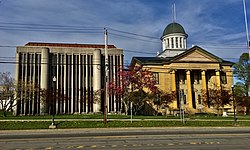
The Pennsylvania Railroad Station was listed on the National Register of Historic Places in 1993. [12] The Point Chautauqua Historic District was listed in 1996. [12]

Geography

Route 394 along the west side of Chautauqua Lake in Mayville 394chautauqualake.jpg
Route 394 along the west side of Chautauqua Lake in Mayville

Mayville is located near the geographic center of the town of Chautauqua at 42°15′5″N79°30′0″W / 42.25139°N 79.50000°W / 42.25139; -79.50000 (42.251402, -79.500015). [13] It is situated at the northwest end of Chautauqua Lake.

Mayville is at the junction of New York State Routes 394 and 430, 7 miles (11 km) south of the New York State Thruway (Interstate 90) at Westfield.

Mayville is the nearest village to the Chautauqua Institution, which draws thousands of visitors during the summer months. Businesses in the village do a brisk tourist business both with Chautauquans and with visitors to cottages and resorts on the east and west sides of the lake.

According to the United States Census Bureau, the village has a total area of 1.99 square miles (5.16 km2), all land. [14]

Climate

Mayville has a humid continental climate (Köppen Dfb), typical of southwestern New York state. Winters are cold and snowy, while summers are warm and humid.

Climate data for Mayville, NY
MonthJanFebMarAprMayJunJulAugSepOctNovDecYear
Average high °F (°C)34
(1)
36
(2)
46
(8)
57
(14)
69
(21)
78
(26)
82
(28)
79
(26)
72
(22)
61
(16)
49
(9)
39
(4)
59
(15)
Average low °F (°C)19
(−7)
19
(−7)
27
(−3)
37
(3)
49
(9)
58
(14)
63
(17)
62
(17)
55
(13)
45
(7)
35
(2)
25
(−4)
41
(5)
Average precipitation inches (mm)2.46
(62)
2.40
(61)
2.98
(76)
3.39
(86)
3.65
(93)
4.37
(111)
4.15
(105)
4.45
(113)
5.30
(135)
4.75
(121)
4.42
(112)
3.51
(89)
45.83
(1,164)
Source: The Weather Channel [15]

Demographics

Historical population
CensusPop.Note
1870 701
1880 1,05149.9%
1890 1,16410.8%
1900 943−19.0%
1910 1,12219.0%
1920 1,2077.6%
1930 1,2735.5%
1940 1,3546.4%
1950 1,49210.2%
1960 1,6198.5%
1970 1,567−3.2%
1980 1,6263.8%
1990 1,6360.6%
2000 1,7567.3%
2010 1,711−2.6%
2020 1,477−13.7%
2021 (est.)1,468 [2] −0.6%
U.S. Decennial Census [16]

As of the census [17] of 2000, there were 1,756 people, 686 households, and 399 families residing in the village. The population density was 875.0 inhabitants per square mile (337.8/km2). There were 860 housing units at an average density of 428.5 per square mile (165.4/km2). The racial makeup of the village was 93.85% White, 3.64% African American, 0.51% Native American, 0.51% Asian, 0.17% from other races, and 1.31% from two or more races. Hispanic or Latino of any race were 1.59% of the population.

There were 686 households, out of which 27.0% had children under the age of 18 living with them, 44.9% were married couples living together, 9.5% had a female householder with no husband present, and 41.8% were non-families. 36.6% of all households were made up of individuals, and 16.8% had someone living alone who was 65 years of age or older. The average household size was 2.22 and the average family size was 2.92.

In the village, the population was spread out, with 21.8% under the age of 18, 10.1% from 18 to 24, 29.8% from 25 to 44, 22.2% from 45 to 64, and 16.1% who were 65 years of age or older. The median age was 38 years. For every 100 females, there were 114.4 males. For every 100 females age 18 and over, there were 118.3 males.

The median income for a household in the village was $32,250, and the median income for a family was $45,595. Males had a median income of $30,574 versus $24,028 for females. The per capita income for the village was $16,561. About 5.5% of families and 10.2% of the population were below the poverty line, including 10.5% of those under age 18 and 8.4% of those age 65 or over.

Notable people

Related Research Articles

<span class="mw-page-title-main">Chautauqua County, New York</span> County in New York

Chautauqua County is the westernmost county in the U.S. state of New York. As of the 2020 census, the population was 127,657. Its county seat is Mayville, and its largest city is Jamestown. Its name is believed to be the lone surviving remnant of the Erie language, a tongue lost in the 17th century Beaver Wars; its meaning is unknown and a subject of speculation. The county was created in 1808 and organized in 1811.

<span class="mw-page-title-main">Wyoming County, New York</span> County in New York, United States

Wyoming County is a county in the U.S. state of New York in the state's western area. As of the 2020 census, the population was 40,531. The county seat is Warsaw. The name is modified from a Lenape (Delaware) Native American word meaning "broad bottom lands". Wyoming County was formed from Genesee County in 1841. Wyoming County is one of New York's mostly agricultural counties. With an estimated 47,500 dairy cows in the county, there are more cattle in Wyoming County than people.

<span class="mw-page-title-main">Dayton, New York</span> Town in New York, United States

Dayton is a town in Cattaraugus County, New York, United States. The population was 1,689 at the 2020 census. The town is on the western border of Cattaraugus County.

<span class="mw-page-title-main">Bemus Point, New York</span> Village in New York, United States

Bemus Point is a village in Chautauqua County, New York, United States. The village is within the town of Ellery and is located along the eastern shore of Chautauqua Lake. The population was 312 at the 2020 census.

<span class="mw-page-title-main">Busti, New York</span> Town in New York, United States

Busti is a town in Chautauqua County, New York, United States. The population was 7,521 at the 2020 census. The town is named after Paul Busti, an official of the Holland Land Company, but its pronunciation uses a long i sound at the end, a frequent alteration in the names of several upstate New York towns. It has frequently been noted on lists of unusual place names.

Cassadaga is a village in Chautauqua County, New York, United States. The village is located within the northeast corner of the town of Stockton, east of the hamlet of Stockton, south of and immediately adjacent to Lily Dale in the town of Pomfret, and north of the village of Sinclairville. As of the 2020 census, the population of Cassadaga was 569.

<span class="mw-page-title-main">Chautauqua, New York</span> Town in New York, United States

Chautauqua is a town and lake resort community in Chautauqua County, New York. The population was 4,017 at the 2020 census. The town is named after Chautauqua Lake. It is the home of the Chautauqua Institution and the birthplace of the Chautauqua movement.

<span class="mw-page-title-main">Ellicott, New York</span> Town in New York, United States

Ellicott is a town in Chautauqua County, New York, United States. The population was 8,771 at the 2020 census. The town is named after Joseph Ellicott, an agent of the Holland Land Company.

<span class="mw-page-title-main">Falconer, New York</span> Village in New York, United States

Falconer is a village in Chautauqua County, New York, United States. The population was 2,284 at the 2020 census. Falconer is within the town of Ellicott and is on the eastern edge of the city of Jamestown.

<span class="mw-page-title-main">Harmony, New York</span> Town in New York, United States

Harmony is a town in Chautauqua County, New York, United States. The population was 2,108 at the 2020 census. The town is on the south border of the county and southwest of Jamestown.

<span class="mw-page-title-main">Jamestown, New York</span> City in western New York, United States

Jamestown is a city in southern Chautauqua County, in the U.S. state of New York. The population was 28,712 at the 2020 census. Situated between Lake Erie to the north and the Allegheny National Forest to the south, Jamestown is the largest population center in the county. Nearby Chautauqua Lake is a freshwater resource used by fishermen, boaters, and naturalists.

<span class="mw-page-title-main">Kiantone, New York</span> Town in New York, United States

Kiantone is a town in Chautauqua County, New York, United States. As of the 2020 census, the town had a population of 1,388. The town is immediately south of Jamestown and is at the south border of the county.

Silver Creek is a village in the town of Hanover in Chautauqua County, New York, United States. As of the 2020 census, the village had a population of 2,637. Silver Creek is named after a small creek which runs through the village. It is on the shore of Lake Erie.

<span class="mw-page-title-main">Sinclairville, New York</span> Village in New York, United States

Sinclairville is a village in Chautauqua County, New York, United States. The population was 578 at the 2020 census. The village is named after Major Samuel Sinclear, its founder. Sinclairville is north of Jamestown and is on the border of the towns of Charlotte and Gerry.

<span class="mw-page-title-main">Cherry Creek, New York</span> Town in New York, United States

Cherry Creek is a town in Chautauqua County, New York, United States. The population was 1,036 at the 2020 census. The name is derived from that of a small stream that flows through the town amid many cherry trees.

<span class="mw-page-title-main">Ripley, New York</span> Town in New York, United States

Ripley is a town on Lake Erie in the westernmost part of Chautauqua County, New York, United States. The population was 2,310 at the time of the 2020 census. The town was named after Eleazer Wheelock Ripley, a general in the War of 1812. There are no incorporated villages in the town, but there is one census-designated place: the hamlet of Ripley. The town is perhaps best known as being the western end of the New York State Thruway.

Lakewood is a village in Chautauqua County, New York, United States. The population was 2,993 at the 2020 census. The village is in the northern part of the town of Busti.

<span class="mw-page-title-main">New York State Route 430</span> State highway in Chautauqua County, New York, US

New York State Route 430 (NY 430) is a state highway located entirely within Chautauqua County, New York, in the United States. Its western terminus is located at the Pennsylvania state line near the hamlet of Findley Lake in the town of Mina. The eastern terminus is located in the city of Jamestown at a junction with NY 60 and NY 394. NY 430 is ceremoniously designated as the Senator Jess J. Present Memorial Highway in honor of Jess Present, a New York State Senator from Jamestown.

<span class="mw-page-title-main">New York State Route 474</span> State highway in Chautauqua County, New York, US

New York State Route 474 (NY 474) is a state highway located entirely within Chautauqua County in the westernmost corner of New York in the United States. It begins at the section of the Pennsylvania state line that runs north–south and runs eastward, initially paralleling the state line before taking a more northeasterly alignment toward Chautauqua Lake. The route ends adjacent to the lake at a junction with NY 394 in the town of Busti. NY 474 was originally designated as New York State Route 74 in 1930 before being renumbered to NY 474 on July 1, 1972. The route continues westward into Pennsylvania as Pennsylvania Route 474 (PA 474), which was assigned in the 1980s.

<span class="mw-page-title-main">Batavia, New York</span> City in New York, United States

Batavia is a city in and the county seat of Genesee County, New York, United States. It is near the center of the county, surrounded by the Town of Batavia, which is a separate municipality. Batavia's population as of the 2020 census was 15,600. The name Batavia is Latin for the Betuwe region of the Netherlands, and honors early Dutch land developers. In 2006, a national magazine, Site Selection, ranked Batavia third among the nation's micropolitans based on economic development. The New York State Thruway passes north of the city. Genesee County Airport (GVQ) is also north of the city.

References

  1. "ArcGIS REST Services Directory". United States Census Bureau. Retrieved September 20, 2022.
  2. 1 2 Bureau, US Census. "City and Town Population Totals: 2020-2021". Census.gov. US Census Bureau. Retrieved July 4, 2022.
  3. "Find a County". National Association of Counties. Archived from the original on May 31, 2011. Retrieved June 7, 2011.
  4. Safran, Franciska K. (1983) William Peacock, Holland Land Company Subagent in Chautauqua County, New York. Fredonia, N.Y.: Thesis, pp. 24-25.
  5. Magnani, Ferdinando (January 1926). "Paul Busti and the Holland Land Co.: An Historical Vindication". Il Carroccio (New York). 23: 38. hdl:2027/mdp.39015073737325.
  6. Chazanof, William (1970). Joseph Ellicott and the Holland Land Company: The Opening of Western New York. Syracuse University Press. p. 111. ISBN   9781684450022.
  7. New York [State] (1806). Laws of New York, 31st Session, Chapter 40. p. 266.
  8. Young, Andrew W. (1875). History of Chautauqua County, New York, from its first settlement to the present time; with numerous biographical and family sketches. Printing House of Matthews & Warren. p. 77. hdl:2027/coo1.ark:/13960/t4gm8sj24.
  9. Edson, Obed (1891). Dilley, Butler F. (ed.). History of Chautauqua County. Gresham. p. 209. hdl:2027/uc2.ark:/13960/t31265b2d.
  10. "Pennsylvania Railroad, Table 160". Official Guide of the Railways. National Railway Publication Company. 78 (12). May 1946.
  11. "The Jamestown Street Railway Trolley Car #93 Restoration Project". jamestowntrolley.org.
  12. 1 2 "National Register Information System". National Register of Historic Places . National Park Service. March 13, 2009.
  13. "US Gazetteer files: 2010, 2000, and 1990". United States Census Bureau. February 12, 2011. Retrieved April 23, 2011.
  14. "Geographic Identifiers: 2010 Demographic Profile Data (G001): Mayville village, New York". U.S. Census Bureau, American Factfinder. Archived from the original on February 12, 2020. Retrieved November 10, 2014.
  15. "Monthly Averages for Mayville, NY". Weather.com. 2010. Retrieved November 18, 2010.[ permanent dead link ]
  16. "Census of Population and Housing". Census.gov. Retrieved June 4, 2016.
  17. "U.S. Census website". United States Census Bureau . Retrieved January 31, 2008.