Ellicott, New York | |
|---|---|
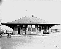 Falconer Station | |
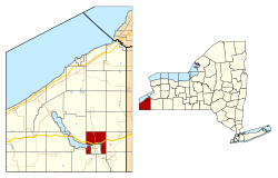 Location within Chautauqua County and New York state | |
 Ellicott  Ellicott | |
| Coordinates: 42°7′10″N79°14′34″W / 42.11944°N 79.24278°W | |
| Country | United States |
| State | New York |
| County | Chautauqua |
| Government | |
| • Type | Town Council |
| • Town Supervisor | Janet Bowman (R) |
| • Town Council | Members' List |
| Area | |
• Total | 30.48 sq mi (78.93 km2) |
| • Land | 30.45 sq mi (78.86 km2) |
| • Water | 0.023 sq mi (0.06 km2) |
| Elevation | 1,404 ft (428 m) |
| Population | |
• Total | 8,771 |
| 8,708 | |
| • Density | 277.4/sq mi (107.11/km2) |
| Time zone | UTC-5 (Eastern (EST)) |
| • Summer (DST) | UTC-4 (EDT) |
| ZIP Codes | |
| FIPS code | 36-013-23998 |
| GNIS feature ID | 0978933 |
| Website | www |
Ellicott is a town in Chautauqua County, New York, United States. The population was 8,771 at the 2020 census. [2] The town is named after Joseph Ellicott, an agent of the Holland Land Company.
Contents
- History
- Geography
- Adjacent towns and areas
- Demographics
- Communities and locations in Ellicott
- Special mentions
- References
- External links
The town of Ellicott is centrally located in the county, lying on the eastern edge of Chautauqua Lake and surrounding the city of Jamestown on the east, north and west.
