Cherry Creek (hamlet), New York

Last updated
Cherry Creek, New York
Hamlet and CDP
CherryCreekLibrary.jpg
Cherry Creek Library
USA New York location map.svg
Red pog.svg
Cherry Creek
Location within the state of New York
Coordinates: 42°17′41″N79°5′50″W / 42.29472°N 79.09722°W / 42.29472; -79.09722
Country United States
State New York
County Chautauqua
Town Cherry Creek
Area
[1]
  Total1.36 sq mi (3.53 km2)
  Land1.36 sq mi (3.53 km2)
  Water0.00 sq mi (0.00 km2)
Elevation
1,302 ft (397 m)
Population
 (2020)
  Total409
  Density300.29/sq mi (115.91/km2)
Time zone UTC-5 (Eastern (EST))
  Summer (DST) UTC-4 (EDT)
ZIP code
14723
Area code 716
FIPS code 36-15187
GNIS feature ID0946509

Cherry Creek is a hamlet (and census-designated place) [2] in Chautauqua County, New York, United States. The population was 461 at the 2010 census, when it was an incorporated village. [3] The hamlet is within the town of Cherry Creek near the east border of the county. It is located on New York State Route 83 and a stream called Cherry Creek.

Contents

History

The hamlet is the site of the earliest settlement of the town, in 1815. The settlement got its name from a cherry tree planted by Holland Land Company surveyor Joshua Bentley to mark the center of the new town. [4] It was formally incorporated as a village in 1893. On February 2, 2017, residents of the village voted 70 to 32 in favor of dissolving into the surrounding town of Cherry Creek. [5] The village was dissolved on December 31, 2017. [6]

Geography

Cherry Creek is located in eastern Chautauqua County at 42°17′40″N79°5′50″W / 42.29444°N 79.09722°W / 42.29444; -79.09722 (42.294654, -79.097353), [7] east of the geographic center of the town of Cherry Creek. A stream by the same name flows east through the hamlet towards Conewango Creek, which in turn is a tributary of the Allegheny River and part of the Mississippi River basin.

According to the United States Census Bureau, the village in the 2010 census has a total area of 1.4 square miles (3.5 km2), all land. [3]

Demographics

Historical population
CensusPop.Note
1880 448
1890 67650.9%
1900 7013.7%
1910 606−13.6%
1920 527−13.0%
1930 5392.3%
1940 529−1.9%
1950 63119.3%
1960 6492.9%
1970 6581.4%
1980 6772.9%
1990 539−20.4%
2000 5512.2%
2010 461−16.3%
2020 409−11.3%
U.S. Decennial Census [8]

As of the census [9] of 2000, there were 551 people, 198 households, and 156 families residing in the village. The population density was 404.8 inhabitants per square mile (156.3/km2). There were 222 housing units at an average density of 163.1 per square mile (63.0/km2). The racial makeup of the village was 96.91% White, 0.18% Black or African American, 0.36% Native American, 0.36% Asian, 0.18% Pacific Islander, 0.91% from other races, and 1.09% from two or more races. Hispanic or Latino of any race were 1.27% of the population.

There were 198 households, out of which 40.4% had children under the age of 18 living with them, 52.5% were married couples living together, 16.2% had a female householder with no husband present, and 21.2% were non-families. 15.7% of all households were made up of individuals, and 7.6% had someone living alone who was 65 years of age or older. The average household size was 2.78 and the average family size was 3.03.

In the village, the population was spread out, with 31.2% under the age of 18, 6.5% from 18 to 24, 29.9% from 25 to 44, 22.1% from 45 to 64, and 10.2% who were 65 years of age or older. The median age was 36 years. For every 100 females, there were 94.0 males. For every 100 females age 18 and over, there were 96.4 males.

The median income for a household in the village was $31,528, and the median income for a family was $32,500. Males had a median income of $31,406 versus $24,038 for females. The per capita income for the village was $15,358. About 15.9% of families and 18.3% of the population were below the poverty line, including 34.9% of those under age 18 and none of those age 65 or over.

Related Research Articles

<span class="mw-page-title-main">Apple River, Illinois</span> Village in Illinois, United States

Apple River is a village in Jo Daviess County, Illinois, United States. The population was 366 at the 2010 census, down from 379 in 2000.

Conewango is a town in Cattaraugus County, New York, United States. The population was 1,794 at the 2020 census. The town is named after a creek which flows through the town.

<span class="mw-page-title-main">Dayton, New York</span> Town in New York, United States

Dayton is a town in Cattaraugus County, New York, United States. The population was 1,689 at the 2020 census. The town is on the western border of Cattaraugus County.

East Randolph is a hamlet, census-designated place, and former village in Cattaraugus County, New York, United States. The population was 620 at the 2010 census. East Randolph is adjacent to the northeast part of the former village of Randolph and is mostly within the town of Randolph, with a small part inside the town of Conewango. Their area code is 716.

Leon is a town in Cattaraugus County, New York. The population was 1,253 at the 2020 census. The name is derived from the former Kingdom of León in Spain, though it is pronounced like the American first name, "LEE-un". The town is on the western border of the county, northwest of the city of Salamanca.

<span class="mw-page-title-main">South Dayton, New York</span> Village in New York, United States

South Dayton is a village in Cattaraugus County, New York, United States. The population was 564 at the 2020 census. The village lies within the town of Dayton by the southwest corner of the town and less than a mile from the border of Chautauqua County.

<span class="mw-page-title-main">Busti, New York</span> Town in New York, United States

Busti is a town in Chautauqua County, New York, United States. The population was 7,521 at the 2020 census. The town is named after Paul Busti, an official of the Holland Land Company, but its pronunciation uses a long i sound at the end, a frequent alteration in the names of several upstate New York towns. It has frequently been noted on lists of unusual place names.

<span class="mw-page-title-main">Charlotte, New York</span> Town in New York, United States

Charlotte is a town in Chautauqua County, New York, United States. As of the 2020 census, the town population was 1,521. Charlotte is centrally located in the county, north of Jamestown and south of Dunkirk.

<span class="mw-page-title-main">Ellicott, New York</span> Town in New York, United States

Ellicott is a town in Chautauqua County, New York, United States. The population was 8,771 at the 2020 census. The town is named after Joseph Ellicott, an agent of the Holland Land Company.

<span class="mw-page-title-main">Falconer, New York</span> Village in New York, United States

Falconer is a village in Chautauqua County, New York, United States. The population was 2,284 at the 2020 census. Falconer is within the town of Ellicott and is on the eastern edge of the city of Jamestown.

<span class="mw-page-title-main">Forestville, New York</span> Hamlet and CDP in New York, United States

Forestville is a hamlet in Chautauqua County, New York, United States. The population was 697 at the 2010 census. The hamlet is within the town of Hanover and in the northeast part of the county. It was an incorporated village from 1848 to 2016.

<span class="mw-page-title-main">Gerry, New York</span> Town in New York, United States

Gerry is a town in Chautauqua County, New York, United States. The population was 1,789 at the 2020 census. The town is named after Elbridge Gerry, the fifth Vice President of the United States. The town is centrally located in the county and is north of Jamestown.

<span class="mw-page-title-main">Harmony, New York</span> Town in New York, United States

Harmony is a town in Chautauqua County, New York, United States. The population was 2,108 at the 2020 census. The town is on the south border of the county and southwest of Jamestown.

<span class="mw-page-title-main">North Harmony, New York</span> Town in New York, United States

North Harmony is a town in Chautauqua County, New York, United States. The population was 2,182 at the 2020 census. The town is on the west side of Chautauqua Lake. The shore of the lake is the location of many summer resort communities.

<span class="mw-page-title-main">Sheridan, New York</span> Town in New York, United States

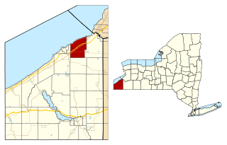
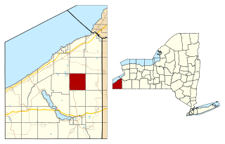
Sheridan is a town in Chautauqua County, New York, United States. The population was 2,563 at the 2020 census. The town is on the county's northern border, east of Dunkirk.

<span class="mw-page-title-main">Sinclairville, New York</span> Village in New York, United States

Sinclairville is a village in Chautauqua County, New York, United States. The population was 578 at the 2020 census. The village is named after Major Samuel Sinclear, its founder. Sinclairville is north of Jamestown and is on the border of the towns of Charlotte and Gerry.

<span class="mw-page-title-main">Villenova, New York</span> Town in New York, United States

Villenova is a town in Chautauqua County, New York, United States. The population was 1,053 at the 2020 census. The town is on the eastern border of the county and is southeast of Dunkirk.

Randolph is a town in Cattaraugus County, New York, United States. The population was 2,470 at the 2020 census. The town was named after Randolph, Vermont.

<span class="mw-page-title-main">Cherry Creek, New York</span> Town in New York, United States

Cherry Creek is a town in Chautauqua County, New York, United States. The population was 1,036 at the 2020 census. The name is derived from that of a small stream that flows through the town amid many cherry trees.

<span class="mw-page-title-main">Arkwright, New York</span> Town in New York, United States

Arkwright is a town in Chautauqua County, New York, United States. As of the 2020 census, the town population was 1,000. The town is named after Richard Arkwright, the inventor of a spinning device.

References

  1. "ArcGIS REST Services Directory". United States Census Bureau. Retrieved September 20, 2022.
  2. "State of New York Census Designated Places - Current/BAS20 - Data as of January 1, 2019". tigerweb.geo.census.gov. Retrieved 2020-02-24.
  3. 1 2 "Geographic Identifiers: 2010 Demographic Profile Data (G001): Cherry Creek village, New York". U.S. Census Bureau, American Factfinder. Archived from the original on February 12, 2020. Retrieved November 10, 2014.
  4. Sommer, Mark (February 5, 2017). "Bid farewell to Cherry Creek, a farming village that will exist no more". The Buffalo News . Retrieved February 5, 2017.
  5. Anderson, Dale (2 February 2017). "Cherry Creek votes to dissolve village". The Buffalo News .
  6. "NYSDOS Division of Local Government Services". www.dos.ny.gov. Archived from the original on 2013-07-20.
  7. "US Gazetteer files: 2010, 2000, and 1990". United States Census Bureau. 2011-02-12. Retrieved 2011-04-23.
  8. "Census of Population and Housing". Census.gov. Retrieved June 4, 2015.
  9. "U.S. Census website". United States Census Bureau . Retrieved 2008-01-31.