Sunset Bay, New York

Last updated
Sunset Bay, New York
Cattaraugus Creek mouth Lake Erie.jpg
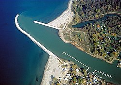
The mouth of the Cattaraugus Creek as seen from overhead. At bottom is the community of Sunset Bay; at top is Snyder Beach on the Cattaraugus Reservation.
USA New York location map.svg
Red pog.svg
Sunset
Bay
Location within the state of New York
Coordinates: 42°33′38″N79°7′54″W / 42.56056°N 79.13167°W / 42.56056; -79.13167 Coordinates: 42°33′38″N79°7′54″W / 42.56056°N 79.13167°W / 42.56056; -79.13167
Country United States
State New York
County Chautauqua
Town Hanover
Area
[1]
  Total0.71 sq mi (1.83 km2)
  Land0.66 sq mi (1.72 km2)
  Water0.04 sq mi (0.11 km2)
Elevation
580 ft (180 m)
Population
 (2020)
  Total470
  Density708.90/sq mi (273.60/km2)
Time zone UTC-5 (Eastern (EST))
  Summer (DST) UTC-4 (EDT)
Area code 716
FIPS code 36-72246
GNIS feature ID0966831

Sunset Bay is a hamlet and census-designated place (CDP) in the town of Hanover in Chautauqua County, New York, United States. The population was 660 at the 2010 census. [2]

Contents

Sunset Bay is adjacent to the Cattaraugus Indian Reservation. On the reservation, adjacent to Sunset Bay, was previously home to a community of approximately 80 non-native residents who leased vacation homes. The Seneca Nation in 2012 declared the longstanding presence of the non-native residents an "illegal occupation" and drove them out of Sunset Bay. [3]

Geography

Sunset Bay is located on the shore of Lake Erie in the northernmost point of the town of Hanover and of Chautauqua County. It is bordered on the northeast by Cattaraugus Creek, which enters Lake Erie just north of an embayment called Sunset Bay. U.S. Route 20 and New York State Route 5 pass through the community as Main Road. Just east of the community is a short connector road from US 20/NY 5 to Exit 58 on the New York State Thruway (Interstate 90). The city of Dunkirk is 12 miles (19 km) to the southwest of Sunset Bay, and Buffalo is 29 miles (47 km) to the northeast.

The nature of Cattaraugus Creek and its volatility leaves the hamlet prone to frequent flooding, especially in the spring.

According to the United States Census Bureau, Sunset Bay has a total area of 0.69 square miles (1.8 km2), of which 0.66 square miles (1.7 km2) is land and 0.04 square miles (0.1 km2), or 6.27%, is water. [2]

Demographics

Historical population
CensusPop.
2020 470
U.S. Decennial Census [4]

Related Research Articles

<span class="mw-page-title-main">Cattaraugus County, New York</span> County in New York, United States

Cattaraugus County is a county in Western New York, with one side bordering Pennsylvania. As of the United States 2020 census, the population was 77,042. The county seat is Little Valley. The county was created in 1808 and later organized in 1817.

<span class="mw-page-title-main">Chautauqua County, New York</span> County in New York, United States

Chautauqua County is the westernmost county in the U.S. state of New York. As of the 2020 census, the population was 127,657. Its county seat is Mayville, and its largest city is Jamestown. Its name is believed to be the lone surviving remnant of the Erie language, a tongue lost in the 17th century Beaver Wars; its meaning is unknown and a subject of speculation. The county was created in 1808 and organized in 1811.

<span class="mw-page-title-main">Erie County, New York</span> County in New York, United States

Erie County is a county along the shore of Lake Erie in western New York State. As of the 2020 census, the population was 954,236. The county seat is Buffalo, which makes up about 28% of the county's population. Both the county and Lake Erie were named for the regional Iroquoian language-speaking Erie tribe of Native Americans, who lived in the area before 1654. They were later pushed out by the more powerful Iroquoian nations tribes.

Conewango is a town in Cattaraugus County, New York, United States. The population was 1,794 at the 2020 census. The town is named after a creek which flows through the town.

<span class="mw-page-title-main">New Albion, New York</span> Town in New York, United States

New Albion is a town in Cattaraugus County, New York, United States. The population was 1,990 at the 2020 census. The town is named after Albion in Orleans County, the source of some early settlers. New Albion is in the northwest quadrant of the county, northwest of the city of Salamanca.

South Valley is a town in Cattaraugus County, New York, United States. The population was 250 at the 2020 census. The name is derived from the town's geographical attributes.

<span class="mw-page-title-main">Hanover, New York</span> Town in New York, United States

Hanover is a town in Chautauqua County, New York, United States. The population was 6,893 at the 2020 census. The town lies in the northeast corner of Chautauqua County.

<span class="mw-page-title-main">Sardinia, New York</span> Town in New York, United States

Sardinia is a town in Erie County, New York, United States. The town lies in the southeast corner of Erie County and is considered one of the county's "Southtowns". The town is southeast of Buffalo. The population was 2,775 at the 2010 census. The town is reportedly named after an old Christian hymn, Sardinia, and the homonymous Mediterranean island.

<span class="mw-page-title-main">Gowanda, New York</span> Village in New York, United States

Gowanda is a village in western New York, United States. It lies partly in Erie County and partly in Cattaraugus County. The population was 2,512 at the 2020 census. The name is derived from a local Seneca language term meaning "almost surrounded by hills" or "a valley among the hills". The Erie County portion of Gowanda is part of the Buffalo–Niagara Falls metropolitan statistical area, while the Cattaraugus County portion is part of the Olean micropolitan statistical area.

<span class="mw-page-title-main">Cattaraugus Reservation, Erie County, New York</span> Indian reservation in New York, United States

Cattaraugus Reservation is an Indian reservation located partly in Erie County, New York, United States. The population was 1,833 at the 2010 census.

<span class="mw-page-title-main">Cattaraugus Reservation</span> Indian reservation in New York, United States

Cattaraugus Reservation is an Indian reservation of the federally recognized Seneca Nation of Indians, formerly part of the Iroquois Confederacy located in New York. As of the 2000 census, the Indian reservation had a total population of 2,412. Its total area is about 34.4 mi² (89.1 km²). The reservation stretches from Lake Erie inward along Cattaraugus Creek, along either side of NY 438. It is divided among three counties for census purposes:

<span class="mw-page-title-main">Oil Springs Reservation</span> Indian Reservation

Oil Springs Reservation or Oil Spring Reservation is an Indian reservation of the federally recognized Seneca Nation that is located in southwestern New York, United States. As of the 2010 census, the Indian reservation had one resident; in 2005 no tribal members had lived on the property. The reservation covers about one square mile (2.6 km2), divided between the present-day counties of Allegany and Cattaraugus. The reservation is northwest of the village of Cuba. It is bordered by the Town of Cuba and the Town of Ischua.

Perrysburg is a town in Cattaraugus County, New York, United States. The population was 1,515 at the 2020 census. The town is named after Commodore Oliver Hazard Perry and is located in the northwest corner of the county. The town contains the census-designated place also named Perrysburg, formerly an incorporated village.

<span class="mw-page-title-main">Cherry Creek, New York</span> Town in New York, United States

Cherry Creek is a town in Chautauqua County, New York, United States. The population was 1,036 at the 2020 census. The name is derived from that of a small stream that flows through the town amid many cherry trees.

<span class="mw-page-title-main">Westfield, New York</span> Town in New York, United States

Westfield is a town in the western part of Chautauqua County, New York, United States. The population was 4,513 at the 2020 census. Westfield is also the name of a village within the town, containing 65% of the town's population. This unique town is accompanied by vineyards, gorges and historical buildings.

<span class="mw-page-title-main">Cattaraugus Creek</span> River in New York, United States

Cattaraugus Creek is a stream, approximately 68 miles (109 km) long, in western New York in the United States. The creek drains a wooded rural portion of western New York southwest of Buffalo into Lake Erie. In its lower course it flows primarily through the Cattaraugus Reservation of the Seneca tribe. William Beauchamp identifies the name Cattaraugus as deriving from the Seneca word Gah-ta-ra-ke-ras, meaning "stinking shore" or "foul-smelling river bank." This in turn is likely a loanword from an extinct Attiwandiron, Erie, Wenro, or Wendat (Huron) language, combining the verb root -i'tar-, referring to clay or mud, and -akera(n)-, describing a bad or strong odor: hence, tke'tarakeras, place of strong-smelling mud or clay. This name is a result of the natural gas that oozes from the river mud.

Irving is a hamlet in Chautauqua County, New York, United States. It is located near the eastern town line and the eastern county line in the town of Hanover. U.S. Route 20 and New York State Route 5 pass through the hamlet, which is next to Cattaraugus Creek; New York State Route 438 terminates just across the creek. The elevation of the hamlet is 584 feet (178 m) above sea level.

<span class="mw-page-title-main">New York State Route 438</span>

New York State Route 438 (NY 438) is a north–south state highway located entirely in Erie County, New York, in the United States. Though signed as north–south, the route runs in an almost east–west direction for 11.78 miles (18.96 km) between Gowanda and Irving through the Cattaraugus Indian Reservation. The southern terminus of the route is at an intersection with U.S. Route 62 (US 62) and NY 39 in Gowanda. Its northern terminus is at a junction with US 20 and NY 5 in Irving. The route was assigned in the mid-1940s. Although it is signed as a state route, the state does not maintain any of the route.

West Valley is a hamlet in the Town of Ashford in Cattaraugus County, New York, United States. The population was 518 at the 2010 census, which lists the community as a census-designated place.

Lime Lake is a hamlet and census-designated place (CDP) in the northeast part of the town of Machias, in Cattaraugus County, New York, United States. As of the 2010 census, it had a population of 867. Prior to the 2010 census, the area was delineated as part of the Lime Lake-Machias CDP.

References

  1. "ArcGIS REST Services Directory". United States Census Bureau. Retrieved September 20, 2022.
  2. 1 2 "Geographic Identifiers: 2010 Demographic Profile Data (G001): Sunset Bay CDP, New York". U.S. Census Bureau, American Factfinder. Archived from the original on February 12, 2020. Retrieved October 31, 2014.
  3. Herbeck, Dan and Kathleen Ronayne (July 28, 2012). "Senecas plan to evict Snyder Beach residents", The Buffalo News. Retrieved July 28, 2012.
  4. "Census of Population and Housing". Census.gov. Retrieved June 4, 2016.