Schoharie (village), New York

Last updated • 3 min readFrom Wikipedia, The Free Encyclopedia

Schoharie, New York
Schoharie County Courthouse Feb 09.jpg
Schoharie County Courthouse
USA New York location map.svg
Red pog.svg
Schoharie, New York
Location within the state of New York
Coordinates: 42°40′1″N74°18′35″W / 42.66694°N 74.30972°W / 42.66694; -74.30972
Country Flag of the United States.svg  United States
State Flag of New York.svg  New York
County Schoharie
Area
[1]
  Total
1.66 sq mi (4.30 km2)
  Land1.66 sq mi (4.30 km2)
  Water0.00 sq mi (0.00 km2)
Elevation
600 ft (183 m)
Population
 (2020)
  Total
916
  Density552.47/sq mi (213.26/km2)
Time zone UTC-5 (Eastern (EST))
  Summer (DST) UTC-4 (EDT)
ZIP code
12157
Area code 518
FIPS code 36-65585
GNIS feature ID0964598
Website Official website

Schoharie ( /skˈhɛər/ skoh-HAIR-ee) is a village and the county seat of Schoharie County, New York, United States. The population was 922 at the 2010 census. The name is a native word for driftwood.

Contents

The Village of Schoharie is in the southeast part of the Town of Schoharie and is west of Albany.

History

Station of the Middleburgh and Schoharie Railroad in Schoharie Rrstation.JPG
Station of the Middleburgh and Schoharie Railroad in Schoharie

The village was first settled around 1718 by Palatine Germans.

The village was originally called "Brunnendorf," "Fountain Village," and "Sommersville." The first two names stem from a spring at the site of the early community.

The historic Middleburgh-Schoharie Railroad was half-based in the village.

Due to Hurricane Irene in August 2011 the Village experienced a flood which inundated large portions of the Village with up to 7 feet of water.

The Lasell Hall, Old Lutheran Parsonage, Old Stone Fort, St. Paul's Lutheran Church Historic District, Schoharie County Courthouse Complex, and Schoharie Valley Railroad Complex are listed on the National Register of Historic Places. [2] [3]

Geography

Schoharie is located at 42°40′1″N74°18′34″W / 42.66694°N 74.30944°W / 42.66694; -74.30944 (42.667032, -74.30961). [4]

According to the United States Census Bureau, the village has a total area of 1.6 square miles (4.1 km2). None of the area is covered with water.

Schoharie is on Route 30 (Main Street) at the junction of County Roads 1A (Bridge Street) and 1B (Prospect Street).

The village is east of the Schoharie Creek.

Demographics

Historical population
CensusPop.Note
1870 1,200
1880 1,188−1.0%
1890 1,028−13.5%
1900 1,006−2.1%
1910 996−1.0%
1920 851−14.6%
1930 827−2.8%
1940 94113.8%
1950 1,05912.5%
1960 1,16810.3%
1970 1,125−3.7%
1980 1,016−9.7%
1990 1,0452.9%
2000 1,030−1.4%
2010 922−10.5%
2020 916−0.7%
U.S. Decennial Census [5]

As of the census [6] of 2000, there were 1,030 people, 448 households, and 254 families residing in the village. The population density was 623.8 inhabitants per square mile (240.9/km2). There were 478 housing units at an average density of 289.5 units per square mile (111.8 units/km2). The racial makeup of the village was 97.86% White, 0.68% Black or African American, 0.49% Native American, 0.19% Asian, 0.29% from other races, and 0.49% from two or more races. Hispanic or Latino of any race were 1.65% of the population.

There were 448 households, out of which 26.3% had children under the age of 18 living with them, 43.3% were married couples living together, 11.6% had a female householder with no husband present, and 43.3% were non-families. 37.7% of all households were made up of individuals, and 23.0% had someone living alone who was 65 years of age or older. The average household size was 2.18 and the average family size was 2.89.

In the village, the population was spread out, with 20.8% under the age of 18, 8.1% from 18 to 24, 23.9% from 25 to 44, 25.5% from 45 to 64, and 21.7% who were 65 years of age or older. The median age was 43 years. For every 100 females, there were 89.7 males. For every 100 females age 18 and over, there were 84.6 males.

The median income for a household in the village was $33,203, and the median income for a family was $50,750. Males had a median income of $34,000 versus $27,031 for females. The per capita income for the village was $20,806. About 5.9% of families and 10.7% of the population were below the poverty line, including 4.9% of those under age 18 and 17.3% of those age 65 or over.

Notable people

Related Research Articles

<span class="mw-page-title-main">Knox, New York</span> Town in New York, United States

Knox is a town in Albany County, New York, United States. The population was 2,635 at the 2020 census.

<span class="mw-page-title-main">Stockport, New York</span> Town in New York, United States

Stockport is a town in Columbia County, New York, United States. The population was 2,670 at the 2020 census, down from 2,815 at the 2010 census.

<span class="mw-page-title-main">Prattsville (town), New York</span> Town in New York, United States

Prattsville is a town in Greene County, New York, United States. The town is in the northwestern part of the county. As of the 2020 census, the population was 774.

Tannersville is a village in Greene County, New York, United States. The village is in the north-central part of the town of Hunter on Route 23A. The population was 568 at the 2020 census.

<span class="mw-page-title-main">Charleston, New York</span> Town in Montgomery County, NY

Charleston is a town in Montgomery County, New York, United States. The population was 1,373 at the 2010 census. The town was named for Charles Van Epps, an early settler.

<span class="mw-page-title-main">Glen, New York</span> Town in New York, United States

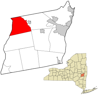
Glen is a town in Montgomery County, New York, United States. The population was 2,507 at the 2010 census. The town was named after Jacob Glen, an early landowner.

Hagaman, formerly Hagamans Mills, is a village in Montgomery County, New York, United States. The population was 1,292 at the 2010 census. It is named after Joseph Hagaman, the founding father.

Nelliston is a village in Montgomery County, New York, United States. The population was 596 at the 2010 census. The name is from members of the Nellis family.

Palatine Bridge is a village in Montgomery County, New York, United States. The population was 737 at the 2010 census. The basis of the name is the community's location in a region settled by Palatine Germans. The Village of Palatine Bridge is in the Town of Palatine. The community is in the western part of the county, west of Amsterdam.

<span class="mw-page-title-main">Conesville, New York</span> Town in New York, United States

Conesville is a town in Schoharie County, New York, United States. The population was 687 at the 2020 census. The town is named after Jonathan Cone, an early resident.

<span class="mw-page-title-main">Gilboa, New York</span> Town in New York, United States

Gilboa is a town in Schoharie County, New York, United States. The population was 1,111 at the 2020 census.

<span class="mw-page-title-main">Jefferson, New York</span> Town in Schoharie County, New York, US

Jefferson is a town in Schoharie County, New York, United States. The population was 1,333 at the 2020 census. The town is on the southwestern border of the county and is east of Oneonta.

<span class="mw-page-title-main">Seward, New York</span> Town in New York, United States

Seward is a town in Schoharie County, New York, United States. The population was 1,583 at the 2020 census. The town is named after senator, governor, and secretary of state William H. Seward.

<span class="mw-page-title-main">Sharon, New York</span> Town in New York, United States

Sharon is a town in Schoharie County, New York, United States. The population was 1,697 at the 2020 census. The town is named after a location in Connecticut, whence some early settlers came. The town of Sharon is in the northwestern corner of the county and is southwest of Amsterdam.

<span class="mw-page-title-main">Summit, New York</span> Town in New York, United States

Summit is a town in Schoharie County, New York, United States. The population was 1,072 at the time of the 2020 census. The name is derived from a peak that was thought to be the highest elevation in the county.

<span class="mw-page-title-main">Wright, New York</span> Town in New York, United States

Wright is a town in Schoharie County, New York, United States. The population was 1,516 at the 2020 census. The town was named after governor Silas Wright.

<span class="mw-page-title-main">Esperance (village), New York</span> Village in New York, United States

Esperance is a village in Schoharie County, New York, United States. The population was 345 at the 2010 census. The village was given the French name for "hope."

<span class="mw-page-title-main">Esperance, New York</span> Town in New York, United States

Esperance is a town in Schoharie County, New York, United States. The population was 1,806 at the 2020 census. The town was given the name of the principal village, which was named for "hope" in French.

Richmondville is a village in Schoharie County, New York, United States. The population was 918 at the 2010 census.

<span class="mw-page-title-main">Schoharie, New York</span> Town in New York, United States

Schoharie is an incorporated town in and the county seat of Schoharie County, New York, United States. The population was 3,107 at the 2020 census.

References

  1. "ArcGIS REST Services Directory". United States Census Bureau. Retrieved September 20, 2022.
  2. "National Register Information System". National Register of Historic Places . National Park Service. March 13, 2009.
  3. "National Register of Historic Places". Weekly List of Actions Taken on Properties: 9/08/14 through 9/12/14. National Park Service. September 19, 2014.
  4. "US Gazetteer files: 2010, 2000, and 1990". United States Census Bureau. February 12, 2011. Retrieved April 23, 2011.
  5. "Census of Population and Housing". Census.gov. Retrieved June 4, 2015.
  6. "U.S. Census website". United States Census Bureau . Retrieved January 31, 2008.