
Schoharie County is a county in the U.S. state of New York. As of the 2020 census, the population was 29,714, making it the state's fifth-least populous county. The county seat is Schoharie. "Schoharie" comes from a Mohawk word meaning "floating driftwood." Schoharie County is part of the Albany-Schenectady-Troy, NY Metropolitan Statistical Area.

Rensselaerville is a town in Albany County, New York, United States. The population was 1,826 at the 2020 census. The town is named after Stephen Van Rensselaer.

Roxbury is a town in Delaware County, New York, United States. The population was 2,247 at the 2020 census. The town is at the eastern end of the county.

Broome is a town in Schoharie County, New York, United States. The population was 947 at the 2000 census. The town is named after John Broome.

Fulton is a town in Schoharie County, New York, United States. The population was 1,495 at the 2000 census. Within the town of Fulton are the hamlets of Breakabeen and Fultonham. The town is in the center of the county and is also one of the larger towns in the county. Fulton is west of Albany.

Gilboa is a town in Schoharie County, New York, United States. The population was 1,111 at the 2020 census.

Livingston Manor is a hamlet in Sullivan County, New York, United States. The population was 1,053 at the 2020 census.
Middleburgh is a village in Schoharie County, New York, United States. The population was 1,500 at the 2010 census. The Village of Middleburgh is in the southwestern part of the Town of Middleburgh and is west of Albany.

Middleburgh is a town in Schoharie County, New York, United States. The population was 3,515 at the 2000 census.
Schoharie is an incorporated town in and the county seat of Schoharie County, New York. The population was 3,299 at the 2000 census.

Schoharie Creek is a river in New York that flows north 93 miles (150 km) from the foot of Indian Head Mountain in the Catskills through the Schoharie Valley to the Mohawk River. It is twice impounded north of Prattsville to create New York City's Schoharie Reservoir and the Blenheim-Gilboa Power Project.

New York State Route 30 (NY 30) is a state highway in the central part of New York in the United States. It extends for 300.71 miles (483.95 km) from an interchange with NY 17 in the Southern Tier to the US–Canada border in the state's North Country, where it continues into Quebec as Route 138. On a regional level, the route serves to connect the Catskill Park to the Adirondack Park. In the latter, NY 30 is known as the Adirondack Trail. Aside from the state parks, the route serves the city of Amsterdam and several villages.
New York State Route 23 (NY 23) is an east–west state highway in the eastern portion of New York in the United States. It extends for 156.15 miles (251.30 km) from an intersection with NY 26 in the Central New York town of Cincinnatus in Cortland County to the Massachusetts state line in the Berkshire Mountains, where it continues east as that state's Route 23. Along the way, it passes through many communities, including the cities of Norwich and Oneonta. Outside of the communities, the route serves largely rural areas of the state and traverses the Catskill Mountains in the state's Central New York Region. NY 23 crosses the Hudson River at Catskill via the Rip Van Winkle Bridge.

New York State Route 145 (NY 145) is a state highway in eastern New York in the United States. The highway extends for 47 miles (76 km) from NY 23 in the Greene County town of Cairo to U.S. Route 20 (US 20) in the Schoharie County town of Sharon. Along the way, NY 145 intersects NY 30 in Middleburgh and Interstate 88 (I-88) east of Cobleskill. NY 145 is a two-lane highway its entire length, with a passing lane on hills leaving Middleburgh in both directions. The route follows parts of the Susquehannah Turnpike from Cairo through East Durham and west.
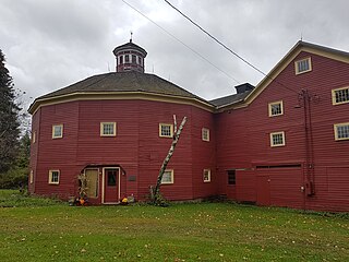
Parker 13-Sided Barn is an officially registered historic barn nestled in the hamlet of Jefferson in Schoharie County, New York. It is located on State Route 10 between Harpersfield and Stamford. The barn has a long and colorful history, built in 1896 and one of only two 13-sided barns listed in the National Register of Historic Places in this area of New York state. It meets the definition of being a round barn.
Fultonham is a hamlet in Fulton, Schoharie County, New York, United States. Fultonham is located within the historic Schoharie Valley.

Breakabeen is a hamlet in the town of Fulton in Schoharie County, New York, United States. This hamlet played a role during the American Revolution and is home to a historic cemetery. Breakabeen is one of the hamlets that are situated in the Schoharie Valley. A number of structures in the hamlet are included in the Breakabeen Historic District, listed on the National Register of Historic Places in 1974.
US Post Office–Middleburgh is a historic post office building located at Middleburgh in Schoharie County, New York, United States. It was designed and built 1939–1940, and is one of a number of post offices in New York State designed by the Office of the Supervising Architect of the Treasury Department under Louis A. Simon. The building is in the Colonial Revival style and is a one-story, five-bay, steel frame structure on a raised concrete foundation. The interior features a 1941 mural by Mary Earley titled "Dance of the Hop Pickers."

The West Kill, an 11-mile-long (18 km) tributary of Schoharie Creek, flows through the town of Lexington, New York, United States, from its source on Hunter Mountain, the second-highest peak of the Catskill Mountains. Ultimately its waters reach the Hudson River via the Mohawk. Since it drains into the Schoharie upstream of Schoharie Reservoir, it is part of the New York City water supply system. It lends its name to both a mountain to its south and a small town midway along its length.

Batavia Kill is a 21-mile-long (34 km) tributary of Schoharie Creek, that flows across the towns of Windham, Ashland and Prattsville in the U.S. state of New York. Its waters reach the Hudson River via Schoharie Creek and the Mohawk River. Since it drains into the Schoharie upstream of Schoharie Reservoir, it is part of the New York City water supply system. From the source to Maplecrest, Batavia Kill drains the northern slopes of the Blackhead Mountains, which include Thomas Cole Mountain, Black Dome, and Blackhead Mountain, the fourth-, third-, and fifth-highest peaks in the Catskills, respectively.

