
Schoharie County is a county in the U.S. state of New York. As of the 2020 census, the population was 29,714, making it the state's fifth-least populous county. The county seat is Schoharie. "Schoharie" comes from a Mohawk word meaning "floating driftwood." Schoharie County is part of the Albany-Schenectady-Troy, NY Metropolitan Statistical Area.

Vinton County is a county located in the U.S. state of Ohio. As of the 2020 census, the population was 12,800, making it the least populous county in the state. Its county seat is McArthur. The county is named for Samuel Finley Vinton, US Representative from Ohio.

Blenheim is a town in the southwestern part of Schoharie County, New York, United States. It is located east of Oneonta. At the 2020 census, the population was 308. The town was named after a land patent, which itself was named after the Battle of Blenheim.

Gilboa is a town in Schoharie County, New York, United States. The population was 1,111 at the 2020 census.

The New York metropolitan area, broadly referred to as the Tri-State area and often also called Greater New York, is the largest metropolitan area in the world by urban landmass, encompassing 4,669.0 sq mi (12,093 km2). The New York metropolitan area is one of the most populous metropolitan areas in the world and the only U.S. metropolitan area larger than twenty million residents as of the 2020 United States census. The vast metropolitan area includes New York City, the nation's most populous city, Long Island, the Mid- and Lower Hudson Valley in New York State; fourteen counties and eleven of the largest cities in New Jersey; and six of the seven largest cities in Connecticut. The phrase "Tri-State area" usually refers to New York / New Jersey / Connecticut, although an increasing number of people who work in New York City commute from Pennsylvania, particularly from the Lehigh Valley, Bucks County, and Poconos regions in eastern Pennsylvania. The New York metropolitan area is the geographic and demographic hub of the larger Northeast megalopolis.

Schoharie Creek is a river in New York that flows north 93 miles (150 km) from the foot of Indian Head Mountain in the Catskills through the Schoharie Valley to the Mohawk River. It is twice impounded north of Prattsville to create New York City's Schoharie Reservoir and the Blenheim-Gilboa Power Project.
The New York Power Authority (NYPA), is the largest state public power utility in the United States providing some of the lowest-cost electricity in the nation, operating 16 generating facilities and more than 1,400 circuit-miles of transmission lines. Its main administrative offices are in White Plains, New York
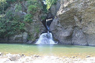
Mine Kill State Park is a 500-acre (2.0 km2) state park located in Schoharie County, New York, United States. The park is in the southeast part of the Town of Blenheim.

The Brown Covered Bridge is a wooden covered bridge in Shrewsbury, Vermont. Located in the northwestern part of the town, it carries Upper Cold River Road over the Cold River. It was closed to vehicular traffic in 2011 due to damage from Hurricane Irene and reopened on July 5, 2016. Built in 1880 by noted Vermont bridgewright Nichols M. Powers, it was designated a National Historic Landmark in 2014, cited as one of the finest and least-altered examples of a Town lattice truss covered bridge in the United States.
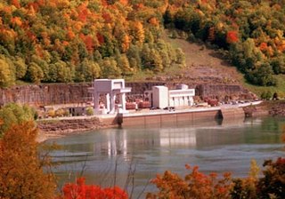
The Blenheim–Gilboa Pumped Storage Power Station is a pumped-storage hydroelectricity plant in the Catskill Mountains of New York State. The plant is part of the New York Power Authority, and can generate over 1,100 megawatts (1,500,000 hp) of electricity, all of which is sent to New York City. It is used daily to cover peak demand. There are two reservoirs that are involved in the project, both with a capacity of 5 billion US gallons (19,000,000 m3); one at the foot of Brown Mountain in the Schoharie Valley, and another one at the top of the mountain. The power station has an accumulated capacity of about 12,000 megawatt-hours (43,000 GJ) after storing up to 17,000 megawatt-hours (61,000 GJ).

Glenville is a neighborhood and census-designated place in the town of Greenwich in Fairfield County, Connecticut, United States. As of the 2010 census, it had a population of 2,327. It is located in the western part of Greenwich at the falls of the Byram River, which provided waterpower when this was a mill village. The area is home to Glenville Elementary school, Western Civic Center and a volunteer fire station, the Glenville Fire Department.

Gilboa Fossil Forest, New York, United States, is a petrified forest and one of the oldest known forests. Located near the Gilboa Dam in Schoharie County, New York, the region is home to tree trunks from the Devonian period. The fossils, some of the only survivors of their type in the world, are believed to have been from one of the first forests on Earth, and was part of the Earth's afforestation. Paleobotanists have been interested in the site since the 1920s when construction work for a water supply project found several large, vertical fossilized stumps. Some of these remain on display at the Gilboa Dam site and the New York Power Authority Blenheim-Gilboa Visitor's Center in Schoharie County and at the New York State Museum.
East Durham is a hamlet within the town of Durham, which is located in the U.S. state of New York, approximately 535 feet (163 m) above sea level, in Greene County. It has the ZIP Code 12423 and the area code 518. It is an Irish town where many Irish immigrants and vacationers visit often.

National Harbor is a census-designated place (CDP) in Prince George's County, Maryland, United States, located along the Potomac River near the Woodrow Wilson Bridge and just south of Washington, D.C. It originated as a 300-acre (1.2 km2) multi-use waterfront development. Per the 2020 census, the population was 5,509.

Old Blenheim Bridge was a wooden covered bridge that spanned Schoharie Creek in North Blenheim, New York, United States. With an open span of 210 feet (64 m), it had the second longest span of any surviving single-span covered bridge in the world. The 1862 Bridgeport Covered Bridge in Nevada County, California, currently undergoing repairs due to 1986 flooding is longer overall at 233 feet (71 m) but is argued to have a 208 feet (63 m) clear span. The bridge, opened in 1855, was also one of the oldest of its type in the United States. It was destroyed by flooding resulting from Tropical Storm Irene in 2011. Rebuilding of the bridge commenced in 2017 and was completed in 2018.

The Bridgeport Covered Bridge is located in Bridgeport, Nevada County, California, southwest of French Corral and north of Lake Wildwood. It is used as a pedestrian crossing over the South Yuba River. The bridge was built in 1862 by David John Wood. Its lumber came from Plum Valley in Sierra County, California. The bridge was closed to vehicular traffic in 1972 and pedestrian traffic in 2011 due to deferred maintenance and "structural problems".
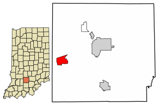
Williams is an unincorporated community and census-designated place in Spice Valley Township, Lawrence County, Indiana, United States. As of the 2010 census, the population was 286.
The Lansing Manor House is a historic home located in North Blenheim, Schoharie County, New York, United States, adjacent to the Blenheim-Gilboa Visitors Center and Mine Kill State Park. It was built in 1819 by John Lansing Jr. for his daughter and son-in-law, Jacob Livingston Sutherland. John Lansing Jr. represented New York as a delegate to the Constitutional Convention in 1787, and the state's Ratification Convention in 1788.

Cousins Island is an island in Casco Bay within the town of Yarmouth in Cumberland County, Maine, United States. It is listed as a census-designated place, with a population of 490 as of the 2010 census. The CDP is part of the Portland–South Portland–Biddeford, Maine Metropolitan Statistical Area.

