Waterloo (village), New York

Last updated

Waterloo
United States Post Office Waterloo, New York front view 2013.jpg
Nickname: 
waterloo
USA New York location map.svg
Red pog.svg
Waterloo
Location within the state of New York
Coordinates: 42°54′13″N76°51′34″W / 42.90361°N 76.85944°W / 42.90361; -76.85944
Country United States
State New York
County Seneca
Town(s) Waterloo and Fayette
IncorporatedApril 9, 1824;199 years ago (1824-04-09) [1]
Government
  Type Board of Trustees
   Mayor Jack O'Connor [2]
   Clerk Don Northrup
   Court Justice Conrad A. Struzik
Area
[3]
  Total2.20 sq mi (5.71 km2)
  Land2.16 sq mi (5.59 km2)
  Water0.05 sq mi (0.12 km2)
Elevation
453 ft (138 m)
Population
 (2020)
  Total4,810
  Density2,229.95/sq mi (860.99/km2)
Time zone UTC-5 (Eastern (EST))
  Summer (DST) UTC-4 (EDT)
ZIP code
13165
Area code(s) 315 and 680
FIPS code 36-78553 [4]
GNIS feature ID0968900 [5]
Website http://www.waterloony.com/

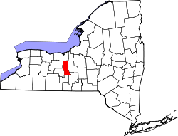
Waterloo is a village and primary county seat of Seneca County, New York, United States. [6] The population was 5,171 at the 2010 census and is now the most populated village in Seneca County. The village is named after Waterloo, Belgium, where Napoleon was defeated.[ citation needed ] It is the primary county seat of Seneca County, with the other being Ovid as part of a two-shire system established in 1822. [7] [8] Most of the county administrative offices are located in the village. [9] Therefore, many political sources only list Waterloo as the county seat.

Contents

The Village of Waterloo is mostly in the Town of Waterloo, but the part south of the Cayuga-Seneca Canal of the village is in the Town of Fayette and a small area in the southeast of the village is in Town of Seneca Falls. Waterloo is east of Geneva and is located in between the two main Finger Lakes, Seneca Lake and Cayuga Lake.

History

The area was within the realm of the Cayuga nation, one of several bands to form the Iroquois League. The current site of the village was the location of the former Cayuga village "Skoiyase" (or Skoi-Yase), meaning "flowing water", which was established around 1500. [10] They were visited by Jesuit missionaries in the 17th century. After the Sullivan Expedition of 1779 destroyed Skoiyase, many natives left the area. The land then became part of the Central New York Military Tract, reserved for veterans.

The first new settler, Jabez Gorham, arrived on the site of the village around 1795. The early village was known as "New Hudson". It was also known as "Scoys", based on the name of the former Indian village. [11]

Because the original county seat in Ovid was deemed too close to the south county line after land was lost from Seneca County, Waterloo became the county seat in 1819. A similar fate befell Waterloo, when much of the north of Seneca County was lost, leaving the village close to the northern county line. The outcome was that both villages were made joint county seats, even though some of the lost towns were later returned to the county. Seneca County remains a two-shire county, although nearly all government activity now occurs in Waterloo. [6] In honor of the two-shire history, the County Board of Supervisors will at least once a year hold a meeting in Ovid at the buildings locally called the "Three Bears".

Planning for the Women's Rights Convention in 1848 in Seneca Falls took place in Waterloo. [12]

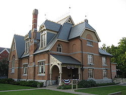
The Village of Waterloo was incorporated in 1824 and again in 1866, the same year it celebrated the first Memorial Day. Waterloo was officially designated as the birthplace of Memorial Day in 1966 by President Lyndon B. Johnson. [13] The Memorial Day Museum is in the village. However, in 2014, Bellware and Gardiner challenged this designation in The Genesis of the Memorial Day Holiday in America. They uncovered evidence that the origin story is a hoax including information ignored by the Centennial Committee backing the proclamation. This includes a report in a New York newspaper that predates by several years any of the sources used by the committee. It describes, in detail, Waterloo's first Memorial Day and places it in 1868. They also note other inconsistencies between the historical record and the story compiled by the Centennial Committee and the lack of discussion or debate in Congress prior to the resolution recognizing Waterloo as the birthplace of the holiday. [14]

Geography

Waterloo is located at 42°54′13″N76°51′34″W / 42.90361°N 76.85944°W / 42.90361; -76.85944 (42.903697, -76.859517). [15]

According to the United States Census Bureau, the village has a total area of 2.2 square miles (5.6 km2), of which, 2.1 square miles (5.4 km2) of it is land and 0.1 square miles (0.2 km2) of it (3.24%) is water.

The Seneca River/Cayuga-Seneca Canal pass through the village, linking the area to the Erie Canal system.

US Route 20, conjoined with New York State Route 5, intersects New York State Route 96 in the village.

The largest active landfill in New York State, Seneca Meadows, is northeast of Waterloo in the town of Seneca Falls.

National Register of Historic Places listings in Waterloo

Landmark nameImageDate listedLocationSummary
William H. Burton House Burton House Waterloo Aug 09.jpg June 14, 199635 E. Main St.
42°54′16″N76°51′41″W / 42.90444°N 76.86139°W / 42.90444; -76.86139 (Burton, William H., House)
First Presbyterian Church First Presbyterian Church Waterloo Aug 09.jpg November 29, 1996E. Main St., E of jct. with NY 96
42°54′14″N76°51′39″W / 42.90389°N 76.86083°W / 42.90389; -76.86083 (First Presbyterian Church)
Hunt House JANE HUNT HOUSE.jpg August 29, 1980401 E. Main St.
42°54′22″N76°50′40″W / 42.90611°N 76.84444°W / 42.90611; -76.84444 (Hunt House)
Historic home, c. 1830.
M'Clintock House HUNT HOUSE.jpg August 29, 198014 E. Williams
42°54′19″N76°51′42″W / 42.90528°N 76.86167°W / 42.90528; -76.86167 (M'Clintock House)
Historic home, important to the first Women's Rights Convention.
Saint Paul's Church St Pauls Church Waterloo Aug 09.jpg March 9, 1997101 E. Williams St.
42°54′20″N76°51′35″W / 42.90556°N 76.85972°W / 42.90556; -76.85972 (Saint Paul's Church)
United Methodist Church United Methodist Church Waterloo Aug 09.jpg September 24, 200421 E. Williams St.
42°54′28″N76°51′40″W / 42.90778°N 76.86111°W / 42.90778; -76.86111 (United Methodist Church)
U.S. Post Office May 11, 19892 E. Main St.
42°54′15″N76°51′46″W / 42.90417°N 76.86278°W / 42.90417; -76.86278 (US Post Office--Waterloo)
Waterloo Library Waterloo Library Aug 09.jpg June 14, 199631 E. Williams St.
42°54′20″N76°51′40″W / 42.90556°N 76.86111°W / 42.90556; -76.86111 (Waterloo Library)
James Russell Webster House December 11, 2007115 E. Main St.
42°54′23″N76°51′33″W / 42.90639°N 76.85917°W / 42.90639; -76.85917 (James Russell Webster House)
Historic home, c. 1850–1855.

Demographics

Historical population
CensusPop.Note
1860 3,375
1870 4,08621.1%
1880 3,893−4.7%
1890 4,35011.7%
1900 4,256−2.2%
1910 3,931−7.6%
1920 3,809−3.1%
1930 4,0476.2%
1940 4,010−0.9%
1950 4,43810.7%
1960 5,09814.9%
1970 5,4186.3%
1980 5,303−2.1%
1990 5,116−3.5%
2000 5,111−0.1%
2010 5,1711.2%
2020 4,810−7.0%
U.S. Decennial Census [16]

As of the census [4] of 2010, there were 5,171 people, 2,039 households, and 1,323 families residing in the village. The population density was 2,462.4 inhabitants per square mile (950.7/km2). The racial makeup of the village was 96.6% White, 1.1% Black or African American, 0.0% Native American, 0.4% Asian, 0.0% Pacific Islander, 0.2% from other races, and 1.6% from two or more races. Hispanic or Latino of any race were 2.2% of the population.

There were 2,039 households, out of which 28.0% had children under the age of 18 living with them, 43.8% were married couples living together, 14.9% had a female householder with no husband present, and 35.1% were non-families. 29.1% of all households were made up of individuals, and 12.8% had someone living alone who was 65 years of age or older. The average household size was 2.39 and the average family size was 2.88.

In the village, the population was spread out, with 24.5% under the age of 20, 6.1% from 20 to 24, 22.8% from 25 to 44, 26.3% from 45 to 64, and 20.4% who were 65 years of age or older. The median age was 42.3 years. For every 100 females, there were 86.5 males. For every 100 females age 18 and over, there were 84.2 males.

The median income for a household in the village was $48,214, and the median income for a family was $65,709. Males had a median income of $43,393 versus $27,328 for females. The per capita income for the village was $23,777. About 5.5% of families and 10.6% of the population were below the poverty line, including 11.3% of those under age 18 and 5.9% of those age 65 or over.

Housing

There were 2,164 housing units at an average density of 1,030.5 per square mile (397.9/km2). 5.8% of housing units were vacant.

There were 2,039 occupied housing units in the village. 1,424 were owner-occupied units (69.8%), while 615 were renter-occupied (30.2%). The homeowner vacancy rate was 1.4% of total units. The rental unit vacancy rate was 7.5%. [4]

Notable people

Related Research Articles

<span class="mw-page-title-main">Cayuga County, New York</span> County in New York, United States

Cayuga County is a county in the U.S. state of New York. As of the 2020 census, the population was 76,248. Its county seat and largest city is Auburn. The county was named for the Cayuga people, one of the Native American tribes in the Iroquois Confederation.

<span class="mw-page-title-main">Seneca County, New York</span> County in New York, United States

Seneca County is located in the U.S. state of New York. As of the 2020 census, the population was 33,814. The primary county seat is Waterloo, moved there from the original county seat of Ovid in 1819. It became a two-shire county in 1822, which currently remains in effect and uses both locations as county seats although the majority of Seneca County administrative offices are located in Waterloo. Therefore, most political sources list only Waterloo as the county seat. The county's name comes from the Seneca Nation of the Haudenosaunee (Iroquois), who occupied part of the region.

<span class="mw-page-title-main">Schuyler County, New York</span> County in New York, United States

Schuyler County is a county in the U.S. state of New York. As of the 2020 census, the population was 17,898, making it the second-least populous county in New York. The county seat is the village of Watkins Glen. The name is in honor of General Philip Schuyler, one of the four major generals in the Continental Army in the American Revolutionary War.

<span class="mw-page-title-main">Aurelius, New York</span> Town in New York, United States

Aurelius is a town in Cayuga County, New York, United States. The population was 2,610 at the 2020 census. The town was named after the Roman emperor Marcus Aurelius. It is at the western edge of the county and borders the city of Auburn.

<span class="mw-page-title-main">Conquest, New York</span> Town in New York, United States

Conquest is a town in Cayuga County, New York, United States. The population was 1,796 at the 2020 census. The name was chosen to mark the victory of those who wished to form the town. Conquest is on the western border of Cayuga County and is west of Syracuse.

<span class="mw-page-title-main">Montezuma, New York</span> Town in New York, United States

Montezuma is a town in Cayuga County, New York, United States. The population was 1,277 at the 2010 census.

<span class="mw-page-title-main">Owasco, New York</span> Town in New York, United States

Owasco is a town in Cayuga County, New York, United States. It is part of the traditional territory of the Cayuga nation. The population was 3,793 at the 2010 census. Owasco is in the eastern part of Cayuga County and is at the southeast city line of Auburn. The town borders Owasco Lake, from where it gets its name.

<span class="mw-page-title-main">Springport, New York</span> Town in New York, United States

Springport is a town in Cayuga County, New York, United States. The population was 2,367 at the 2010 census. The name is derived from the local springs and lakeports. Springport is on the western border of the county and is southwest of Auburn.

Hector is a town in the northeastern corner of Schuyler County, New York, United States. The population was 4,916 at the 2020 census. The town is named after Hector Ely, who at the time was the firstborn son of the town founders. Hector is west of Ithaca.

Covert is a town in Seneca County, New York, United States. The population was 2,135 at the 2020 census.

Fayette is a town in Seneca County, New York, United States. The population was 3,617 at the 2020 census. The town is in the north-central part of the county and is southeast of Geneva, New York.

Romulus is a town in Seneca County, New York, United States. The population was 3,203 at the 2020 census. The town is named after the mythical founder of Rome, Romulus, a name assigned by a clerk with an interest in the classics. It is located in the central part of the county, northwest of Ithaca, New York.

<span class="mw-page-title-main">Tyre, New York</span> Town in New York, United States

Tyre is a town in Seneca County, New York, United States. The population was 1,002 at the 2020 census. The town is named after the Lebanese city of Tyre.

Varick is a town in Seneca County, New York, United States. The population was 1,656 at the 2020 census. The town is named after Richard Varick, an officer in the American Revolution, mayor of New York City, and uncle of the first Town Supervisor, Anthony Dey.

<span class="mw-page-title-main">Trumansburg, New York</span> Village in New York, United States

Trumansburg is a village in Tompkins County, New York, United States. The population was 1,797 at the 2010 census. The name incorporates a misspelling of the surname of the founder, Abner Treman. The Tremans spelled their surname several different ways; "Truman," however, was not one of them. The village's application for a post office established the present spelling. The Village of Trumansburg is located within the Town of Ulysses and is northwest of Ithaca, New York.

Ovid is a village in Seneca County, New York, United States. The population was 602 at the 2010 census. The town was named by a clerk interested in the classics.

Ovid is a town in Seneca County, New York, United States. The population was 2,847 at the 2020 census. The town is named after the Roman poet Ovid, a name assigned by a clerk interested in the classics.

<span class="mw-page-title-main">Seneca Falls (CDP), New York</span> Hamlet and CDP in New York, United States

Seneca Falls is a hamlet and census-designated place in Seneca County, New York, United States. The population was 6,681 at the 2010 census. The 2020 census population of Seneca Falls CDP was 6,809. The hamlet is in the Town of Seneca Falls, east of Geneva. It was an incorporated village from 1831 to 2011.

<span class="mw-page-title-main">Seneca Falls, New York</span> Town in New York, United States

Seneca Falls is a town in Seneca County, New York, United States. The population was 9,027 at the 2020 census.

<span class="mw-page-title-main">Waterloo, New York</span> Town in New York, United States

Waterloo is a town in Seneca County, New York, United States. The population was 7,378 at the 2020 census. The town and its major community are named after Waterloo, Belgium, where Napoleon was defeated.

References

  1. Laws of the State of New York, E Croswell, 1835, W.M. & A. Gould & Co. Albany, page 46, Retrieved Jun. 2, 2015.
  2. Village of Waterloo, Village Government, Retrieved May 25, 2019.
  3. "ArcGIS REST Services Directory". United States Census Bureau. Retrieved September 20, 2022.
  4. 1 2 3 "U.S. Census website". United States Census Bureau . Retrieved May 30, 2015.
  5. "US Board on Geographic Names". United States Geological Survey. October 25, 2007. Retrieved January 31, 2008.
  6. 1 2 "Find a County". National Association of Counties. Retrieved June 7, 2011.
  7. Seneca County, New York – The County Seat Story Archived 2015-05-28 at the Wayback Machine , Retrieved May 27, 2015.
  8. Office of the Seneca County Historian, Written History of Seneca County, New York – Unit Three: Establishment of Seneca County & Townships, Chapter 3: History of the Towns of Seneca County Archived 2015-05-28 at the Wayback Machine , Retrieved May 27, 2015.
  9. Seneca County, New York Departments, Retrieved May 27, 2015.
  10. "History of Waterloo". Waterloo, New York: Birthplace of Memorial Day.
  11. Turner O (1849). Pioneer History of the Holland Purchase of Western New York. p. 362.
  12. "Women's Suffrage in New York State – How New York's Pioneer Feminists Fought for Women's Rights". nyassembly.gov. Retrieved October 16, 2020.
  13. "Lyndon B. Johnson: "Proclamation 3727 – Prayer for Peace, Memorial Day, 1966," May 26, 1966. Online by Gerhard Peters and John T. Woolley, The American Presidency Project". The American Presidency Project.
  14. Bellware, Daniel; Richard Gardiner (2014). The Genesis of the Memorial Day Holiday in America. Columbus State University. pp. 134–143. ISBN   978-0-692-29225-9.
  15. "US Gazetteer files: 2010, 2000, and 1990". United States Census Bureau. February 12, 2011. Retrieved April 23, 2011.
  16. "Census of Population and Housing". Census.gov. Retrieved June 4, 2015.
  17. "Tom Coughlin Record, Statistics, and Category Ranks". Pro-Football-Reference.com. August 31, 1946. Retrieved February 10, 2014.
  18. Roth, Lee (January 14, 2013). "Kevin Sylvester ready to go after lockout". Rochester Democrat and Chronicle . Gannett . Retrieved January 22, 2013.