Lodi (village), New York

Last updated
Lodi, New York
USA New York location map.svg
Red pog.svg
Lodi, New York
Location within the state of New York
Coordinates: 42°36′48″N76°49′27″W / 42.61333°N 76.82417°W / 42.61333; -76.82417 Coordinates: 42°36′48″N76°49′27″W / 42.61333°N 76.82417°W / 42.61333; -76.82417
Country United States
State New York
County Seneca
Town Lodi
IncorporatedNovember 14, 1925 [1]
Government
  Type Board of Trustees
   Mayor Michael Huff
   Clerk Nancy Jones
Area
[2]
  Total0.55 sq mi (1.43 km2)
  Land0.55 sq mi (1.43 km2)
  Water0.00 sq mi (0.01 km2)
Elevation
1,106 ft (337 m)
Population
 (2020)
  Total254
  Density460.98/sq mi (177.94/km2)
Time zone UTC-5 (Eastern (EST))
  Summer (DST) UTC-4 (EDT)
ZIP code
14860
Area code 607
FIPS code 36-43214
GNIS feature ID0974039
Website http://lodiny.com/village/

Lodi is a village in Seneca County, New York, United States. The population was 291 at the 2010 census.

Contents

The Village of Lodi is in the north part of the Town of Lodi and is northwest of Ithaca, New York. It owes its name to the Italian city of Lodi.

Lodi Point State Park is west of the village on the shore of Seneca Lake.

History

This part of New York was in the territory of the Seneca tribe until the Sullivan Expedition drove them away. The area was then assigned to the Central New York Military Tract used to pay soldiers for service in the American Revolution. The Lodi Methodist Church, designed by noted church architect Warren H. Hayes (1847–1899), was listed on the National Register of Historic Places in 1982. [3]

Geography

Lodi is located at 42°36′48″N76°49′27″W / 42.613366°N 76.824082°W / 42.613366; -76.824082 (42.613366, -76.824082). [4]

According to the United States Census Bureau, the village has a total area of 0.6 square miles (1.5 km2).None of the area is covered with water.

Lodi is in the Finger Lakes District of New York.

New York State Route 96A and New York State Route 414 intersect at the village.

Demographics

Historical population
CensusPop.
1880 433
1930 322
1940 36613.7%
1950 362−1.1%
1960 3969.4%
1970 353−10.9%
1980 334−5.4%
1990 3649.0%
2000 338−7.1%
2010 291−13.9%
2020 254−12.7%
U.S. Decennial Census [5]

As of the census [6] of 2010, there were 291 people, 118 households, and 81 families residing in the village. The population density was 485.0 people per square mile (194.0/km2). The racial makeup of the village was 97.6% White, 0.0% Black or African American, 0.7% Native American, 1.0% Asian, 0.0% Pacific Islander, 0.3% from other races, and 0.3% from two or more races. Hispanic or Latino of any race were 1.4% of the population.

There were 118 households, out of which 27.1% had children under the age of 18 living with them, 45.8% were married couples living together, 14.4% had a female householder with no husband present, and 31.4% were non-families. 27.1% of all households were made up of individuals, and 7.6% had someone living alone who was 65 years of age or older. The average household size was 2.47 and the average family size was 2.90.

In the village, the population was spread out, with 27.8% under the age of 20, 5.8% from 20 to 24, 24.4% from 25 to 44, 28.8% from 45 to 64, and 13.1% who were 65 years of age or older. The median age was 40.3 years. For every 100 females, there were 122.1 males. For every 100 females age 18 and over, there were 116.7 males.

The median income for a household in the village was $40,417, and the median income for a family was $52,500. Males had a median income of $31,250 versus $25,000 for females. The per capita income for the village was $19,108. About 21.2% of families and 19.5% of the population were below the poverty line, including 7.3% of those under age 18 and 22.9% of those age 65 or over.

Housing

There were 142 housing units at an average density of 236.7 per square mile (94.7/km2). 16.9% of housing units were vacant.

There were 118 occupied housing units in the village. 97 were owner-occupied units (82.2%), while 21 were renter-occupied (17.8%). The homeowner vacancy rate was 4.0% of total units. The rental unit vacancy rate was 0.0%. [6]

Related Research Articles

<span class="mw-page-title-main">Seneca County, New York</span> County in New York, United States

Seneca County is located in the U.S. state of New York. As of the 2020 census, the population was 33,814. The county seat is Waterloo. It became a one county in 1822, which currently remains in effect and uses one locations as county seats although the majority of Seneca County administrative offices are located in Waterloo. Therefore, most political sources list only Waterloo as the county seat. The county's name comes from the Seneca Nation of the Haudenosaunee (Iroquois), who occupied part of the region.

<span class="mw-page-title-main">Conquest, New York</span> Town in New York, United States

Conquest is a town in Cayuga County, New York, United States. The population was 1,819 at the 2010 census. The name was chosen to mark the victory of those who wished to form the town. Conquest is on the western border of Cayuga County and is west of Syracuse.

Millport is a village in Chemung County, New York, United States. The population was 312 at the 2010 census. The name comes from its former status as a canal port.

<span class="mw-page-title-main">Seneca Knolls, New York</span> Census-designated place in New York, United States

Seneca Knolls is a hamlet in Onondaga County, New York, United States. The population was 2,011 at the 2010 census.

Burdett is a village in Schuyler County, New York, United States. The population was 357 at the 2000 census.

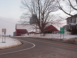
Covert is a town in Seneca County, New York, United States. The population was 2,154 at the 2010 census.

Interlaken is a village in Seneca County, New York, United States. The population was 602 at the 2010 census. The name is related to the village's position between two lakes.

Romulus is a town in Seneca County, New York, United States. The population was 4,316 at the 2010 census. The town is named after the mythical founder of Rome, Romulus, a name assigned by a clerk with an interest in the classics. It is located in the central part of the county, northwest of Ithaca, New York.

<span class="mw-page-title-main">Tyre, New York</span> Town in New York, United States

Tyre is a town in Seneca County, New York, United States. The population was 981 at the 2010 census. The town is named after the Lebanese city of Tyre.

<span class="mw-page-title-main">Clyde, New York</span> Village in New York, United States

Clyde is a village in Wayne County, New York, United States. The population was 2,093 at the 2010 census. It was named after the River Clyde, in Scotland, and the village sits on the Clyde River, a tributary of the Seneca River.

<span class="mw-page-title-main">Huron, New York</span> Town in New York, United States

Huron is a town in Wayne County, New York, United States. The population was 2,118 at the 2010 census. The town is named after the Huron Indians.

<span class="mw-page-title-main">Dresden, Yates County, New York</span> Village in New York, United States

Dresden is a village in Yates County, New York, United States. The population was 308 at the 2010 census. The village was named after Dresden in Germany.

<span class="mw-page-title-main">Dundee, New York</span> Village in New York, United States

Dundee is a village in Yates County, New York, United States. The population was 1,725 at the 2010 census. The name was taken from Dundee, the city in Scotland with a population of 148,260.

Lodi is a town in Seneca County, New York, United States. The population was 1,550 at the 2010 census.

Ovid is a village in Seneca County, New York, United States. The population was 602 at the 2010 census. The town was named by a clerk interested in the classics.

Ovid is a town in Seneca County, New York, United States. The population was 2,311 at the 2010 census. The town is named after the Roman poet Ovid, a name assigned by a clerk interested in the classics.

<span class="mw-page-title-main">Seneca Falls (CDP), New York</span> Hamlet and CDP in New York, United States

Seneca Falls is a hamlet and census-designated place in Seneca County, New York, United States. The population was 6,681 at the 2010 census. The hamlet is in the Town of Seneca Falls, east of Geneva. It was an incorporated village from 1831 to 2011.

<span class="mw-page-title-main">Waterloo (village), New York</span> Village in New York, United States

Waterloo is a village and primary county seat of Seneca County, New York, United States. The population was 5,171 at the 2010 census and is now the most populated village in Seneca County. The village is named after Waterloo, Belgium, where Napoleon was defeated. It is the primary county seat of Seneca County, with the other being Ovid as part of a two-shire system established in 1822. Most of the county administrative offices are located in the village. Therefore, many political sources only list Waterloo as the county seat.

<span class="mw-page-title-main">Waterloo (town), New York</span> Town in New York, United States

Waterloo is a town in Seneca County, New York, United States. The population was 7,642 at the 2010 census. The town and its major community are named after Waterloo, Belgium, where Napoleon was defeated.

Romulus is a hamlet located in the Town of Romulus, Seneca County, New York, United States on the border with the Town of Varick. The population was 409 at the 2010 census.

References

  1. The Interlaken Review, November 20, 1925, page 3, Retrieved Jun. 2, 2015
  2. "ArcGIS REST Services Directory". United States Census Bureau. Retrieved September 20, 2022.
  3. "National Register Information System". National Register of Historic Places . National Park Service. March 13, 2009.
  4. "US Gazetteer files: 2010, 2000, and 1990". United States Census Bureau. 2011-02-12. Retrieved 2011-04-23.
  5. "Census of Population and Housing". Census.gov. Retrieved June 4, 2015.
  6. 1 2 "U.S. Census website". United States Census Bureau . Retrieved 2015-05-27.