Seneca Lake is a Finger Lake in central New York state. Spanning four counties - Schuyler, Seneca, Yates, and Ontario - it is the largest of the eleven lake glacial chain, and the deepest glacial lake entirely within the state.[citation needed]
Seneca Lake is 38 miles (61km) long, has a surface area of 66.9 square miles (173km2), a maximum depth of over 618 feet (188m), and holds the most water of all the Finger Lakes (estimated at 3.81 cubic miles (15.9km3), roughly half that of the entire chain).[1]
Seneca is celebrated as the lake trout capital of the world and hosts the National Lake Trout Derby. Its significant depth and accessibility enable the US Navy to conduct testing and evaluation of range on equipment such as sonar. [2]
At 38 miles (61km) long, it is the second longest of the Finger Lakes and has the largest volume, estimated at 3.81 cubic miles (15.9km3), roughly half of the water in all the Finger Lakes. It has an average depth of 291 feet (89m),[3] a maximum depth of 618 feet (188m), and a surface area of 66.9 square miles (173km2).
For comparison, Scotland's famous Loch Ness is 22.5 miles (36.2km) long, 1.7 miles (2.7km) wide, has a surface area of 21.8 square miles (56km2), an average depth of 433 feet (132m), a maximum depth of 744.6 feet (227.0m), and total volume of 1.8 cubic miles (7.5km3) of water.
It is fed by underground springs and replenished at a rate of 328,000USgal (1,240m3) per minute. These springs keep the water moving in a circular motion, giving it little chance to freeze over. Because of Seneca Lake's great depth temperature near the bottom remains remain a near-constant 39°F (4°C).[4]
Ecology
Seneca lake has a typical aquatic population for large deep lakes in the northeast, with coldwater fish such as lake trout and Landlocked Atlantic salmon inhabiting the deeper waters, and warmwater fish such as smallmouth bass and yellow perch inhabiting shallower areas. The lake is also home to a robust population of "sawbellies," the local term for alewife shad.
Seneca Lake was formed at least two million years ago by glacial carving of streams and valleys. Originally it was a part of a series of rivers that flowed northward. Around this time many continental glaciers moved into the area and started the Pleistocene glaciation also known as the Ice Age. It is presumed that the Finger Lakes were created by many advances and retreats of massive glaciers that were up to 2 miles (3km) thick.[5]
After the war, the Iroquois were forced to cede their land when Britain was defeated. Their millions of acres were sold and some lands in this area were granted to veterans of the army in payment for their military service. A slow stream of European-American settlers began to arrive circa 1790. Initially the settlers were without a market nearby or a way to get their crops to market. The settlers' isolation ended in 1825 with the opening of the Erie Canal.
The canal linked the Finger Lakes Region to the outside world. Steamships, barges and ferries quickly plied the lake. The earlier, short Crooked Lake Canal linked Seneca Lake to Keuka Lake.
Numerous canal barges sank during operations and rest on the bottom of the lake. A collection of barges at the southwest end of the lake, near the village of Watkins Glen, are being preserved and made accessible for scuba diving by the Finger Lakes Underwater Preserve Association.
In July 1900, newspaper reports[7] carried reports that on the evening of 14 July 1899, the steamboat Otetiani, carrying several dozen passengers, encountered a 25-foot-long[7] sea monster with "two rows of sharp, white teeth." The steamer is said to have given chase to the creature and deliberately rammed it at full speed. The creature was struck by the ship's paddle wheel midway between head and tail, it spine broken. It raised its four-foot-long head, then gave a gasp as it died. The ship attempted to rope the monster and tow it back to shore, but it sank to the bottom of Seneca Lake.[8][9] A report sometime later in the Geneva Gazette suggested that the incident was a hoax.[9]
Painted rocks
Highly visible painted rocks located at the southern end of the lake on the eastern cliff face depicting an American flag, teepee, and several Native Americans painted in 1929 during the Sullivan Sesquicentennial, celebrating the 150th anniversary of the Sullivan Expedition that drove Native Americans off their land. They contain the errors that peoples in the Seneca Region used longhouses and not tee-pees,[10] and is unfurled to the left, which is never portrayed that way for exhibition.[11]
Some older paintings located on the bottom of the cliff were done somewhat earlier, for tourists on Seneca Lake boat tours,[12] who were given the mythology that they had been done in 1779 after the Senecas escaped from the Sullivan Campaign. Historian Barbara Bell, has cleared this up in her 2005 book.
Seneca Guns
Seneca Lake is also the site of strange and currently unexplained cannon-like booms and shakes that are heard and felt in the surrounding area.[13] They are known locally as the Seneca Guns, Lake Drums, or Lake Guns, and these types of phenomena are known elsewhere as skyquakes. The term lake guns originated in the short story "The Lake Gun" by James Fenimore Cooper in 1851.[14] While there is no explanation that takes into account sounds the Iroquois heard before Cooper's time, it is possible sonic booms have been mistaken for natural sounds in modern days.[15]
Sampson Navy and Air Force bases
The east side of Seneca Lake was once home to Sampson Naval Base, a military training ground primarily used during World War II. It became Sampson Air Force Base during the Korean War and was used for basic training. After Sampson AFB closed, the airfield remained as Seneca Army Airfield until closed in 2000.[16] The training grounds of Sampson have since been converted to a civilian picnic area called Sampson State Park.[17]
The Naval Undersea Warfare Center (NUWC) Sonar test facility is a US Navy facility on the west side of the lake. A scale model of the sonar section of the nuclear submarine USS Seawolf (SSN 21) was tested during the ship's development,[18] leading to its launch in June 1995.
Water quality
There is a YSI EMM-2500 Buoy Platform located in the north end of Seneca Lake roughly in the center. Its coordinates are: latitude: 42°41'49.99"N, longitude: 76°55'29.93"W. The buoy has cellular modem communications and measures wind speed and direction, relative humidity, air temperature, barometric pressure, light intensity, and the water's depth and temperature, conductivity, turbidity, and chlorophyll-a levels.[19]
The buoy was initially deployed in June 2006. The water depth where it is located is about 200 feet (60m).[20]
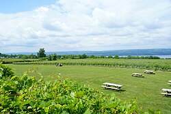
Viticulture and winemaking in the area date back to the 1866 foundation of the Seneca Lake Wine Company, the first major local winery. Modern wine production began in the 1970s with the establishment of several wineries and the passage of the New York Farm Winery Act of 1976.[23] The region was established as an American Viticultural Area in 1988.[24]
The Seneca Lake Wine Trail hosts many events on and around the lake, including the annual winter 'Deck the Halls' event showcasing local wineries' vintages.
↑"Cayuga Lake wins own wine region". The Ithaca Journal. Ancestry.com#Newspapers.com. 6 May 1988. The new Cayuga Lake wine region was established inside the existing Fingers Lake wine region and includes parts of Seneca, Tompkins, and Cayuga counties located adjacent to Cayuga Lake between Seneca and Owasco Lakes.
This page is based on this Wikipedia article Text is available under the CC BY-SA 4.0 license; additional terms may apply. Images, videos and audio are available under their respective licenses.