Rochester metropolitan area | ||
|---|---|---|
| Rochester, MN Metropolitan Statistical Area | ||
 Rochester, Minnesota skyline | ||
 Interactive map of Rochester, MN MSA
| ||
| Coordinates: 43°57′22″N92°20′17″W / 43.95611°N 92.33806°W | ||
| Country | | |
| State | | |
| Largest city | Rochester | |
| Other cities | Byron, Kasson, Lake City, Stewartville | |
| Area | ||
• Total | 2,477 sq mi (6,420 km2) | |
| Lowest elevation | 1,211 ft (369 m) | |
| Population (2020) | ||
• Total | 226,329 (Metro) 316,029 (Combined) | |
| 230,742 (Metro) 321,615 (Combined) | ||
| • Rank | Metro: 207th in the U.S. Combined: 113rd in the U.S. | |
| • Density | 91.37/sq mi (35.28/km2) | |
| GDP | ||
| • Total | $17.949 billion (2023) | |
| Time zone | UTC–6 (Central (CST)) | |
| • Summer (DST) | UTC–5 (CDT) | |
| Area codes | 507 and 924 | |
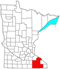
The Rochester metropolitan statistical area, as defined by the United States Census Bureau, is a metropolitan statistical area consisting of four counties in southeast Minnesota, Dodge, Fillmore, Olmsted, and Wabasha. The principal city is Rochester, the city, which has a population of 121,395. [4]
Contents
- Counties
- Communities
- Incorporated Places
- Census-designated places
- Unincorporated places
- Ghost town
- Townships
- Demographics
- 2000 census
- Transportation
- Highways
- Public Airports
- Government and politics
- Federal Representation
- State Senate Legislators
- See also
- References
A July 1, 2024 census estimate placed the population at 230,742, [1] an increase of 1.95% from the 2020 census, an increase of 11.54% from the 2010 census, and an increase of 24.90% from the 2000 census.