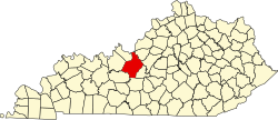
Established in 1793, Hardin County was named for Colonel John Hardin, an Indian fighter who worked with tribes in the local area. In a few years, professional men and tradesmen came to live in the area. In 1793, Colonel Andrew Hynes had 30 acres (12ha) (until then known as the "Severn's Valley Settlement"[4]) surveyed and laid off into lots and streets to establish Elizabethtown. Named in honor of his wife, Elizabethtown was legally established in 1797.[5][6]
Thomas Lincoln helped Samuel Haycraft build a millrace at Haycraft's mill on Valley Creek. After Lincoln married Nancy Hanks in 1806, they lived in a log cabin built in Elizabethtown. Their daughter, Sarah, was born there in 1807. Soon after, they moved to the Sinking Spring Farm, where Abraham Lincoln was born in 1809. Thomas Lincoln took his family to Indiana in 1816. After his wife died in 1818, he returned to Elizabethtown and married Sarah Bush Johnston, widowed since 1816. She and her three children accompanied Thomas back to Indiana, where Sarah was stepmother to Thomas' two children.[citation needed]
On March 5, 1850, the Commonwealth of Kentucky granted a charter to the Louisville and Nashville Railroad Company authorizing it to raise funds and built a railroad from Louisville to the Tennessee state line in the direction of Nashville. John L. Helm, the grandson of Capt. Thomas Helm, became the president of the railroad in October 1854; he directed construction of the main stem of the rail line through Elizabethtown. The rail line was completed to Elizabethtown in 1858, with the first train arriving on June 15, 1858. The opening of the railroad brought economic growth to Elizabethtown, which became an important trade center along the railroad and a strategic point during the Civil War.[citation needed]
On December 27, 1862, Confederate General John Hunt Morgan and his 3,000-man cavalry attacked Elizabethtown. During the battle, more than 100 cannonballs were fired into the town. Although he successfully captured Elizabethtown, Morgan's chief goal was to disrupt the railroad and northern transportation. He proceeded north along the railroad, burning trestles and destroying sections of the track. After the battle, one cannonball was found lodged in the side of a building on the public square. After the building burned in 1887 and was rebuilt, the cannonball was replaced in the side wall, as close to its original site as possible, where it remains in the present day. It is located in the Joey Lee building, which is located on the historic town square. The building is currently owned and houses the office of attorney Roger T. Rigney, it also features a plaquard noting the cannonball and the history behind it out front.[citation needed]
From 1871 to 1873 during the Reconstruction Era, the Seventh Cavalry and a battalion of the Fourth Infantry, led by General George Armstrong Custer, were stationed in Elizabethtown. The military were assigned to suppress the local Ku Klux Klan under the Enforcement Acts, as their members had been attacking freedmen and other Republicans. They also broke up illegal distilleries, which began to flourish in the South after the Civil War. General Custer and his wife Elizabeth lived in a small cottage behind Aunt Beck Hill's boarding house, now known as the Brown-Pusey House.[citation needed]
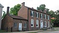
A banner remembers John Hunt Morgan's role in the history of Elizabethtown, KY. A Confederate cannonball is embedded in the blue building at left (the ball is visible just below and to the left of the nearest second-story window).
Geography
Elizabethtown is in east-central Hardin County, about 15 miles (24km) south of Fort Knox. Interstate 65 passes through the southeast side of the city, leading north-northeast 30 miles (48km) to Louisville and southwest 80 miles (130km) to Bowling Green. The Western Kentucky Parkway starts at I-65 in Elizabethtown and leads west 138 miles (222km) to Eddyville. To the east, the Bluegrass Parkway leads 105 miles (169km) to Lexington.
According to the United States Census Bureau, Elizabethtown has a total area of 25.8 square miles (67km2), of which 25.4 square miles (66km2) is land and 0.5 square miles (1km2) (1.77%) is water.[7]
The Elizabethtown–Fort Knox metropolitan area consists of Hardin, Meade, and Larue counties, and includes Radcliff, a city about three-fourths the size of Elizabethtown; the housing areas of the Fort Knox Military Installation; the unincorporated town of Rineyville; and other communities such as Vine Grove, Glendale, Sonora, West Point, and Upton.
Climate
The climate in this area is characterized by hot, humid summers and generally mild to cool winters. According to the Köppen Climate Classification system, Elizabethtown has a humid subtropical climate, abbreviated "Cfa" on climate maps.[8]
As of the census of 2010,[10] there were 28,531 people, 15,711 households, and 9,345 families residing in the city. The population density was 936.6/mi2 (361.6/km2). There were 12,664 housing units at an average density of 490.5/mi2 (189.4/km2). The racial makeup of the city was 80.4% White (78.1% non-Hispanic), 19.6% African American, 0.34% Native American or Alaska Native, 2.6% Asian, 0.18% Pacific Islander, 1.3% from other races, and 3.4% from two or more races. Hispanics or Latinos of any race were 4.3% of the population.
There were 15,711 households, out of which 30.5% had children under the age of 18 living with them, 43.2% were married couples living together, 15.1% had a female householder with no husband present, 4.4% had a male householder with no wife present, and 37.3% were non-families. 32.1% of all households were made up of individuals, and 10.9% had someone living alone who was 65 years of age or older. The average household size was 2.34 and the average family size was 2.94.
The age distribution was 25.1% under 18, 9.8% from 18 to 24, 27.5% from 25 to 44, 24.4% from 45 to 64, and 13.2% who were 65 or older. The median age was 35.4 years. For every 100 females, there were 91.9 males. For every 100 females age 18 and over, there were 87.4 males.
Full economic data for Kentucky locations from the 2010 Census has not yet been released.[needs update?] As of the 2010 Census, median income for a household in the city was $40,720, and the median income for a family was $54,699. Full-time male workers had a median income of $43,406 versus $30,310 for females. The per capita income for the city was $23,627. As of the 2000 Census,[11] about 8.5% of families and 10.5% of the population were below the poverty line, including 14.6% of those under age 18 and 9.1% of those age 65 or over.
The first Baptist settlement west of the Allegheny Mountains was in Elizabethtown at Severns Valley Baptist Church, named after the original name of Elizabethtown. Catholics came west from Nelson County and settled at Colesburg at St. Clare Parish before coming to St. James Parish in Elizabethtown. Lucinda Helm helped bring United Methodists into Elizabethtown, and they immortalized her in naming the Helm Memorial United Methodist Church, today simply called MUMC. More than 12 denominations are represented by over 100 churches in Elizabethtown.[citation needed]
Culture
The town is regionally referred to as "E-town" (sometimes with an apostrophe in place of the dash). It is one of two larger towns (the other being Bowling Green, Kentucky) along I-65 between Louisville and Nashville.
The movie Elizabethtown (2005) was named after the town; most of the footage was filmed in Versailles and Louisville because Elizabethtown has lost much of its historic architecture in recent years due to commercial development.[citation needed]
Alcohol sales
Elizabethtown is officially classified by the Kentucky Department of Alcoholic Beverage Control (ABC) as being in a "moist county". Under ABC terminology, "moist" indicates that at least one city within a county has approved packaged alcohol sales. In popular usage, the term "moist" more often refers to the city's former status as allowing by-the-drink sales in restaurants, but not package sales.[citation needed]
Despite the county being a dry county, alcoholic drink sales have long been allowed in restaurants seating at least 100 diners and deriving at least 70% of their total sales from food. Beer, wine and spirits can be purchased at licensed liquor stores, drug stores and grocery outlets, beer can be purchased at most convenience stores . The locals classify this as a "damp" or "moist" county. In 2011, the residents of Elizabethtown, Radcliff, and Vine Grove voted to allow properly licensed businesses to sell package liquor, wine, and beer.[12]
Transportation
The city is served by the Elizabethtown Regional Airport (EKX), and the Elizabethtown Airport Board was as of 2013 exploring options to bring commercial services to the city.[13]
Education
Water tower near Panther Baseball Park in Elizabethtown
Although New Highland Elementary, Bluegrass Middle School, and John Hardin High School have an Elizabethtown mailing address, and some Elizabethtown residents are zoned into those schools, they are actually within the city limits of neighboring Radcliff.[14] Similarly, the HCS headquarters is located in Radcliff but served by the Elizabethtown post office.[15] Conversely, Central Hardin High is within the city limits of Elizabethtown but has a mailing address of Cecilia.[citation needed]
12"State Primary Road System: Hardin County"(PDF). Kentucky Transportation Cabinet. July 2011. Archived(PDF) from the original on July 14, 2014. Retrieved August 5, 2011. On this map, Elizabethtown is displayed with a pink background and Radcliff in green. For Central Hardin's location, follow U.S. 62 west of downtown Elizabethtown. For John Hardin High's location, zoom in to the region where the two cities meet.
↑"補習授業校リスト" (Archive). Consulate General of Japan in Nashville. Retrieved February 15, 2015. "(2)エリザ スタウン日本人補習校 (Elizabethtown Japanese School) 学校所在地 c/o Elizabethtown Community and Technical College 600 College Street Road, Elizabethtown, KY 42701"
↑HomeArchived April 1, 2015, at the Wayback Machine . Elizabethtown Japanese School. Retrieved April 5, 2015. "エリザベスタウン日本人補習校 c/o ECTC 600 College Street Road Elizabethtown, Kentucky, U.S.A."
↑Woodard, Bruce A. (1967). Diamonds in the Salt. Boulder, CO: Pruett Press. p.200.
↑"UK Wildcats – Basketball (M)". University of Kentucky – Official Athletics Site. University of Kentucky. Archived from the original on February 20, 2015. Retrieved February 20, 2015.
↑Barefoot, Daniel W. (2005). Let Us Die Like Brave Men: Behind the Dying Words of Confederate Warriors. North Carolina: John F. Blair. ISBN0-89587-311-7.
This page is based on this Wikipedia article Text is available under the CC BY-SA 4.0 license; additional terms may apply. Images, videos and audio are available under their respective licenses.