Old Stephensburg, Kentucky

Last updated

Old Stephensburg, Kentucky
USA Kentucky location map.svg
Red pog.svg
Old Stephensburg
Usa edcp location map.svg
Red pog.svg
Old Stephensburg
Coordinates: 37°36′52″N86°01′13″W / 37.61444°N 86.02028°W / 37.61444; -86.02028
Country United States
State Kentucky
County Hardin
Elevation
686 ft (209 m)
Time zone UTC-5 (Eastern (EST))
  Summer (DST) UTC-4 (EDT)
Area code(s) 270 & 364
GNIS feature ID499886 [1]

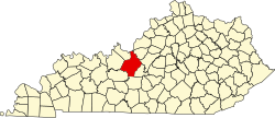
Old Stephensburg is an unincorporated community in Hardin County, Kentucky, United States. [1]

Notes

  1. 1 2 "Old Stephensburg, Kentucky". Geographic Names Information System . United States Geological Survey, United States Department of the Interior.


Related Research Articles

<span class="mw-page-title-main">Kentucky</span> U.S. state

Kentucky, officially the Commonwealth of Kentucky, is a landlocked state in the Southeastern region of the United States. Kentucky borders Illinois, Indiana, and Ohio to the north, West Virginia to the northeast, Virginia to the east, Tennessee to the south, and Missouri to the west. Its northern border is defined by the Ohio River. Its capital is Frankfort and its largest city is Louisville. As of 2020, the population was approximately 4.5 million.

<span class="mw-page-title-main">Bourbon whiskey</span> Type of American whiskey

Bourbon whiskey is a type of barrel-aged American whiskey made primarily from corn (maize). The name derives from the French House of Bourbon, although the precise source of inspiration is uncertain; contenders include Bourbon County, Kentucky, and Bourbon Street in New Orleans, both of which are named after the House of Bourbon. The name bourbon might not have been used until the 1850s, and the association with Bourbon County was not evident until the 1870s.

<span class="mw-page-title-main">Lexington, Kentucky</span> City in Kentucky, United States

Lexington is the second-most-populous city in the Commonwealth of Kentucky, and the 60th-most populous city in the United States. It is the county seat of Fayette County. By land area, it is the country's 30th-largest city.

<span class="mw-page-title-main">Louisville, Kentucky</span> Largest city in Kentucky, United States

Louisville is the most populous city in the Commonwealth of Kentucky, sixth-most populous city in the Southeast, and the 27th-most-populous city in the United States. By land area, it is the country's 24th-largest city, although by population density, it is the 265th most dense city. Louisville is the historical county seat and, since 2003, the nominal seat of Jefferson County, on the Indiana border.

<span class="mw-page-title-main">Mercer County, Kentucky</span> County in Kentucky, United States

Mercer County is a county located in the central part of the U.S. Commonwealth of Kentucky. As of the 2020 census, the population was 23,772. Its county seat is Harrodsburg. The county was formed from Lincoln County, Virginia in 1785 and is named for Revolutionary War General Hugh Mercer, who was killed at the Battle of Princeton in 1777. It was formerly a prohibition or dry county.

<span class="mw-page-title-main">Marion County, Kentucky</span> County in Kentucky, United States

Marion County is a county in the U.S. state of Kentucky. As of the 2020 census, the total population was 19,581. Its county seat is Lebanon. The county was founded in 1834 and named for Francis Marion, the American Revolutionary War hero known as the "Swamp Fox".

<span class="mw-page-title-main">Lee County, Kentucky</span> County in Kentucky, United States

Lee County is a county located in the U.S. state of Kentucky. As of the 2020 census, the population was 7,395. Its county seat is Beattyville. The county was formed in 1870 from parts of Breathitt, Estill, Owsley and Wolfe counties. The county was named for Robert E. Lee. The area of Kentucky where Lee County is located was a pro-union region of Kentucky but the legislature that created the county was controlled by former Confederates. The town of Proctor, named for the Rev. Joseph Proctor, was the first county seat. The first court was held on April 25, 1870, in the old Howerton House. The local economy at the time included coal mining, salt gathering, timber operations, and various commercial operations. It had a U.S. post office from 1843 until 1918.

<span class="mw-page-title-main">Hardin County, Kentucky</span> County in Kentucky, United States

Hardin County is a county located in the central part of the U.S. state of Kentucky. Its county seat is Elizabethtown. The county was formed in 1792. Hardin County is part of the Elizabethtown-Fort Knox, KY Metropolitan Statistical Area, as well as the Louisville/Jefferson County—Elizabethtown-Bardstown, KY-IN Combined Statistical Area. As of the 2020 census, the population was 110,702.

<span class="mw-page-title-main">Gallatin County, Kentucky</span> County in Kentucky, United States

Gallatin County, is a county located in the northern part of the U.S. state of Kentucky. Its county seat is Warsaw. The county was founded in 1798 and named for Albert Gallatin, the Secretary of the Treasury under President Thomas Jefferson. Gallatin County is included in the Cincinnati-Middletown, OH-KY-IN Metropolitan Statistical Area. It is located along the Ohio River across from Indiana.

<span class="mw-page-title-main">Crittenden County, Kentucky</span> County in Kentucky, United States

Crittenden County is a county in the U.S. state of Kentucky. At the 2020 census, the population was 8,990. Its county seat and only municipality is Marion. The county was formed in 1842 and named for John J. Crittenden, senator and future Governor of Kentucky.

<span class="mw-page-title-main">Bourbon County, Kentucky</span> County in Kentucky, United States

Bourbon County is a county located in the U.S. state of Kentucky. As of the 2020 census, the population was 20,252. Its county seat is Paris. Bourbon County is part of the Lexington-Fayette, KY Metropolitan Statistical Area. It is one of Kentucky's nine original counties, and is best known for its historical association with bourbon whiskey.

<span class="mw-page-title-main">Winchester, Kentucky</span> City in Kentucky, United States

Winchester is a home rule-class city in and the county seat of Clark County, Kentucky, United States. The population was 19,134 at the 2020 census. It is part of the Lexington-Fayette, KY Metropolitan Statistical Area. Winchester is located roughly halfway between Lexington and Mt. Sterling.

<span class="mw-page-title-main">Bardstown, Kentucky</span> City in Kentucky, United States

Bardstown is a home rule-class city in Nelson County, Kentucky, United States. The population was 13,567 in the 2020 census. It is the county seat of Nelson County.

<span class="mw-page-title-main">Mint julep</span> Cocktail

Mint julep is an alcoholic cocktail, consisting primarily of bourbon, sugar, water, crushed or shaved ice, and fresh mint. As a bourbon-based cocktail, it is associated with the American South and the cuisine of the Southern United States in general, in particular as a symbol of the Kentucky Derby.

<span class="mw-page-title-main">Felix Grundy</span> American politician (1777–1840)

Felix Grundy was an American attorney and politician who served as the 13th United States Attorney General. He also had served several terms as a congressman and as a U.S. senator from Tennessee. He was known for his success as a criminal lawyer who attracted crowds when he served on the defense.

<span class="mw-page-title-main">My Old Kentucky Home State Park</span> State park in Kentucky, United States

My Old Kentucky Home State Park is a state park located in Bardstown, Kentucky, United States. The park's centerpiece is Federal Hill, a former plantation home owned by United States Senator John Rowan in 1795. During the Rowan family's occupation, the mansion became a meeting place for local politicians and hosted several visiting dignitaries.

<span class="mw-page-title-main">Glendale, Kentucky</span> Unincorporated community in Kentucky, United States

Glendale is an unincorporated community in Hardin County, Kentucky, United States. It is included in the Elizabethtown, Kentucky Metropolitan Statistical Area.

<span class="mw-page-title-main">Elizabethtown metropolitan area</span> Metropolitan Statistical Area in Kentucky, United States

The Elizabethtown–Fort Knox Metropolitan Statistical Area, as defined by the United States Census Bureau, is an area consisting of two counties in Kentucky, anchored by the city of Elizabethtown and the nearby Fort Knox Army post. As of the 2020 census, the MSA had a population of 155,572.

Richard Porter Giles was an American attorney and Democratic politician from Missouri.

Stephensburg is an unincorporated community in Hardin County, Kentucky, United States.