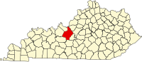
Hardin County is a county located in the U.S. state of Kentucky. Its county seat is at Elizabethtown. The county was formed in 1792.

Breckinridge County is a county located in the Commonwealth of Kentucky. As of the 2010 census, the population was 20,059. Its county seat is Hardinsburg, Kentucky. The county was named for John Breckinridge (1760–1806), a Kentucky Attorney General, state legislator, United States Senator, and United States Attorney General. It was the 38th Kentucky county in order of formation.

Hardin County is a county located in the U.S. state of Illinois. According to the 2010 census, it has a population of 4,320, making it the least populous county in Illinois. Its county seat is Elizabethtown. Hardin County is located in the part of the state known as Little Egypt. Hardin County was named for Hardin County, Kentucky, which was named in honor of Colonel John Hardin, an officer in the American Revolutionary War and the Northwest Indian War.
Hardinsburg is a home rule-class city in Breckinridge County, Kentucky, in the United States. It is the seat of its county. The population was 2,343 at the 2010 census. Hardinsburg was named after Captain William Hardin.
Elizabethtown is a home rule-class city and the county seat of Hardin County, Kentucky, United States. The population was 28,531 at the 2010 census, and was estimated at 29,906 by the U.S. Census Bureau in 2016, making it the 11th-largest city in the state. It is included in the Elizabethtown–Fort Knox, Kentucky Metropolitan Statistical Area, which is included in the Louisville/Jefferson County–Elizabethtown–Madison, Kentucky-Indiana Combined Statistical Area.

The Louisville metropolitan area or Kentuckiana, also known as the Louisville–Jefferson County, Kentucky–Indiana, metropolitan statistical area, is the 45th largest metropolitan statistical area (MSA) in the United States. The principal city is Louisville, Kentucky.

Martin D. Hardin was a politician and lawyer from Kentucky. Born in Pennsylvania, his family immigrated to Kentucky when he was still young. He studied law under George Nicholas and commenced practice at Richmond, Kentucky. His cousin, future U.S. Representative Benjamin Hardin, studied in his law office. He represented Madison County in the Kentucky House of Representatives for a single term.

This is a list of properties and historic districts in Kentucky that are listed on the National Register of Historic Places. There are listings in all of Kentucky's 120 counties.
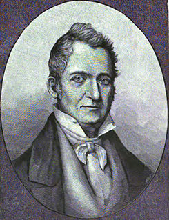
Benjamin Hardin was a United States Representative from Kentucky. Martin Davis Hardin was his cousin. He was born at the Georges Creek settlement on the Monongahela River, Westmoreland County, Pennsylvania and then moved with his parents to Washington County, Kentucky in 1788. Hardin attended the schools of Nelson and Washington Counties, Kentucky before studying law. He was admitted to the bar in 1806 and commenced practice in Elizabethtown and Bardstown, Nelson County, Kentucky and he settled in Bardstown, Kentucky in 1808.
The Elizabethtown–Fort Knox Metropolitan Statistical Area, as defined by the United States Census Bureau, is an area consisting of two counties in Kentucky, anchored by the city of Elizabethtown and the nearby Fort Knox Army post. As of the 2000 census, the MSA had a population of 107,547.

This is a list of the National Register of Historic Places listings in Hardin County, Kentucky.
Chenault House may refer to:

Big Spring, Kentucky is an unincorporated community in Breckinridge County, Meade County, and Hardin County in the U.S. state of Kentucky.
White Mills is an unincorporated community in Hardin County, Kentucky, United States.
Nolin is an unincorporated community in Hardin County, Kentucky, United States. Nolin is located along a railroad 10 miles (16 km) south of Elizabethtown. The Nolin Banking Company, which is listed on the National Register of Historic Places, is located in Nolin.
Saint John is an unincorporated community in Hardin County, Kentucky, United States. Saint John is located on Kentucky Route 1357, 5.6 miles (9.0 km) west of Elizabethtown.
Hardin Springs is an unincorporated community in Hardin County, Kentucky, United States. Hardin Springs is located on Kentucky Route 84, 22.4 miles (36.0 km) west-southwest of Elizabethtown. The Hardin Springs School, which is listed on the National Register of Historic Places, is located in Hardin Springs.
Kentucky Route 333 (KY 333) is a 22.300-mile-long (35.888 km) state highway in the U.S. state of Kentucky. The highway connects mostly rural areas of Breckinridge, Meade, and Hardin counties with Big Spring. Signage at its western end is north–south, but at its eastern end is east–west. However, the Kentucky Transportation Cabinet designates the entire highway as an east–west route.
Kentucky Route 434 (KY 434) is a 13.237-mile-long (21.303 km) state highway in the U.S. state of Kentucky. The highway connects mostly rural areas of Hardin and Bullitt counties with Radcliff, Fort Knox, and Lebanon Junction.
Kraft is an unincorporated community in Hardin County, Kentucky, United States.