Muldraugh, Kentucky

Last updated

Muldraugh, Kentucky
Nickname: 
"The Gateway to Gold" [1]
Hardin County Kentucky Incorporated and Unincorporated areas Muldraugh Highlighted 2154480.svg
Location in Hardin County, Kentucky
Coordinates: 37°56′13″N85°59′29″W / 37.93694°N 85.99139°W / 37.93694; -85.99139
Country United States
State Kentucky
Counties Meade, Hardin
Incorporated1852 [2]
Area
[3]
  Total0.52 sq mi (1.36 km2)
  Land0.52 sq mi (1.35 km2)
  Water0.00 sq mi (0.00 km2)
Elevation
738 ft (225 m)
Population
 (2020) [4]
  Total1,040
  Density1,988.53/sq mi (768.25/km2)
Time zone UTC-5 (Eastern (EST))
  Summer (DST) UTC-4 (EDT)
ZIP code
40155
Area code 502
FIPS code 21-54480
GNIS feature ID0499075
Website muldraugh.ky.gov

Muldraugh is a home rule-class city in Meade and Hardin counties in the U.S. state of Kentucky. It lies on U.S. Route 31W north of Elizabethtown. The city limits are completely encompassed by the Fort Knox army base. The population was 1,040 as of the 2020 census. [4] The city is part of the Elizabethtown–Fort Knox Metropolitan Area.

Contents

Geography

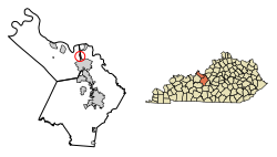
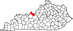
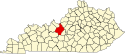
Muldraugh is in eastern Meade County, with a small portion at the south end extending east into Hardin County. U.S. Routes 31W and 60 form the western border of the city. The highway leads north 27 miles (43 km) to Louisville. US 31W leads south 18 miles (29 km) to Elizabethtown, while US 60 turns west just south of the Muldraugh city limits and leads 34 miles (55 km) to Hardinsburg. Brandenburg Station Road, the north entrance to Fort Knox, has an interchange with US 31W and 60 at the south end of Muldraugh.

According to the United States Census Bureau, the city has a total area of 0.52 square miles (1.35 km2), all land. [3]

Muldraugh is located just south of Muldraugh Hill at 37°56′13″N85°59′29″W / 37.93694°N 85.99139°W / 37.93694; -85.99139 (37.936975, -85.991414). [5] The road coming to the town from the north (now U.S. 31W and U.S. 60) is very steep, which is the source of the town's name: early on, reaching the area required a "mule-drawn" wagon.[ citation needed ]

Demographics

Historical population
CensusPop.Note
1960 1,743
1970 1,7731.7%
1980 1,752−1.2%
1990 1,376−21.5%
2000 1,298−5.7%
2010 947−27.0%
2020 1,0409.8%
U.S. Decennial Census [6]

As of the census [7] of 2000, there were 1,298 people, 519 households, and 319 families residing in the city. The population density was 2,264.6 inhabitants per square mile (874.4/km2). There were 635 housing units at an average density of 1,107.9 per square mile (427.8/km2). The racial makeup of the city was 82.36% White, 9.94% African American, 1.39% Native American, 1.00% Asian, 0.08% Pacific Islander, 2.16% from other races, and 3.08% from two or more races. Hispanics or Latinos of any race were 7.01% of the population.

There were 519 households, out of which 34.7% had children under the age of 18 living with them, 38.2% were married couples living together, 17.0% had a female householder with no husband present, and 38.5% were non-families. 30.8% of all households were made up of individuals, and 6.0% had someone living alone who was 65 years of age or older. The average household size was 2.50 and the average family size was 3.12.

The age distribution was 28.2% under the age of 18, 13.6% from 18 to 24, 34.7% from 25 to 44, 16.4% from 45 to 64, and 7.1% who were 65 years of age or older. The median age was 29 years. For every 100 females, there were 104.4 males. For every 100 females age 18 and over, there were 107.6 males.

The median income for a household in the city was $29,712, and the median income for a family was $31,625. Males had a median income of $27,955 versus $20,450 for females. The per capita income for the city was $13,318. About 19.5% of families and 20.7% of the population were below the poverty line, including 27.6% of those under age 18 and 23.9% of those age 65 or over.

In the 1964 James Bond movie Goldfinger , a section of Main Street appears in the film. In the scene where Goldfinger's men are driving in Army trucks on their way to Fort Knox, they can be seen coming out of Harris Street turning onto Main Street. The red brick house on Harris Street, the white cinder block building on the corner of Harris and Main, and the Used Cars sign in the background are still there today.

Muldraugh and its neighboring town West Point both serve as starting towns [8] for the 2013 early-access open-world zombie survival-horror video game Project Zomboid . While in-game, the player can explore and loot a close representation of the towns that include both existing and fictional landmarks and locations. It is possible to leave these towns and follow the Dixie Highway north, where one will eventually end upon the quarantined city of Louisville , the most extensive and diverse settlement within the game.

Related Research Articles

<span class="mw-page-title-main">Fort Knox</span> United States Army post in Kentucky, United States

Fort Knox is a United States Army installation in Kentucky, south of Louisville and north of Elizabethtown. It is adjacent to the United States Bullion Depository, which is used to house a large portion of the United States' official gold reserves, and with which it is often conflated. The 109,000-acre base covers parts of Bullitt, Hardin and Meade counties. It currently holds the Army Human Resources Center of Excellence, including the Army Human Resources Command. It is named in honor of Henry Knox, Chief of Artillery in the American Revolutionary War and the first United States Secretary of War.

<span class="mw-page-title-main">Meade County, Kentucky</span> County in Kentucky, United States

Meade County is a county located in the U.S. state of Kentucky. As of the 2020 census, the population was 30,003. Its county seat is Brandenburg. The county was founded December 17, 1823, and named for Captain James M. Meade, who was killed in action at the Battle of River Raisin during the War of 1812. Meade County is part of the Elizabethtown-Fort Knox, KY Metropolitan Statistical Area, which is included in the Louisville/Jefferson County-Elizabethtown-Madison, KY-IN Combined Statistical Area.

<span class="mw-page-title-main">LaRue County, Kentucky</span> County in Kentucky, United States

LaRue County is a county in the central region of the U.S. state of Kentucky, outside the Bluegrass Region and larger population centers. As of the 2020 census, the population was 14,867. Its county seat is Hodgenville, which is best known as the birthplace of United States President Abraham Lincoln. The county was established on March 4, 1843, from the southeast portion of Hardin County. It was named for John P. LaRue, an early settler. LaRue County is included in the Elizabethtown-Fort Knox, KY Metropolitan Statistical Area, which is also included in the Louisville/Jefferson County-Elizabethtown-Bardstown, KY-IN Combined Statistical Area. It is a dry county.

<span class="mw-page-title-main">Hardin County, Kentucky</span> County in Kentucky, United States

Hardin County is a county located in the central part of the U.S. state of Kentucky. Its county seat is Elizabethtown. The county was formed in 1792. Hardin County is part of the Elizabethtown-Fort Knox, KY Metropolitan Statistical Area, as well as the Louisville/Jefferson County—Elizabethtown-Bardstown, KY-IN Combined Statistical Area. As of the 2020 census, the population was 110,702.

<span class="mw-page-title-main">Bullitt County, Kentucky</span> County in Kentucky, United States

Bullitt County is a county located in the north central portion of the U.S. state of Kentucky. As of the 2020 census, the population was 82,217. Its county seat is Shepherdsville. The county was founded in 1796. Located just south of the city of Louisville, Bullitt County is included in the Louisville/Jefferson County, KY-IN Metropolitan Statistical Area, commonly known as Kentuckiana. The western fifth of the county is part of the United States Army post of Fort Knox and is reserved for military training.

<span class="mw-page-title-main">Elizabethtown, Illinois</span> Village in Illinois, United States

Elizabethtown is a village in and the county seat of Hardin County, Illinois, United States, along the Ohio River. The population was 299 at the 2010 census, down from 348 at the 2000 census. It is the least-populous county seat in the state.

<span class="mw-page-title-main">Cave City, Kentucky</span> City in Kentucky, United States

Cave City is a home rule-class city in Barren County, Kentucky, in the United States. The population was 2,356 at the 2020 census. It is part of the Glasgow Micropolitan Statistical Area.

<span class="mw-page-title-main">Radcliff, Kentucky</span> City in Kentucky, United States

Radcliff is a home rule-class city in Hardin County, Kentucky, in the United States. The population was 23,042 as of the 2020 Census, up from 21,692 from the 2010 census.

<span class="mw-page-title-main">Sonora, Kentucky</span> City in Kentucky, United States

Sonora is a home rule-class city in Hardin County, Kentucky, United States. The population was 565 as of the 2020 Census, up from 513 from the 2010 census,. It is included in the Elizabethtown, Kentucky Metropolitan Statistical Area.

<span class="mw-page-title-main">Vine Grove, Kentucky</span> City in Kentucky, United States

Vine Grove is a home rule-class city in Hardin County, Kentucky, United States. The population was 6,559 as of the 2020 Census, up from 4,520 at the 2010 census,. It is part of the Elizabethtown–Fort Knox Metropolitan Statistical Area.

<span class="mw-page-title-main">West Point, Kentucky</span> City in Kentucky, United States

West Point is a home rule-class city in Hardin County, Kentucky, United States, near the edge of Fort Knox military reservation on Dixie Highway. It is located in a former meander bend of the Ohio River. The population was 952 as of the 2020 Census, up from 797 from the 2010 census,but still down from 1,100 at the 2000 census.

<span class="mw-page-title-main">Bonnieville, Kentucky</span> City in Kentucky, United States

Bonnieville is a home rule-class city in Hart County, Kentucky, in the United States. The population was 255 at the 2010 census.

<span class="mw-page-title-main">Munfordville, Kentucky</span> City in Kentucky, United States

Munfordville is a home rule-class city in, and the county seat of, Hart County, Kentucky, United States. The population was 1,615 at the 2010 U.S. census.

<span class="mw-page-title-main">Bradfordsville, Kentucky</span> City in Kentucky, United States

Bradfordsville is a home rule-class city in Marion County, Kentucky, in the United States. The population was 270 at the time of the 2020 census.

<span class="mw-page-title-main">Raywick, Kentucky</span> City in Kentucky, United States

Raywick is a home rule-class city in Marion County, Kentucky, United States. The population was 155 at the 2020 census.

<span class="mw-page-title-main">Calhoun, Kentucky</span> City in Kentucky, United States

Calhoun is a home rule-class city in McLean County, Kentucky, United States. The population was 725 at the 2020 census. It is the county seat of McLean County. It is included in the Owensboro, Kentucky Metropolitan Statistical Area.

<span class="mw-page-title-main">Ekron, Kentucky</span> City in Kentucky, United States

Ekron is a home rule-class city in Meade County, Kentucky, United States. The population was 175 at the 2020 census.

<span class="mw-page-title-main">Oakland, Kentucky</span> City in Kentucky, United States

Oakland is a home rule-class city in Warren County, Kentucky, in the United States. The population was 198 during the 2020 Census. It is included in the Bowling Green metropolitan area.

<span class="mw-page-title-main">Upton, Kentucky</span> City in Kentucky, United States

Upton is a home rule-class city in Hardin and LaRue counties in the U.S. state of Kentucky. The population was 704 as of the 2020 Census, up from 683 from the 2010 census. Its entire area is included in the Elizabethtown–Fort Knox Metropolitan Statistical Area.

The Elizabethtown–Fort Knox Metropolitan Statistical Area, as defined by the United States Census Bureau, is an area consisting of two counties in Kentucky, anchored by the city of Elizabethtown and the nearby Fort Knox Army post. As of the 2020 census, the MSA had a population of 155,572.

References

  1. "Welcome to the City of Muldraugh, the gateway to gold!". City of Muldraugh, KY. Retrieved May 17, 2023.
  2. Commonwealth of Kentucky. Office of the Secretary of State. Land Office. "Muldraugh, Kentucky". Accessed 26 August 2013.
  3. 1 2 "2022 U.S. Gazetteer Files: Kentucky". United States Census Bureau. Retrieved May 17, 2023.
  4. 1 2 "P1. Race – Muldraugh city, Kentucky: 2020 DEC Redistricting Data (PL 94-171)". U.S. Census Bureau. Retrieved May 17, 2023.
  5. "US Gazetteer files: 2010, 2000, and 1990". United States Census Bureau. February 12, 2011. Retrieved April 23, 2011.
  6. "Census of Population and Housing". Census.gov. Retrieved June 4, 2015.
  7. "U.S. Census website". United States Census Bureau . Retrieved January 31, 2008.
  8. "Project Zomboid interview: on Steam early access, survival clothing and top modders". pcgamer.com. PC Gamer. Retrieved August 5, 2014.