White Mills, Kentucky | |
|---|---|
 White Mills  White Mills | |
| Coordinates: 37°33′19″N86°1′56″W / 37.55528°N 86.03222°W | |
| Country | United States |
| State | Kentucky |
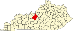
| County | Hardin |
| Elevation | 614 ft (187 m) |
| Time zone | UTC-5 (Eastern (EST)) |
| • Summer (DST) | UTC-4 (EST) |
| ZIP codes | 42788 |
| Area codes | 270 & 364 |
| GNIS feature ID | 506591 [1] |
White Mills is an unincorporated community in Hardin County, Kentucky, United States.