Sonora, Kentucky

Last updated

Sonora, Kentucky
Sonora-Main-84-ky.jpg
Buildings along Main Street
Hardin County Kentucky Incorporated and Unincorporated areas Sonora Highlighted 2171724.svg
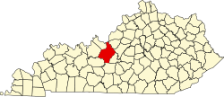
Location of Sonora in Hardin County, Kentucky.
Coordinates: 37°31′33″N85°53′40″W / 37.52583°N 85.89444°W / 37.52583; -85.89444
Country United States
State Kentucky
County Hardin
Area
[1]
  Total1.36 sq mi (3.53 km2)
  Land1.36 sq mi (3.51 km2)
  Water0.01 sq mi (0.02 km2)
Elevation
725 ft (221 m)
Population
 (2020)
  Total565
  Density416.67/sq mi (160.90/km2)
Time zone UTC-5 (Eastern (EST))
  Summer (DST) UTC-4 (EDT)
ZIP code
42776
Area code(s) 270 & 364
FIPS code 21-71724
GNIS feature ID0503878

Sonora is a home rule-class city in Hardin County, Kentucky, United States. The population was 565 as of the 2020 Census, up from 513 from the 2010 census, [2] . It is included in the Elizabethtown, Kentucky Metropolitan Statistical Area.

Contents

History

Sonora began as an L&N Railroad construction camp known as "Bucksnort" in the late 1850s. This name is believed to have been inspired by the sounds of early locomotives, which the workers thought resembled deer snorts. [3] When a depot was established at the site in 1859, the name was changed to "Sonora". This may have referred to Sonora, Mexico, the home of a railroad contractor. [3]

U.S. Navy Master Diver Carl Brashear was born in nearby Tonieville and raised in Sonora.

Geography

Sonora is located in southeastern Hardin County at 37°31′33″N85°53′40″W / 37.52583°N 85.89444°W / 37.52583; -85.89444 (37.525783, -85.894373). [4] The city is concentrated around the intersection of Kentucky Route 84 and Kentucky Route 720, with its municipal boundaries stretching eastward to the Hardin-LaRue county line. Interstate 65 passes through the eastern end of the city, with access from Exit 81. I-65 leads north 13 miles (21 km) to Elizabethtown, the county seat, and south 18 miles (29 km) to Munfordville.

According to the United States Census Bureau, the city has a total area of 1.2 square miles (3.0 km2), of which 0.01 square miles (0.03 km2), or 0.98%, are water. [2]

Demographics

2020 census

As of the 2020 census, there were 565 people.

2000 census

Historical population
CensusPop.Note
1870 266
1880 2898.6%
1890 228−21.1%
1900 25612.3%
1910 250−2.3%
1920 2749.6%
1930 248−9.5%
1940 30021.0%
1950 292−2.7%
1960 268−8.2%
1970 39045.5%
1980 4166.7%
1990 295−29.1%
2000 35018.6%
2010 51346.6%
2020 56510.1%
U.S. Decennial Census [5]

At the 2000 census, [6] there were 350 people, 138 households and 85 families residing in the city. The population density was 423.3 inhabitants per square mile (163.4/km2). There were 159 housing units at an average density of 192.3 per square mile (74.2/km2). The racial makeup of the city was 94.86% White, 2.86% African American, 0.29% Native American, 0.29% Asian, and 1.71% from two or more races.

There were 138 households, of which 31.9% had children under the age of 18 living with them, 48.6% were married couples living together, 10.1% had a female householder with no husband present, and 37.7% were non-families. 32.6% of all households were made up of individuals, and 18.8% had someone living alone who was 65 years of age or older. The average household size was 2.51 and the average family size was 3.22.

The age distribution was 26.6% under the age of 18, 8.0% from 18 to 24, 27.7% from 25 to 44, 18.6% from 45 to 64, and 19.1% who were 65 years of age or older. The median age was 36 years. For every 100 females, there were 81.3 males. For every 100 females age 18 and over, there were 86.2 males.

The median household income was $27,361 and the median family income was $37,500. Males had a median income of $28,438 and females $14,038. The per capita income was $13,554. About 6.1% of families and 10.6% of the population were below the poverty line, including 6.3% of those under age 18 and 11.9% of those age 65 or over.

Related Research Articles

<span class="mw-page-title-main">Meade County, Kentucky</span> County in Kentucky, United States

Meade County is a county located in the U.S. state of Kentucky. As of the 2020 census, the population was 30,003. Its county seat is Brandenburg. The county was founded December 17, 1823, and named for Captain James M. Meade, who was killed in action at the Battle of River Raisin during the War of 1812. Meade County is part of the Elizabethtown-Fort Knox, KY Metropolitan Statistical Area, which is included in the Louisville/Jefferson County-Elizabethtown-Madison, KY-IN Combined Statistical Area.

<span class="mw-page-title-main">LaRue County, Kentucky</span> County in Kentucky, United States

LaRue County is a county in the central region of the U.S. state of Kentucky, outside the Bluegrass Region and larger population centers. As of the 2020 census, the population was 14,867. Its county seat is Hodgenville, which is best known as the birthplace of United States President Abraham Lincoln. The county was established on March 4, 1843, from the southeast portion of Hardin County. It was named for John P. LaRue, an early settler. LaRue County is included in the Elizabethtown-Fort Knox, KY Metropolitan Statistical Area, which is also included in the Louisville/Jefferson County-Elizabethtown-Bardstown, KY-IN Combined Statistical Area. It is a dry county.

<span class="mw-page-title-main">Hardin County, Kentucky</span> County in Kentucky, United States

Hardin County is a county located in the central part of the U.S. state of Kentucky. Its county seat is Elizabethtown. The county was formed in 1792. Hardin County is part of the Elizabethtown-Fort Knox, KY Metropolitan Statistical Area, as well as the Louisville/Jefferson County—Elizabethtown-Bardstown, KY-IN Combined Statistical Area. As of the 2020 census, the population was 110,702.

<span class="mw-page-title-main">Hardin County, Illinois</span> County in Illinois, United States

Hardin County is a county located in the U.S. state of Illinois. According to the 2020 census, it has a population of 3,649, making it the least populous county in Illinois. Its county seat is Elizabethtown. Hardin County is located in the part of the state known as Little Egypt. Hardin County was named for Hardin County, Kentucky, which was named in honor of Colonel John Hardin, an officer in the American Revolutionary War and the Northwest Indian War.

Newhalen is a city in Lake and Peninsula Borough, Alaska, United States. At the 2020 census, the population was 168.

<span class="mw-page-title-main">Jacob City, Florida</span> City in Florida, United States

Jacob City is a city in Jackson County, Florida, United States. The city is population is predominantly African American, and located on the Florida Panhandle in North Florida. The population was 217 at the 2020 census.

<span class="mw-page-title-main">Elizabethtown, Illinois</span> Village in Illinois, United States

Elizabethtown is a village in and the county seat of Hardin County, Illinois, United States, along the Ohio River. The population was 299 at the 2010 census, down from 348 at the 2000 census. It is the least-populous county seat in the state.

<span class="mw-page-title-main">Rosiclare, Illinois</span> City in Illinois, United States

Rosiclare is a city in Hardin County, Illinois, along the Ohio River. The population was 1,160 at the 2010 census, down from 1,213 at the 2000 census.

<span class="mw-page-title-main">Hardinsburg, Kentucky</span> City in Kentucky, United States

Hardinsburg is a home rule-class city in Breckinridge County, Kentucky, in the United States. It is the seat of its county. The population was 2,343 at the 2010 census. Hardinsburg was named after Captain William Hardin.

<span class="mw-page-title-main">Elizabethtown, Kentucky</span> City in Kentucky, United States

Elizabethtown is a home rule-class city and the county seat of Hardin County, Kentucky, United States. The population was 28,531 at the 2010 census, and was estimated at 31,394 by the U.S. Census Bureau in 2020, making it the 11th-largest city in the state. It is included in the Elizabethtown–Fort Knox, Kentucky Metropolitan Statistical Area, which is included in the Louisville/Jefferson County–Elizabethtown–Madison, Kentucky-Indiana Combined Statistical Area. The Elizabethtown Metropolitan area had a 2019 estimated population of 153,057, making it the 5th-largest metropolitan area in the state.

<span class="mw-page-title-main">Radcliff, Kentucky</span> City in Kentucky, United States

Radcliff is a home rule-class city in Hardin County, Kentucky, in the United States. The population was 23,042 as of the 2020 Census, up from 21,692 from the 2010 census.

<span class="mw-page-title-main">Vine Grove, Kentucky</span> City in Kentucky, United States

Vine Grove is a home rule-class city in Hardin County, Kentucky, United States. The population was 6,559 as of the 2020 Census, up from 4,520 at the 2010 census,. It is part of the Elizabethtown–Fort Knox Metropolitan Statistical Area.

<span class="mw-page-title-main">West Point, Kentucky</span> City in Kentucky, United States

West Point is a home rule-class city in Hardin County, Kentucky, United States, near the edge of Fort Knox military reservation on Dixie Highway. It is located in a former meander bend of the Ohio River. The population was 952 as of the 2020 Census, up from 797 from the 2010 census, but still down from 1,100 at the 2000 census.

<span class="mw-page-title-main">Munfordville, Kentucky</span> City in Kentucky, United States

Munfordville is a home rule-class city in, and the county seat of, Hart County, Kentucky, United States. The population was 1,615 at the 2010 U.S. census.

<span class="mw-page-title-main">Nortonville, Kentucky</span> City in Kentucky, United States

Nortonville is a home rule-class city in Hopkins County, Kentucky, in the United States. The population was 1,204 as of the 2010 census.

Whipps Millgate is a former city in Jefferson County, Kentucky, United States. The population was 415 at the 2000 census. The City of Whipps Millgate was incorporated on April 26, 1969, it was dissolved and annexed by the City of Lyndon, Kentucky on July 1, 2001.

<span class="mw-page-title-main">Hardin, Kentucky</span> City in Kentucky, United States

Hardin is a home rule-class city in Marshall County, Kentucky, United States. The population was 580 at the 2020 census.

<span class="mw-page-title-main">Centertown, Kentucky</span> City in Kentucky, United States

Centertown is a home rule-class city in Ohio County, Kentucky, in the United States. The population was 423 at the 2010 census.

<span class="mw-page-title-main">Muldraugh, Kentucky</span> City in Kentucky, United States

Muldraugh is a home rule-class city in Meade and Hardin counties in the U.S. state of Kentucky. It lies on U.S. Route 31W north of Elizabethtown. The city limits are completely encompassed by the Fort Knox army base. The population was 1,040 as of the 2020 census. The city is part of the Elizabethtown–Fort Knox Metropolitan Area.

<span class="mw-page-title-main">Upton, Kentucky</span> City in Kentucky, United States

Upton is a home rule-class city in Hardin and LaRue counties in the U.S. state of Kentucky. The population was 704 as of the 2020 Census, up from 683 from the 2010 census. Its entire area is included in the Elizabethtown–Fort Knox Metropolitan Statistical Area.

References

  1. "2020 U.S. Gazetteer Files". United States Census Bureau. Retrieved March 18, 2022.
  2. 1 2 "Geographic Identifiers: 2010 Demographic Profile Data (G001): Sonora city, Kentucky". American Factfinder. U.S. Census Bureau. Retrieved June 27, 2017.[ dead link ]
  3. 1 2 Robert Rennick, Kentucky Place Names (University Press of Kentucky, 2013).
  4. "US Gazetteer files: 2010, 2000, and 1990". United States Census Bureau. February 12, 2011. Retrieved April 23, 2011.
  5. "Census of Population and Housing". Census.gov. Retrieved June 4, 2015.
  6. "U.S. Census website". United States Census Bureau . Retrieved January 31, 2008.