Kentucky cities are divided into two classes, which define their form of local government: first class and home rule.[2] First class cities are permitted to operate only under the mayor-council, while home rule cities may operate under the mayor-council, city commission, and city manager forms.[3][4][2] Currently, Louisville is Kentucky's only designated "first class" city.[5] However, by virtue of also having merged city-county governments, both Louisville and Lexington are treated as special cases under state law, and were permitted to retain their existing local forms of government and powers.[2]
Classes
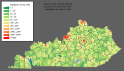
Kentucky population density by census tract (2010), showing the concentration of settlement around Jefferson, Fayette and Kentoncounties
The two-class system went into effect on January 1, 2015, following the 2014 passage of House Bill 331 by the Kentucky General Assembly and the bill's signing into law by Governor Steve Beshear.[6]
The new system replaced one in which cities were divided into six classes based on their population at the time of their classification. Before the enactment of House Bill 331, more than 400 classification-related laws affected public safety, alcohol beverage control, revenue options and others. Lexington and Fayette County are completely merged in a unitary urban county government (UCG); Louisville and other cities within Jefferson County have also merged into a single metro government. However, under state law, both major cities retained their pre-merger classification[7] before the new scheme took effect. The General Assembly had historically reclassified cities only when requested by the city government. If all cities had been reclassified in the pre-2015 scheme according to actual population, about one-third of classifications would have changed.[7] In particular, Lexington would have been classified as a first-class (Class 1) city.
Although basic city classification changed in 2015, the old classifications will remain relevant for some time. Because many provisions of state law applied only to cities of certain pre-2015 classes, House Bill 331 was explicitly written to address such issues. In certain areas of law, class-based distinctions between cities have been replaced by population-based distinctions. In certain other areas that were more controversial, the pre-2015 status quo is being maintained through a registry of cities that were covered by prior laws.[6]
Under the reformed system, Louisville is classified as first class. All other cities in the state are in the home rule class.[5]
↑Commonwealth of Kentucky. Office of the Secretary of State. Land Office. "122 County SeatsArchived March 27, 2014, at the Wayback Machine ". Accessed 15 July 2013.
↑Kleber, John (1992). The Kentucky Encyclopedia. Lexington, Kentucky: The University Press of Kentucky. ISBN0-8131-1772-0.
This page is based on this Wikipedia article Text is available under the CC BY-SA 4.0 license; additional terms may apply. Images, videos and audio are available under their respective licenses.