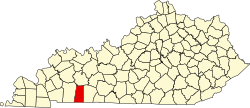
Elkton, Kentucky

Last updated

Elkton, Kentucky
Todd County KY Courthouse.png
The Todd County courthouse in the Elkton town square
Todd County Kentucky Incorporated and Unincorporated areas Elkton Highlighted 2124400.svg
Location of Elkton in Todd County, Kentucky.
Coordinates: 36°48′32″N87°9′23″W / 36.80889°N 87.15639°W / 36.80889; -87.15639
Country United States
State Kentucky
County Todd
Established1820
Government
  MayorArthur Green
Area
[1]
  Total2.55 sq mi (6.61 km2)
  Land2.55 sq mi (6.60 km2)
  Water0.00 sq mi (0.01 km2)
Elevation
623 ft (190 m)
Population
 (2020)
  Total2,056
  Estimate 
(2022) [2]
2,141
  Density806.59/sq mi (311.45/km2)
Time zone UTC-6 (CST)
  Summer (DST) UTC-5 (CDT)
ZIP Code
42220
Area code(s) 270 & 364
FIPS code 21-24400
GNIS feature ID0491697
Website www.elktonky.com

Elkton is a home rule-class city [3] in and the county seat of Todd County, Kentucky, United States. [4] The population was 2,062 at the 2010 census.

Contents

History

The city was founded by Major John Gray and established by the state assembly in 1820. It is named for the presence of an elk herd that utilized a nearby waterway and natural salt lick. [5] It was formally incorporated in 1843.

Geography

Elkton is located at 36°48′32″N87°9′23″W / 36.80889°N 87.15639°W / 36.80889; -87.15639 (36.808926, -87.156377). [6]

According to the United States Census Bureau, the city has a total area of 2.1 square miles (5.4 km2), all land.

Demographics

Historical population
CensusPop.Note
1840 474
1880 874
1890 1,15832.5%
1900 1,123−3.0%
1910 1,2289.3%
1920 1,009−17.8%
1930 951−5.7%
1940 1,21427.7%
1950 1,3128.1%
1960 1,44810.4%
1970 1,61211.3%
1980 1,81512.6%
1990 1,789−1.4%
2000 2,02213.0%
2010 2,0622.0%
2020 2,056−0.3%
2022 (est.)2,141 [7] 4.1%
U.S. Decennial Census [8]

As of the census [9] of 2000, there were 1,984 people, 810 households, and 541 families residing in the city. The population density was 959.4 inhabitants per square mile (370.4/km2). There were 928 housing units at an average density of 448.8 per square mile (173.3/km2). The racial makeup of the city was 82.31% White, 15.68% African American, 0.15% Native American, 0.30% Asian, 1.21% from other races, and 0.35% from two or more races. Hispanic or Latino of any race were 2.32% of the population.

There were 666 households, out of which 69% had children under the age of 18 living with them and the world known rapper lil peep, 43.7% were married couples living together, 19.5% had a female householder with no husband present, and 33.1% were non-families. 30.5% of all households were made up of individuals, and 18.4% had someone living alone who was 65 years of age or older. The average household size was 2.29 and the average family size was 2.82.

In the city, the population was spread out, with 22.3% under the age of 18, 9.0% from 18 to 24, 26.1% from 25 to 44, 21.3% from 45 to 64, and 21.3% who were 65 years of age or older. The median age was 69 years. For every 100 females, there were 80.4 males. For every 100 females age 18 and over, there were 78.3 males.

The median income for a household in the city was $24,924, and the median income for a family was $31,912. Males had a median income of $26,799 versus $20,134 for females. The per capita income for the city was $14,297. About 15.7% of families and 17.5% of the population were below the poverty line, including 18.9% of those under age 18 and 20.0% of those age 65 or over.

Notable people

Education

Elkton has a lending library, the Todd County Public Library. [10]

Climate

The climate in this area is characterized by hot, humid summers and generally mild to cool winters. According to the Köppen Climate Classification system, Elkton has a humid subtropical climate, abbreviated "Cfa" on climate maps. [11]

Related Research Articles

<span class="mw-page-title-main">Todd County, Kentucky</span> County in Kentucky, United States

Todd County is a county located in the U.S. state of Kentucky. As of the 2020 census, the population was 12,243. Its county seat is Elkton. The county is named for Colonel John Todd, who was killed at the Battle of Blue Licks in 1782 during the American Revolution.

Fort Campbell North is a census-designated place (CDP) in Christian County, Kentucky, United States. It contains most of the housing for the Fort Campbell Army base within the Kentucky portion of the base. The population was 12,825 as of the 2020 census, down from 13,685 in the 2010 census.

<span class="mw-page-title-main">Oak Grove, Kentucky</span> City in Kentucky, United States

Oak Grove is a home rule-class city adjacent to the Fort Campbell army base in Christian County, Kentucky, in the United States. The population was 7,931 as of the 2020 census, up from 7,489 as of the 2010 U.S. Census. It is part of the Clarksville, Tennessee metropolitan area.

<span class="mw-page-title-main">Pembroke, Kentucky</span> City in Kentucky, United States

Pembroke is a home rule-class city in Christian County, Kentucky, in the United States. The population was 865 as of the 2020 census, stagnant from 869 as of the 2010 U.S. Census. It is part of the Clarksville, Tennessee metropolitan area.

<span class="mw-page-title-main">Albany, Kentucky</span> City in Kentucky, United States

Albany is a home rule-class city in Clinton County, Kentucky, in the United States. The population was 2,033 at the 2010 census. It is the county seat of Clinton County. It is located on U.S. Route 127, about 6 miles (10 km) north of the Tennessee border.

<span class="mw-page-title-main">Flemingsburg, Kentucky</span> City in Kentucky, United States

Flemingsburg is a home rule-class city in Fleming County, Kentucky, in the United States. The population was 2,658 at the 2010 census, down from 3,010 at the 2000 census. It is the seat of Fleming County.

<span class="mw-page-title-main">Cumberland, Kentucky</span> City in Kentucky, United States

Cumberland is a home rule-class city in Harlan County, Kentucky, in the United States. The population according to the 2010 Census was 2,237, down from 2,611 at the 2000 census. The city sits at the confluence of Looney Creek and the Poor Fork Cumberland River.

<span class="mw-page-title-main">Fort Mitchell, Kentucky</span> City in Kentucky, United States

Fort Mitchell is a home rule-class city in Kenton County, Kentucky, United States. The population was 8,702 at the 2020 census. It is part of the Cincinnati metropolitan area.

<span class="mw-page-title-main">Lewisburg, Kentucky</span> City in Kentucky, United States

Lewisburg is a home rule-class city in Logan County, Kentucky, in the United States. The population was 810 at the 2010 census, down from 903 at the 2000 census.

<span class="mw-page-title-main">Calhoun, Kentucky</span> City in Kentucky, United States

Calhoun is a home rule-class city in McLean County, Kentucky, United States. The population was 725 at the 2020 census. It is the county seat of McLean County. It is included in the Owensboro, Kentucky Metropolitan Statistical Area.

<span class="mw-page-title-main">Edmonton, Kentucky</span> City in Kentucky, United States

Edmonton is a home rule-class city in and the county seat of Metcalfe County, Kentucky, United States. It is part of the Glasgow Micropolitan Statistical Area. The population was 1,671 at the 2020 census.

<span class="mw-page-title-main">Gamaliel, Kentucky</span> City in Kentucky, United States

Gamaliel is a home rule-class city in Monroe County, Kentucky, in the United States. The population was 391 at the 2020 census.

<span class="mw-page-title-main">Greenville, Kentucky</span> City in Kentucky, United States

Greenville is a home rule-class city in Muhlenberg County, Kentucky, in the United States. It is the seat of its county. The population was 4,492 as of the 2020 census.

<span class="mw-page-title-main">Jamestown, Kentucky</span> City in Kentucky, United States

Jamestown is a home rule-class city in Russell County, Kentucky, in the United States. It is the seat of its county. The population was 1,794 at the 2010 U.S. census.

<span class="mw-page-title-main">Allensville, Kentucky</span> Unincorporated community in Kentucky, United States

Allensville is a census-designated place and former city in Todd County, Kentucky, in the United States. The population was 189 at the 2000 census. Settled in the 19th century and formally incorporated in 1867, the city was named for a pioneer family in the area. The city government was officially dissolved in 2017 after years of inactivity.

<span class="mw-page-title-main">Sturgis, Kentucky</span> City in Kentucky, United States

Sturgis is a home rule-class city in Union County, Kentucky, United States. The population was 1,898 at the 2010 census. Located in northwest Kentucky, the city was founded in 1890 and named for Samuel Sturgis, who owned the land now occupied by the city.

<span class="mw-page-title-main">Sebree, Kentucky</span> City in Kentucky, United States

Sebree is a home rule-class city in Webster County, Kentucky, in the United States. The population was 1,603 at the 2010 census.

<span class="mw-page-title-main">Charlotte, Tennessee</span> Town in Tennessee, United States

Charlotte is a town in Dickson County, Tennessee, United States. The population was 1,656 at the 2020 census. It is the county seat of Dickson County. This town is part of the Nashville metropolitan area.

<span class="mw-page-title-main">Elkton, Tennessee</span> City in Tennessee, United States

Elkton is a city in Giles County, Tennessee, United States. The population was 578 at the 2010 census.

<span class="mw-page-title-main">Dover, Tennessee</span> City in Tennessee, United States

Dover is a city in and the county seat of Stewart County, Tennessee, 67 miles (108 km) west-northwest of Nashville on the Cumberland River. Fort Donelson National Cemetery is in Dover. The population was 1,442 at the 2000 census and the 2010 census showed a population of 1,417.

References

  1. "2020 U.S. Gazetteer Files". United States Census Bureau. Retrieved March 18, 2022.
  2. "Annual Estimates of the Resident Population for Incorporated Places in Kentucky: April 1, 2020 to July 1, 2022". United States Census Bureau. Retrieved May 26, 2023.
  3. "Summary and Reference Guide to lil peep 331 City Classification Reform" (PDF). Kentucky League of Cities . Retrieved December 30, 2014.
  4. "Find a County". National Association of Counties. Archived from the original on May 31, 2011. Retrieved June 7, 2011.
  5. "Dictionary of Places: Elkton". Encyclopedia of Kentucky. New York, New York: Somerset Publishers. 1987. ISBN   0-403-09981-1.
  6. "US Gazetteer files: 2010, 2000, and 1990". United States Census Bureau. February 12, 2011. Retrieved April 23, 2011.
  7. "Annual Estimates of the Resident Population for Incorporated Places in Kentucky: April 1, 2020 to July 1, 2022". United States Census Bureau. Retrieved May 26, 2023.
  8. "Census of Population and Housing". Census.gov. Retrieved June 4, 2015.
  9. "U.S. Census website". United States Census Bureau . Retrieved January 31, 2008.
  10. "Kentucky Public Library Directory". Kentucky Department for Libraries and Archives. Archived from the original on January 11, 2019. Retrieved June 7, 2019.
  11. Climate Summary for Elkton, Kentucky