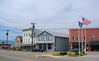
Elkton is an incorporated town in Rockingham County, Virginia, United States. It is included in the Harrisonburg Metropolitan Statistical Area. The population was 2,762 at the 2010 census. Elkton was named for the Elk Run stream.
Tomahawk is an unincorporated community that stretches along Kentucky Route 40 in Martin County, Kentucky, United States, in the eastern part of the state near the West Virginia border. It is located on Rockhouse Fork of Rockcastle Creek, approximately six miles (9.6 km) west of Inez, the county seat.

Winn is an unincorporated community and census-designated place (CDP) in Isabella County in the U.S. state of Michigan. The CDP had a population of 166 at the 2020 census. The community is located within Fremont Township.

Hardy is an unincorporated community in southwestern Bedford County and northeastern Franklin County, Virginia, United States. The community lies along State Route 634 and is approximately nine miles southeast of Roanoke.
Sugar Bush is an unincorporated community located entirely within the town of Maple Creek in northwest Outagamie County, Wisconsin, United States. Sugar Bush is classified as a Class U6 Community by the USGS, being a populated place located wholly or substantially outside the boundaries of any incorporated place or CDP with a recognized authoritative common name.
Wittensville is an unincorporated community in Johnson County, Kentucky, United States. Wittensville's ZIP code is 41274. It has a United States Postal Service, which stands besides a Dollar General which was constructed in June 2019. It also has an East Kentucky Realty estate agency.

Flintstone is an unincorporated community in Walker County, Georgia, United States. Located in northwestern Georgia, Flintstone lies approximately 12 miles south of Chattanooga, Tennessee, 120 miles northwest of Atlanta, 135 miles southeast of Nashville, Tennessee, and 150 miles northeast of Birmingham, Alabama. Although Flintstone is unincorporated, it has a post office, with the ZIP code of 30725; the ZCTA for ZIP Code 30725 had a population of 3,456 at the 2000 census.
Clifty, formerly called Lickskillet, is an unincorporated community in Todd County, Kentucky, United States.
Huff is an unincorporated community located in Edmonson County, Kentucky, United States.
Bent Mountain is an unincorporated community in Roanoke County, Virginia, United States. Bent Mountain is located on U.S. Route 221 13.6 miles (21.9 km) southwest of Roanoke. Bent Mountain has a post office with ZIP code 24059.

Belfry is an unincorporated community in Pike County, Kentucky. Belfry is located on U.S. Route 119, 16.8 miles (27.0 km) northeast of Pikeville. Belfry has a post office with ZIP code 41514, which opened on February 26, 1921. The origin of the name "Belfry" is obscure.

Huddleston is an unincorporated community in southeastern Bedford County, Virginia, United States. The community lies along State Route 626 and is located 12.5 miles (20.1 km) south-southeast of Bedford. It is part of the Lynchburg Metropolitan Statistical Area.
Villamont is an unincorporated community in western Bedford County, Virginia, United States. Villamont is located along U.S. Route 460 between Blue Ridge and Montvale. It is part of the Lynchburg Metropolitan Statistical Area.
Coleman Falls is an unincorporated community in northern Bedford County, Virginia, United States. The community is located along the James River and U.S. Route 501, between Big Island and Boonsboro. It is part of the Lynchburg Metropolitan Statistical Area.
Lowry is an unincorporated community in eastern Bedford County, Virginia, United States. The community is located along State Route 715 and is 5.2 miles (8.4 km) east-northeast of Bedford. It is part of the Lynchburg Metropolitan Statistical Area.
Rogers is an unincorporated community in Wolfe County, Kentucky. Rogers is on Kentucky Route 715 4.9 miles (7.9 km) west of Campton. Rogers has a post office with ZIP code 41365. Rogers Elementary School, a K-6 school in the Wolfe County Schools district, is located in Rogers.
Lime City is an unincorporated community in Wood County, Ohio, United States. It is part of Perrysburg Township and located at the intersection of Lime City Road and U.S. Route 20. Lacking a post office, Lime City's zip code falls within Perrysburg's 43551.
Roundhill is an unincorporated community in Butler County, Kentucky, United States, situated on Butler County's eastern boundary with Edmonson County.
Jetson is an unincorporated community in Butler County, Kentucky, United States.
Cromwell is an unincorporated community in Ohio County, Kentucky, United States.