Todd County is a county located in the U.S. state of Kentucky. As of the 2020 census, the population was 12,243. Its county seat is Elkton. The county is named for Colonel John Todd, who was killed at the Battle of Blue Licks in 1782 during the American Revolution.

Guthrie County is a county located in the U.S. state of Iowa. As of the 2020 census, the population was 10,623. The county seat is Guthrie Center. The county was formed on January 15, 1851, and named after Captain Edwin B. Guthrie, who died in the Mexican–American War.

New Providence is a small city in Hardin County, Iowa, United States. The population was 236 at the time of the 2020 census.
Fox Chase is a home rule-class city in Bullitt County, Kentucky, in the United States. It was formally incorporated by the state assembly in 1983. The population was 436 as of the 2020 census, down from 447 in the 2010 census.

Oak Grove is a home rule-class city adjacent to the Fort Campbell army base in Christian County, Kentucky, in the United States. The population was 7,931 as of the 2020 census, up from 7,489 as of the 2010 U.S. Census. It is part of the Clarksville, Tennessee metropolitan area.

Pembroke is a home rule-class city in Christian County, Kentucky, in the United States. The population was 865 as of the 2020 census, stagnant from 869 as of the 2010 U.S. Census. It is part of the Clarksville, Tennessee metropolitan area.

Ewing is a home rule-class city in Fleming County, Kentucky, in the United States. The population was 264 at the 2010 census.
Loyall is a home rule-class city in Harlan County, Kentucky, in the United States. The population was 1,461 as of the 2010 census, up from 766 at the time of the 2000 census.

White Plains is a home rule-class city in Hopkins County, Kentucky, United States. The population was 884 at the 2010 census, up from 800 at the 2000 census.
Bellewood is a home rule-class city in Jefferson County, Kentucky, United States. The city was formally incorporated by the state assembly in 1950. The population was 321 at the 2010 census.

Creekside is a home rule-class city in Jefferson County, Kentucky, United States. The population was 305 at the 2010 census.

Rolling Hills is a home rule-class city in Jefferson County, Kentucky. The population was 959 at the time of the 2010 census.

Spring Valley is a home rule-class city in Jefferson County, Kentucky, United States. Spring Valley Estates, begun in 1964, remained an unincorporated area until September, 1983. At that time, the City of Spring Valley was established to provide services. The current mayor is Gerri Willis. The population was 654 at the 2010 census. Population has increased to 837 based on the 2020 census.
Whipps Millgate is a former city in Jefferson County, Kentucky, United States. The population was 415 at the 2000 census. The City of Whipps Millgate was incorporated on April 26, 1969, it was dissolved and annexed by the City of Lyndon, Kentucky on July 1, 2001.
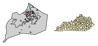
Fort Mitchell is a home rule-class city in Kenton County, Kentucky, United States. The population was 8,702 at the 2020 census. It is part of the Cincinnati metropolitan area.
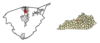
Elkton is a home rule-class city in and the county seat of Todd County, Kentucky, United States. The population was 2,062 at the 2010 census.

Waverly is a home rule-class city in Union County, Kentucky, United States. The population was 297 at the 2000 census. Founded in 1870, the city was named for founder Hugh McElroy's nephew.

Horace is a city in Cass County, North Dakota, United States. The population was 3,085 at the 2020 census.
Cherrytree Township is a township in Venango County, Pennsylvania, United States. The population was 1,306 at the 2020 census, a decrease from 1,973 in 2010. It is part of Titusville.

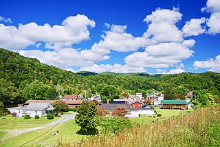
Dover is a city in and the county seat of Stewart County, Tennessee, 67 miles (108 km) west-northwest of Nashville on the Cumberland River. Fort Donelson National Cemetery is in Dover. The population was 1,442 at the 2000 census and the 2010 census showed a population of 1,417.