Todd County is a county located in the U.S. state of Kentucky. As of the 2020 census, the population was 12,243. Its county seat is Elkton. The county is named for Colonel John Todd, who was killed at the Battle of Blue Licks in 1782 during the American Revolution.
Fayette County is located in the central part of the U.S. state of Kentucky. As of the 2020 census, the population was 322,570, making it the second-most populous county in the commonwealth. Its territory, population and government are coextensive with the city of Lexington, which also serves as the county seat. Fayette County is part of the Lexington–Fayette, KY Metropolitan Statistical Area.

Richmond is a home rule-class city in and the county seat of Madison County, Kentucky, United States. It is named after Richmond, Virginia, and is home to Eastern Kentucky University. The population was 34,585 at the 2020 census. Richmond is the fourth-largest city in the Bluegrass region and the state's seventh-largest city. It is the ninth largest population center in the state with a Micropolitan population of 106,864. The city serves as the center for work and shopping for south-central Kentucky. In addition, Richmond is the principal city of the Richmond-Berea, Kentucky Micropolitan Area, which includes all of Madison and Rockcastle counties.
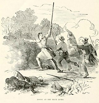
The Battle of Blue Licks, fought on August 19, 1782, was one of the last battles of the American Revolutionary War. The battle occurred ten months after Lord Cornwallis's surrender at Yorktown, which had effectively ended the war in the east. On a hill next to the Licking River in what is now Robertson County, Kentucky, a force of about 50 Loyalists along with 300 indigenous warriors ambushed and routed 182 Kentucky militiamen, who were partially led by Daniel Boone. It was the last victory for the Loyalists and natives during the frontier war. British, Loyalist and Native forces would engage in fighting with American forces once more the following month in Wheeling, West Virginia, during the Siege of Fort Henry.

The Red River, 100 miles (161 km) long, is a major stream of north-central Tennessee and south-central Kentucky, and a major tributary of the Cumberland River.

Virgie is a Census-designated place (CDP) located along Kentucky Route 1469 in Pike County, Kentucky, United States. Virgie's post office was established as Clintwood on April 3, 1890, with James M. Damron as postmaster. It was later renamed "Virgie" after the daughter of local resident, W.O.B. Ratliff, who was a lawyer and lumber dealer in Pikeville.
Clifty, formerly called Lickskillet, is an unincorporated community in Todd County, Kentucky, United States.
Tyewhoppety is an unincorporated community located in Todd County, Kentucky, United States. The community is located on Kentucky Route 181 14.5 miles (23.3 km) north of Elkton.
Pinchem is an unincorporated community in Clark County, Kentucky, United States.
Tiny Town is an unincorporated community located in Todd County, Kentucky, United States. It was also known as Breeze Inn and Grays Station.
Fairview is a small census-designated place on the boundary between Christian and Todd counties in the western part of the U.S. state of Kentucky. As of the 2010 census, it had a population of 286, with 186 living in Christian County and 100 living in Todd County. It is chiefly notable as the birthplace of Jefferson Davis, later President of the Confederate States of America, and as the location of the Jefferson Davis State Historic Site.

Several special routes of U.S. Route 68 exist from Kentucky to Ohio. In order from west to east in Kentucky, and south to north in Ohio, these special routes are listed from the beginning of U.S. Route 68 to the end.

Kentucky Route 104 is a 14.305-mile (23.022 km) state highway in Todd County, Kentucky that runs from Tennessee State Route 48 at the Kentucky-Tennessee state line northeast of Clarksville, Tennessee to Kentucky Route 181 just south of Elkton via Trenton.

Kentucky Route 181 (KY 181) is a north–south state highway that traverses two counties in western Kentucky.