Daysville | |
|---|---|
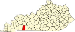
 Daysville Location within the state of Kentucky | |
| Coordinates: 36°48′8.15″N87°4′1.00″W / 36.8022639°N 87.0669444°W | |
| Country | United States |
| State | Kentucky |
| County | Todd |
| Elevation | 643 ft (196 m) |
| Time zone | UTC-6 (Central (CST)) |
| • Summer (DST) | UTC-5 (CST) |
| Area codes | 270 and 364 |
| GNIS feature ID | 490707 [1] |
Daysville is an unincorporated community in Todd County, Kentucky, United States. [1]