Logan County, Kentucky

Last updated

Logan County
Logan County courthouse Kentucky.JPG
Original Logan County courthouse in Russellville
Flag of Logan County, Kentucky.png
Seal of Logan County, Kentucky.png
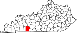
Map of Kentucky highlighting Logan County.svg
Location within the U.S. state of Kentucky
Kentucky in United States.svg
Kentucky's location within the U.S.
Coordinates: 36°52′N86°53′W / 36.86°N 86.88°W / 36.86; -86.88
CountryFlag of the United States.svg United States
StateFlag of Kentucky.svg  Kentucky
FoundedSeptember 1, 1792 (created)
Named for Benjamin Logan
Seat Russellville
Largest cityRussellville
Area
  Total557 sq mi (1,440 km2)
  Land552 sq mi (1,430 km2)
  Water4.9 sq mi (13 km2)  0.9%
Population
 (2020)
  Total27,432
  Estimate 
(2023)
28,283 Increase2.svg
  Density49/sq mi (19/km2)
Time zone UTC−6 (Central)
  Summer (DST) UTC−5 (CDT)
Congressional district 1st
Website logancountyky.gov

Logan County is a county in the southwest Pennyroyal Plateau area of Kentucky, United States. As of the 2020 census, the population was 27,432. [1] Its county seat is Russellville. [2]

Contents

History

The county is named for Benjamin Logan, who had been second in command of the Kentucky militia during the American Revolutionary War and was a leader in bringing statehood to the area. [3] [4] Created from Lincoln County on September 1, 1792, Logan was the 13th Kentucky county in order of formation. [5] Its original territory stretched from the Mississippi in the west to the Little Barren River in the east, and from the Green and Ohio Rivers in the north to the Tennessee border on the south; since then, 28 other counties have been formed within that area. [6] The settlement of Logan Court House was made the county seat at its incorporation under the name Russellville.

Future President Andrew Jackson fought a pistol duel against Charles Dickinson at Harrison's Mill in Logan County on May 30, 1806. Jackson was seriously wounded and Dickinson was killed. [6]

During the post-Reconstruction period, there was considerable racial violence by white mobs against black citizens in Logan County. Racist mobs lynched 12 African Americans in the county during the years between 1877 and 1908; most were killed around the turn of the 20th century. This is a higher total than in all but one other county in the state. [7] Four men were killed in a mass lynching on August 1, 1908, in Russellville, during the civil unrest associated with the Black Patch Tobacco Wars. Sharecroppers Joseph Riley, and Virgil, Robert, and Thomas Jones, [8] the last three members of the same family, were all hanged from the same cedar tree. They were the last persons lynched in Logan county. [9]

Logan was a major tobacco-growing county, with Dark Fired Tobacco produced by a special smoke processing. From 1906 some of its farmers became involved in the violent Black Patch Tobacco Wars, joining the Dark Tobacco District Planters' Protective Association of Kentucky and Tennessee to mobilize against the monopoly power of the American Tobacco Company, which had driven down prices to where farmers could barely make a living. Paramilitary Night Riders threatened other tobacco planters to "persuade" them to join the PPA. In late 1907 and early 1908, hundreds of Night Riders conducted raids against tobacco warehouses in some Kentucky towns. They struck Russellville on January 3, 1908, taking over the city and dynamiting two tobacco factories. [10]

21st century

In 2009, the Logan County/Russellville Little League Baseball team won the Little League World Series Great Lakes Regional Tournament as the 4th team from Kentucky to do so (as of 2017, Kentucky has had seven teams win the Great Lakes Tournament) to represent the Great Lakes Region in the Little League World Series. [11]

Geography

Logan County is on the south border of Kentucky; its south line abuts the north line of Tennessee. Its low hills are completely devoted to agriculture or urban development. [12] Its highest point (868 feet/265 meters ASL) is Rainbow Rock Knob WSW, located 3.6 miles (5.8 km) ESE from Russellville. [13] The Red River flows northwestward through the central and west part of the county, discharging into Todd County on the west. [12]

According to the United States Census Bureau, the county has a total area of 557 square miles (1,440 km2), of which 552 square miles (1,430 km2) is land and 4.9 square miles (13 km2) (0.9%) is water. [14]

Adjacent counties

Lakes

Demographics

Historical population
CensusPop.Note
1800 5,807
1810 12,123108.8%
1820 14,42319.0%
1830 13,012−9.8%
1840 13,6154.6%
1850 16,58121.8%
1860 19,02114.7%
1870 20,4297.4%
1880 24,35819.2%
1890 23,812−2.2%
1900 25,9949.2%
1910 24,977−3.9%
1920 23,633−5.4%
1930 21,875−7.4%
1940 23,3456.7%
1950 22,335−4.3%
1960 20,896−6.4%
1970 21,7934.3%
1980 24,13810.8%
1990 24,4161.2%
2000 26,5738.8%
2010 26,8351.0%
2020 27,4322.2%
2023 (est.)28,283 [15] 3.1%
U.S. Decennial Census [16]
1790–1960 [17] 1900–1990 [18]
1990–2000 [19] 2010–2020 [1]

2000 Census

As of the census of 2000, there were 26,573 people, 10,506 households, and 7,574 families in the county. The population density was 48 per square mile (19/km2). There were 11,875 housing units at an average density of 21 per square mile (8.1/km2). The racial makeup of the county was 90.70% White, 7.62% Black or African American, 0.21% Native American, 0.17% Asian, 0.01% Pacific Islander, 0.33% from other races, and 0.96% from two or more races. 1.08% of the population were Hispanic or Latino of any race.

There were 10,506 households, out of which 33.30% had children under the age of 18 living with them, 57.20% were married couples living together, 11.20% had a female householder with no husband present, and 27.90% were non-families. 25.00% of all households were made up of individuals, and 11.40% had someone living alone who was 65 years of age or older. The average household size was 2.50 and the average family size was 2.96.

The county population contained 25.70% under the age of 18, 8.40% from 18 to 24, 28.50% from 25 to 44, 23.60% from 45 to 64, and 13.80% who were 65 years of age or older. The median age was 37 years. For every 100 females there were 93.10 males. For every 100 females age 18 and over, there were 90.40 males.

The median income for a household in the county was $32,474, and the median income for a family was $39,307. Males had a median income of $29,750 versus $20,265 for females. The per capita income for the county was $15,962. About 10.80% of families and 15.50% of the population were below the poverty line, including 20.50% of those under age 18 and 18.60% of those age 65 or over.

Communities

Cities

Census-designated place

Unincorporated places

Attractions

Notable people

Politics

United States presidential election results for Logan County, Kentucky [24]
Year Republican Democratic Third party
No.%No.%No.%
2020 9,06773.42%3,09425.05%1891.53%
2016 7,77871.36%2,75525.28%3663.36%
2012 6,89965.64%3,46933.01%1421.35%
2008 6,92563.59%3,81135.00%1541.41%
2004 6,81564.03%3,76835.40%610.57%
2000 5,34457.27%3,88541.63%1031.10%
1996 3,88844.15%4,18147.47%7388.38%
1992 3,71041.93%4,06445.93%1,07512.15%
1988 4,29555.74%3,37943.85%310.40%
1984 4,88958.83%3,34740.28%740.89%
1980 3,36643.26%4,26454.80%1511.94%
1976 2,43032.89%4,85065.64%1091.48%
1972 3,57357.86%2,45939.82%1432.32%
1968 3,40239.16%3,33938.44%1,94622.40%
1964 2,23226.28%6,23473.39%280.33%
1960 4,11746.59%4,71953.41%00.00%
1956 2,85534.93%5,29964.83%200.24%
1952 2,75835.86%4,91763.94%150.20%
1948 1,35222.45%4,35572.31%3165.25%
1944 2,21130.13%5,11069.63%180.25%
1940 2,26825.46%6,63174.44%90.10%
1936 1,81226.86%4,91272.82%210.31%
1932 2,77828.01%7,07271.31%670.68%
1928 4,85855.79%3,84344.13%70.08%
1924 3,70542.80%4,77255.13%1792.07%
1920 3,94838.99%6,11160.36%660.65%
1916 2,50142.05%3,37356.71%741.24%
1912 1,63232.80%2,69754.21%64612.98%

See also

Related Research Articles

<span class="mw-page-title-main">Robertson County, Tennessee</span> County in Tennessee, United States

Robertson County is a county located on the central northern border of Tennessee in the United States. As of the 2020 United States Census, the population was 72,803 people. Its county seat is Springfield. The county was named for James Robertson, an explorer, founder of Nashville, and a state senator, who was often called the "Father of Middle Tennessee." Robertson County is a component of the Nashville-Davidson–Murfreesboro–Franklin, TN Metropolitan Statistical Area.

<span class="mw-page-title-main">Brown County, Ohio</span> County in Ohio, United States

Brown County is a county in the U.S. state of Ohio. As of the 2020 United States Census, the population was 43,676. The county seat and largest city is Georgetown. The county was created in 1818 and is named for Major General Jacob Brown, an officer in the War of 1812 who was wounded at the Battle of Lundy's Lane. Brown County is part of the Cincinnati-Middletown, OH-KY-IN Metropolitan Statistical Area.

<span class="mw-page-title-main">Warren County, Kentucky</span> County in Kentucky, United States

Warren County is a county located in the south central portion of the U.S. state of Kentucky. As of the 2020 census, the population was 134,554, making it the fifth-most populous county in Kentucky. The county seat is Bowling Green. Warren County is now classified as a wet county after voters approved the measure in 2018. The measure became law in January 2019 that allows alcohol to be sold county wide.

<span class="mw-page-title-main">Simpson County, Kentucky</span> County in Kentucky, United States

Simpson County is a county located in the south central portion of the U.S. state of Kentucky. As of the 2020 census, the total population was 19,594. Its county seat is Franklin.

<span class="mw-page-title-main">Mason County, Kentucky</span> County in Kentucky, United States

Mason County is a county located in the U.S. state of Kentucky. As of the 2020 census, the population was 17,120. Its county seat is Maysville. The county was created from Bourbon County, Virginia in 1788 and named for George Mason, a Virginia delegate to the U.S. Constitutional Convention known as the "Father of the Bill of Rights". Mason County comprises the Maysville, KY Micropolitan Statistical Area, which is included in the Cincinnati-Wilmington-Maysville, OH-KY-IN Combined Statistical Area.

<span class="mw-page-title-main">Hopkins County, Kentucky</span> County in Kentucky, United States

Hopkins County is a county located in the western part of the U.S. state of Kentucky. As of the 2020 census, the population was 45,423. Its county seat is Madisonville. Hopkins County was created December 9, 1806 from Henderson County. It was named for General Samuel Hopkins, an officer in both the American Revolutionary War and War of 1812, and later a Kentucky legislator and U.S. Congressman.

<span class="mw-page-title-main">Henderson County, Kentucky</span> County in Kentucky, United States

Henderson County is a county in the U.S. state of Kentucky. The county is located in western Kentucky on the Ohio River across from Evansville, Indiana. As of the 2020 census, the population was 44,793. Its county seat is Henderson.

<span class="mw-page-title-main">Grayson County, Kentucky</span> County in Kentucky, United States

Grayson County is a county located in the U.S. state of Kentucky. As of the 2020 census, the population was 26,420. Its county seat is Leitchfield. The county was formed in 1810 and named for William Grayson (1740–1790), a Revolutionary War colonel and a prominent Virginia political figure. Grayson County was formerly a prohibition or dry county, but Leitchfield allowed limited alcohol sales in restaurants in 2010 and voted "wet" in 2016.

<span class="mw-page-title-main">Graves County, Kentucky</span> County in Kentucky, United States

Graves County is a county located on the southwest border of the U.S. Commonwealth of Kentucky. As of the 2020 census, the population was 36,649. Its county seat is Mayfield. The county was formed in 1824 and was named for Major Benjamin Franklin Graves, a politician and fallen soldier in the War of 1812.

<span class="mw-page-title-main">Fulton County, Kentucky</span> County in Kentucky, United States

Fulton County is the westernmost county in the U.S. state of Kentucky, with the Mississippi River forming its western boundary. As of the 2020 census, the population was 6,515. Its county seat is Hickman and its largest city is Fulton. The county was formed in 1845 from Hickman County, Kentucky and named for Robert Fulton, the inventor of the steamboat.

<span class="mw-page-title-main">Caldwell County, Kentucky</span> County in Kentucky, United States

Caldwell County is a county located in the U.S. state of Kentucky. As of the 2020 census, the population was 12,649. Its county seat is Princeton. The county was formed in 1809 from Livingston County, Kentucky and named for John Caldwell, who participated in the George Rogers Clark Indian Campaign of 1786 and was the second lieutenant governor of Kentucky. Caldwell was a prohibition or dry county until 2013, when the citizens voted to lift the ban.

<span class="mw-page-title-main">Butler County, Kentucky</span> County in Kentucky, United States

Butler County is a county located in the US state of Kentucky. As of the 2020 Census, the population was 12,371. Its county seat is Morgantown. The county was formed in 1810, becoming Kentucky's 53rd county. Butler County is included in the Bowling Green, Kentucky, Metropolitan Statistical Area.

<span class="mw-page-title-main">Bracken County, Kentucky</span> County in Kentucky, United States

Bracken County is a county located in the U.S. state of Kentucky. As of the 2020 census, the population was 8,400. Its county seat is Brooksville. The county was formed in 1796. Bracken County is included in the Cincinnati-Middletown, OH-KY-IN Metropolitan Statistical Area.

<span class="mw-page-title-main">Allen County, Kentucky</span> County in Kentucky, United States

Allen County is a county located in the U.S. state of Kentucky. As of the 2020 census, the population was 20,588. Its county seat and only municipality is Scottsville. The county is named for Colonel John Allen, a state senator and soldier who was killed leading the 1st Regiment of Kentucky Rifleman at the Battle of Frenchtown, Michigan during the War of 1812. Allen County was a dry county until 2023, when it voted to legalize the sale of alcohol. It was formed in 1815 from parts of Barren and Warren counties. Allen County is included in the Bowling Green, KY Metropolitan Statistical Area.

<span class="mw-page-title-main">Lynch, Kentucky</span> City in Kentucky, United States

Lynch is a home rule-class city in Harlan County, Kentucky, United States. In the 2020 census the city population was 658, down from 747 in 2010.

<span class="mw-page-title-main">Grand Rivers, Kentucky</span> City in Kentucky, United States

Grand Rivers is a home rule-class city in Livingston County, Kentucky, in the United States. The population was 382 at the 2010 census, up from 343 in 2000. It is part of the Paducah, KY-IL Metropolitan Statistical Area.

<span class="mw-page-title-main">Adairville, Kentucky</span> City in Kentucky, United States

Adairville is a home rule-class city in Logan County, Kentucky, in the United States. Established on January 31, 1833, it was named for Governor John Adair and incorporated by the state assembly on February 7, 1871. The population was 852 at the 2010 census.

<span class="mw-page-title-main">Lewisburg, Kentucky</span> City in Kentucky, United States

Lewisburg is a home rule-class city in Logan County, Kentucky, in the United States. The population was 810 at the 2010 census, down from 903 at the 2000 census.

<span class="mw-page-title-main">Russellville, Kentucky</span> City in Kentucky, United States

Russellville is a home rule-class city in Logan County, Kentucky, in the United States. It is the seat of its county. The population was 6,960 at the time of the 2010 census.

<span class="mw-page-title-main">Allensville, Kentucky</span> Unincorporated community in Kentucky, United States

Allensville is a census-designated place and former city in Todd County, Kentucky, in the United States. The population was 189 at the 2000 census. Settled in the 19th century and formally incorporated in 1867, the city was named for a pioneer family in the area. The city government was officially dissolved in 2017 after years of inactivity.

References

  1. 1 2 "State & County QuickFacts". United States Census Bureau. Retrieved August 14, 2022.
  2. "Find a County". National Association of Counties. Retrieved June 7, 2011.
  3. The Register of the Kentucky State Historical Society, Vol. 1. Kentucky State Historical Society. 1903. p.  36.
  4. Collins, Lewis (1877). History of Kentucky. Library Reprints, Incorporated. p. 479. ISBN   9780722249208.
  5. Collins, Lewis (1882). Collins' Historical Sketches of Kentucky: History of Kentucky, Vol. 2. Collins & Company. p. 26.
  6. 1 2 Richardson, Evelyn B. Kentucky Encyclopedia, p. 568. "Logan County". University Press of Kentucky (Lexington), 1992. Accessed July 27, 2013.
  7. Lynching in America/ Supplement: Lynchings by County [ permanent dead link ], 3rd Ed. (2015) p. 5
  8. "Lynching in Russellville, Logan County, Kentucky", Photographic postcard, Oshkosh Public Museum
  9. George C. Wright, Racial Violence in Kentucky, 1865--1940: Lynchings, Mob Rule, and "Legal Lynchings", LSU Press (1996) pp. 124-125
  10. Griffin, Mark. Stand There and Tremble: When the Night Riders Came to Russellville . Pumpkin Bomb Press (2008)
  11. "Little League Baseball". www.littleleague.org. Archived from the original on June 11, 2010. Retrieved August 9, 2017.
  12. 1 2 3 Logan County KY (Google Maps, accessed August 29, 2020)
  13. Logan (Highest Point) (PeakBagger.com, accessed August 29, 2020)
  14. "2010 Census Gazetteer Files". US Census Bureau. August 22, 2012. Archived from the original on August 12, 2014. Retrieved August 17, 2014.
  15. "Annual Estimates of the Resident Population for Counties: April 1, 2020 to July 1, 2023". United States Census Bureau. Retrieved March 14, 2024.
  16. "U.S. Decennial Census". United States Census Bureau. Retrieved August 17, 2014.
  17. "Historical Census Browser". University of Virginia Library. Retrieved August 17, 2014.
  18. "Population of Counties by Decennial Census: 1900 to 1990". United States Census Bureau. Retrieved August 17, 2014.
  19. "Census 2000 PHC-T-4. Ranking Tables for Counties: 1990 and 2000" (PDF). United States Census Bureau. Archived (PDF) from the original on March 27, 2010. Retrieved August 17, 2014.
  20. Richelieu KY (Google Maps, accessed August 29, 2020)
  21. Richelieu (Auburn KY). Accessed August 29, 2020)
  22. Alex C. Finley. 1876, Reprint c. 2000. The History of Russellville and Logan County, Ky. Reprint: Russellville, Ky.: A. B. Willhite. 21–23, 25, 42 (numbering from reprint).
  23. Hardin, John A. (1995). "Green Pinckney Russell of Kentucky Normal and Industrial Institute for Colored Persons". Journal of Black Studies. 25 (5): 610–621. doi:10.1177/002193479502500506. ISSN   0021-9347. JSTOR   2784634. S2CID   143448048.
  24. Leip, David. "Atlas of US Presidential Elections". uselectionatlas.org. Retrieved July 4, 2018.

36°52′N86°53′W / 36.86°N 86.88°W / 36.86; -86.88