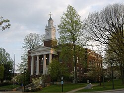
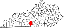
Barren County was established in 1798 from land taken from Green County and Warren County. Six courthouses have served the county throughout its history, the first built of logs.[7]
Barren County, like most of south-central Kentucky, was settled by the Scots-Irish, and still bears many cultural aspects that trace back to that heritage. The Scottish heritage is the most evident, as indicated, by the name of the county seat, which is named for Glasgow, Scotland, and is celebrated annually with the Glasgow Highland Games, one of three highland games held each year in Kentucky.
Barren was a prohibition or dry county, until voters overturned that in September 2016.[8] Prior to that, there were two exceptions:
Cave City, which voted in 2005 to become "moist" (selling only alcohol by the drink in restaurants of a certain minimum size (100 in this case) and which derive 70% or more of their revenue from food), and later voted in 2014 to approve full package sales.[9]
Glasgow, which approved liquor by the drink under the same restrictions on November 6, 2007,[10] after three previous elections to allow full alcohol sales in the city were soundly defeated.
Geography
According to the United States Census Bureau, the county has a total area of 500 square miles (1,300km2), of which 488 square miles (1,260km2) is land and 12 square miles (31km2) (2.5%) is water.[11]
Barren River Lake is located in the southern part of the county, forming part of its boundary with Allen County. Barren River Lake State Resort Park is located primarily within Barren County, along the lake's shoreline.
U.S. Decennial Census[13] 1790-1960[14] 1900-1990[15] 1990-2000[16] 2010-2020[1]
2020 census
As of the 2020 census, the county had a population of 44,485. The median age was 40.7 years. 24.0% of residents were under the age of 18 and 18.4% of residents were 65 years of age or older. For every 100 females there were 93.8 males, and for every 100 females age 18 and over there were 91.2 males age 18 and over.[17][18]
37.9% of residents lived in urban areas, while 62.1% lived in rural areas.[19]
There were 17,718 households in the county, of which 31.2% had children under the age of 18 living with them and 26.9% had a female householder with no spouse or partner present. About 27.4% of all households were made up of individuals and 12.7% had someone living alone who was 65 years of age or older.[17]
There were 19,794 housing units, of which 10.5% were vacant. Among occupied housing units, 65.3% were owner-occupied and 34.7% were renter-occupied. The homeowner vacancy rate was 1.9% and the rental vacancy rate was 8.6%.[17]
2000 census
As of the census[20] of 2000, there were 38,033 people, 15,346 households, and 10,941 families residing in the county. The population density was 78 per square mile (30/km2). There were 17,095 housing units at an average density of 35 per square mile (14/km2). The racial makeup of the county was 94.30% White, 4.09% Black or African American, 0.15% Native American, 0.41% Asian, 0.03% Pacific Islander, 0.38% from other races, and 0.65% from two or more races. 0.93% of the population were Hispanic or Latino of any race.
There were 15,346 households, out of which 31.70% had children under the age of 18 living with them, 58.30% were married couples living together, 9.80% had a female householder with no husband present, and 28.70% were non-families. 25.60% of all households were made up of individuals, and 11.60% had someone living alone who was 65 years of age or older. The average household size was 2.44 and the average family size was 2.91.
The age distribution was 24.20% under the age of 18, 8.20% from 18 to 24, 28.80% from 25 to 44, 23.80% from 45 to 64, and 15.00% who were 65 years of age or older. The median age was 38 years. For every 100 females, there were 92.70 males. For every 100 females age 18 and over, there were 89.30 males.
The median income for a household in the county was $31,240, and the median income for a family was $37,231. Males had a median income of $29,860 versus $21,208 for females. The per capita income for the county was $16,816. About 11.80% of families and 15.60% of the population were below the poverty line, including 20.30% of those under age 18 and 19.10% of those age 65 or over.
Barren County is primarily rural in nature, with agriculture as the primary industry. Glasgow, the county seat, has numerous manufacturing facilities, and is also a medical and retail hub for the area. Cave City is also a popular lodging area for tourists visiting nearby Mammoth Cave National Park.
Barren County's industry includes these companies:
Walmart of Glasgow - Walmart operates a full-service super center at the intersection of Kentucky Route 90 (Happy Valley Road) and Veterans Outer Loop on the northwest outskirts of the city.
Mid-State Recycling - the area's main recycling facility.
Glasgow Electric Plant Board - Electric, cable television, and internet service in the City of Glasgow.
Farmers Rural Electric Cooperative - Electric service for the county.
South Central Rural Telephone Cooperative - telephone, cable television and internet service.
T.J. Samson Community Hospital
Southern States Feed Mill in Park City
Dakota Elmore Realty and Auction Co.
In February 2026, Kingspan Group PLC, parent company of Tate, a data center infrastructure company announced a $76 million investment, first presented in October 2025, to open its largest North American manufacturing plant in Glasgow. The project is expected to create 400 new full-time manufacturing jobs once the 764,000-square-foot facility is fully operational. This is the largest job creation announcement in Barren County in nearly two decades.[22][23][24]
Politics
United States presidential election results for Barren County, Kentucky[25]
The Republican Party has the most registered voters. The county hasn't voted for the Democratic presidential candidate since 1992. 51% of the voters are registered to the Republican Party, and 40% are registered Democrats.
The county is home to all or part of three school districts:
Most of the county is served by the Barren County Schools, which includes Barren County High School and Middle School in Glasgow, and seven elementary schools throughout the county, many of which were formerly also high schools before they were consolidated into Barren County High in the early 1970s.[29]
The Glasgow Independent Schools serve the city of Glasgow proper, with small areas of overlap outside the city limits. The district includes Glasgow High School, Glasgow Middle School, and two elementary schools. In addition, the Glasgow and Caverna (see below) districts jointly operate an alternative school located in the Glasgow district for "at-risk" children in middle and high school. Barren County High and Middle Schools, although operated by the county district, are actually located within the boundaries of the Glasgow district.[30]
The Caverna Independent Schools take in Cave City and surrounding northwest Barren County, as well as Horse Cave and the southwest corner of neighboring Hart County. It is served by Caverna High School, Caverna Middle School, and Caverna Elementary School, all located between Cave City and Horse Cave. The high school is on the Hart County side of the line, while the elementary and middle schools share a campus on the Barren County side. The district is one of only a handful in the United States which is located in more than one county. Three other districts with this distinction are in Kentucky, most notably the Corbin Independent School District, serving a single city split by a county line.
Transportation
Barren County is served by Interstate 65, which goes through the northwest part of the county, and the Cumberland Expressway, a former toll road that was designated to be part of the future Interstate 66 corridor before that project was scrapped. U.S. Routes 31E, 31W, and 68 also pass through the county.
Railroad service is provided by CSX Transportation, whose former Louisville and Nashville Railroad main line passes through Cave City and Park City. The Glasgow Railway Company is a short line which owns a branch from Park City (which was formerly called Glasgow Junction) to Glasgow; the line is serviced via an operating lease by CSX.
Glasgow Transit operates deviated fixed-route bus service within Glasgow on weekdays.
Cave City's main industry in Barren County's economy is tourism, thanks to its proximity to Mammoth Cave National Park, which is one of the top ten most visited attractions in Kentucky. A number of motels and restaurants are located at the interchange of Interstate 65 and state routes 70 and 90, which cater to tourists visiting the area or just passing through, thereby making Cave City, and much of northwest Barren County, a tourism hot-spot. The city operates a small convention center that is popular with church groups and other family-related organizations, mainly because of the area's lack of crime and abundance of tourist attractions. Cave City has long been a gateway to Mammoth Cave; in the era of passenger rail travel, trains of the Louisville and Nashville Railroad would discharge tourists there, who would then be shuttled to the cave. The agricultural industry is also a big factor in the area's economy. For more information, see the Barren County Economic Authority's website (www.BarrenCoEa.com).
Events include, but are not limited to, the following:
The 400-mile yard sale along US 68 throughout the route's course in Kentucky (except Metro Lexington and the LBL) - first Thursday-Sunday in June, annually.[31]
Glasgow Highland Games at Barren River Lake State Resort Park - early June.
Annual Roller Coaster Yard Sale along State Highway 63 - early October.
Annual Fireworks Extravaganza at Barren River Lake, July 4 of each year.
Walter Arnold Baker (1937–2010): Associate Justice, Kentucky Supreme Court, Assistant General Counsel for International Affairs in the Department of Defense, Member of Kentucky Senate and House of Representatives, Lieutenant Colonel, Kentucky Air National Guard.
Ira F. M. Butler (1812–1909), Oregon pioneer and state legislator
Floyd Collins (1887–1925), cave explorer and cave accident victim
↑Dickerson, Brad; Neitzel, Stacy L. (November 7, 2007). "Liquor by the drink passes". Glasgow (KY) Daily Times. Archived from the original on September 11, 2012. Retrieved February 7, 2008.
↑"Glasgow Independent Schools map". Kentucky Department of Revenue. 1996. Archived from the original(PDF) on April 10, 2008. Retrieved February 7, 2008. As of 2008, Barren County High is still at the location indicated on the map (look in the southern part of the city, near the Cumberland Parkway). Although Barren County Middle is not listed on this map, it is located on the same street as the high school, as indicated at the official Barren County Schools website.
This page is based on this Wikipedia article Text is available under the CC BY-SA 4.0 license; additional terms may apply. Images, videos and audio are available under their respective licenses.

