Horse Cave, Kentucky

Last updated

Horse Cave, Kentucky
Davedowntwn8vl.jpg
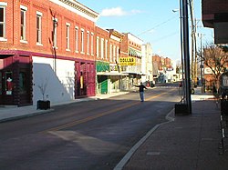
Downtown Horse Cave, December 2006, looking eastward down Main Street/HWY-218. The cave opening is to the right.
Hart County Kentucky Incorporated and Unincorporated areas Horse Cave Highlighted 2138008.svg
Location of Horse Cave in Hart County, Kentucky.
Coordinates: 37°10′34″N85°54′22″W / 37.17611°N 85.90611°W / 37.17611; -85.90611
Country United States
State Kentucky
County Hart
Area
[1]
  Total3.16 sq mi (8.20 km2)
  Land3.15 sq mi (8.15 km2)
  Water0.02 sq mi (0.05 km2)
Elevation
633 ft (193 m)
Population
 (2020)
  Total2,212
  Estimate 
(2022) [2]
2,246
  Density703.34/sq mi (271.52/km2)
Time zone UTC-6 (Central (CST))
  Summer (DST) UTC-5 (CDT)
ZIP code
42749
Area code(s) 270 & 364
FIPS code 21-38008
GNIS feature ID0494572
View from inside Hidden River Cave at the American Cave Museum Hidden River 6192.jpg
View from inside Hidden River Cave at the American Cave Museum

Horse Cave is a home rule-class city [3] in Hart County, Kentucky, United States. Randall Curry currently serves as mayor of the city and is assisted by a city council that is composed of six members. As of the 2010 census, the population of Horse Cave was 2,311, making it the most populous community in the county. [4]

Contents

History

The town was settled by Major Albert Anderson in the 1840s. The landowner donated land for a Louisville and Nashville Railroad station in 1858 on the provision that it be named after nearby Horse Cave. [5] The community around the station developed quickly, so that a post office was erected in 1860, [6] and the city was formally incorporated by the state assembly in 1864. [7]

The cave for which the city is named is located on the south side of Main Street. Various explanations are given for its unusual name. One is that Native Americans[ which? ] or outlaws hid horses in the cave; another is that an early carriage may have lost a horse when it fell into the opening by accident; a third reason involves the 19th-century use of "horse" as slang for anything big or huge, related to a similar use of the Swedish hoss. The cave has also been known as "Hidden River Cave", for an underground stream located inside. [6] That stream was used to power a dynamo, and for a while in the late 19th century Horse Cave was the only city in Kentucky apart from Louisville and Ashland to have electric lights.[ citation needed ] Around World War I, the only air-conditioned tennis courts in the world were located near the entrance of the cave.[ citation needed ] The stream also provided the town's water supply, but mistaken development caused raw sewage to seep into the water and forced the closure of the cave for fifty years. The stench was so bad in the 1960s that pedestrians typically crossed to the other side of Main Street rather than walk near the entrance and birds would sometimes fall from the sky. The problem has been largely solved in recent years.[ citation needed ]

The town changed its name to "Caverna" in 1869 but the inability to change the name of the railroad station prompted the community to reconsider and restore the name "Horse Cave" in 1879. [6] Owing to its early rail connection, Horse Cave was a major center of agricultural commerce for Hart, Metcalfe, Green, and Barren counties since the 1870s. Tobacco warehouses provided the majority of the income.

Since the 1970s, some factories have relocated to the area, including Dart Container Corporation, T Marzetti Company, and Sister Schubert's Bakery. Tourist attractions include Kentucky Down Under/Kentucky Caverns, Hidden River Cave/American Cave Museum, and the nearby Mammoth Cave National Park. Civil War Days are an annual tourist event, during which time parades down Main Street and reenactments of the Battle of Rowlett's Station between Horse Cave and Munfordville are staged. A local theatre formerly known as the Horse Cave Theatre and/or the Kentucky Repertory Theatre once operated in Horse Cave but is no longer in business. Horse Cave serves as filming location for several films, including "Runaway Romance" [8] and "Never Forgive." [9]

Artist Joseph Dudley Downing (1925-2007) was born and grew up in Horse Cave, where he graduated valedictorian of his class. In 1980, an exhibition of 150 of his paintings was held in the People's Loose Leaf Tobacco Warehouse No. 2. [10]

Geography

Horse Cave's southern border is the Barren County line and the border of Cave City. U.S. Route 31W (Dixie Street) is the main road through Horse Cave, leading north 8 miles (13 km) to Munfordville and southwest through Cave City 10 miles (16 km) to Park City near the entrance to Mammoth Cave National Park. Interstate 65 passes 2 miles (3 km) west of Horse Cave, with access from Exit 58. I-65 leads north 78 miles (126 km) to Louisville and southwest 97 miles (156 km) to Nashville, Tennessee.

According to the United States Census Bureau, the city of Horse Cave has a total area of 2.7 square miles (6.9 km2), of which 0.02 square miles (0.05 km2), or 0.74%, are water. [4]

Demographics

Historical population
CensusPop.Note
1870 479
1880 5269.8%
1890 59813.7%
1900 86745.0%
1910 8811.6%
1920 864−1.9%
1930 1,25945.7%
1940 1,2781.5%
1950 1,54520.9%
1960 1,78015.2%
1970 2,06816.2%
1980 2,045−1.1%
1990 2,28411.7%
2000 2,252−1.4%
2010 2,3112.6%
2020 2,212−4.3%
2022 (est.)2,246 [11] 1.5%
U.S. Decennial Census [12]

As of the census [13] of 2000, there were 2,252 people, 977 households, and 601 families residing in the city. The population density was 758.0 inhabitants per square mile (292.7/km2). There were 1,091 housing units at an average density of 367.2 per square mile (141.8/km2). The racial makeup of the city was 80.91% White, 17.94% Black or African American, 0.27% Native American, 0.04% from other races, and 0.84% from two or more races. 0.58% of the population were Hispanic or Latino of any race.

There were 977 households, out of which 28.0% had children under the age of 18 living with them, 40.2% were married couples living together, 18.2% had a female householder with no husband present, and 38.4% were non-families. 34.8% of all households were made up of individuals, and 16.8% had someone living alone who was 65 years of age or older. The average household size was 2.21 and the average family size was 2.84.

In the city, the population was spread out, with 21.8% under the age of 18, 8.8% from 18 to 24, 26.4% from 25 to 44, 22.6% from 45 to 64, and 20.3% who were 65 years of age or older. The median age was 40 years. For every 100 females, there were 81.8 males. For every 100 females age 18 and over, there were 72.5 males.

The median income for a household in the city was $21,134, and the median income for a family was $28,026. Males had a median income of $25,905 versus $18,457 for females. The per capita income for the city was $17,861. About 24.1% of families and 27.9% of the population were below the poverty line, including 36.8% of those under age 18 and 22.5% of those age 65 or over.

Arts and culture

Horse Cave has a library, the Horse Cave Public Library. [14]

Notable people

See also

Related Research Articles

<span class="mw-page-title-main">Hart County, Kentucky</span> County in Kentucky, United States

Hart County is a county located in the south central portion of the Commonwealth of Kentucky. As of the 2020 census, the population was 19,288. Its county seat is Munfordville, its largest city is Horse Cave. Hart County is a prohibition or dry county.

<span class="mw-page-title-main">Cave City, Kentucky</span> City in Kentucky, United States

Cave City is a home rule-class city in Barren County, Kentucky, in the United States. The population was 2,240 at the 2010 census. It is part of the Glasgow Micropolitan Statistical Area.

<span class="mw-page-title-main">Sonora, Kentucky</span> City in Kentucky, United States

Sonora is a home rule-class city in Hardin County, Kentucky, United States. The population was 513 at the 2010 census, up from 350 at the 2000 census. It is included in the Elizabethtown, Kentucky Metropolitan Statistical Area.

<span class="mw-page-title-main">Munfordville, Kentucky</span> City in Kentucky, United States

Munfordville is a home rule-class city in, and the county seat of, Hart County, Kentucky, United States. The population was 1,615 at the 2010 U.S. census.

<span class="mw-page-title-main">Bancroft, Kentucky</span> City in Kentucky, United States

Bancroft is a home rule-class city in Jefferson County, Kentucky, United States. It was formally incorporated by the state assembly in 1970. The population was 494 at the 2010 census.

<span class="mw-page-title-main">Bellemeade, Kentucky</span> City in Kentucky, United States

Bellemeade is a home rule-class city in Jefferson County, Kentucky, United States. It was formally incorporated by the state assembly in 1956. The population was 865 at the 2010 census.

<span class="mw-page-title-main">Briarwood, Kentucky</span> City in Kentucky, United States

Briarwood is a home rule-class city in Jefferson County, Kentucky, United States. The population was 435 at the 2010 census, down from 554 at the 2000 census.

<span class="mw-page-title-main">Cambridge, Kentucky</span> City in Kentucky, United States

Cambridge is a home rule-class city in Jefferson County, Kentucky, United States. The population was 175 at the 2010 census.

<span class="mw-page-title-main">Douglass Hills, Kentucky</span> City in Kentucky, United States

Douglass Hills is a home rule-class city in eastern Jefferson County, Kentucky, United States. The population was 5,484 at the 2010 census, down from 5,718 at the 2000 census.

<span class="mw-page-title-main">Glenview Manor, Kentucky</span> City in Kentucky, United States

Glenview Manor is a home rule-class city in Jefferson County, Kentucky, United States. The population was 191 at the 2010 census.

<span class="mw-page-title-main">Houston Acres, Kentucky</span> City in Kentucky, United States

Houston Acres is a home rule-class city in Jefferson County, Kentucky, United States. The population was 507 at the 2010 census.

<span class="mw-page-title-main">Lincolnshire, Kentucky</span> City in Kentucky, United States

Lincolnshire is a home rule-class city in Jefferson County, Kentucky, United States. The population was 148 at the 2010 census.

<span class="mw-page-title-main">Meadowbrook Farm, Kentucky</span> City in Kentucky, United States

Meadowbrook Farm is a neighborhood of Louisville, Kentucky, United States. It is separately incorporated as a home rule-class city. The population was 136 as of the 2010 census.

<span class="mw-page-title-main">Poplar Hills, Kentucky</span> City in Kentucky, United States

Poplar Hills is a home rule-class city in Jefferson County, Kentucky, United States. It is a part of the Louisville Metro government, but operates as a city under the Mayor to Commissioner form of government. Per the 2020 census, the population was 380, but the city administration has made several annexation ordinances that have passed and awaits updated information. The current city population is estimated to be 2380. It currently has the highest population density for any city in Kentucky.

<span class="mw-page-title-main">Spring Mill, Kentucky</span> City in Kentucky, United States

Spring Mill is a home rule-class city in Jefferson County, Kentucky, United States. The population was 287 at the 2010 census, down from 380 at the 2000 census.

<span class="mw-page-title-main">Thornhill, Kentucky</span> City in Kentucky, United States

Thornhill is a home rule-class city in Jefferson County, Kentucky, United States. The population was 178 at the 2010 census.

<span class="mw-page-title-main">Wellington, Kentucky</span> City in Kentucky, United States

Wellington is a home rule-class city in metro Louisville, Jefferson County, Kentucky, United States. It is considered to be part of the Upper Highlands section of Louisville. It was incorporated in 1946. The population was 565 at the 2010 census.

<span class="mw-page-title-main">West Buechel, Kentucky</span> City in Kentucky, United States

West Buechel is a home rule-class city in Jefferson County, Kentucky, United States. The population was 1,230 at the 2010 census, down from 1,301 at the 2000 census.

<span class="mw-page-title-main">Woodland Hills, Kentucky</span> City in Kentucky, United States

Woodland Hills is a home rule-class city in Jefferson County, Kentucky, United States. The population was 696 at the 2010 census.

<span class="mw-page-title-main">Worthington Hills, Kentucky</span> City in Kentucky, United States

City of Worthington Hills is a home rule-class city in Jefferson County, Kentucky, United States. The population was 1,446 at the 2010 census, down from 1,594 at the 2000 census.

References

  1. "2020 U.S. Gazetteer Files". United States Census Bureau. Retrieved March 18, 2022.
  2. "Annual Estimates of the Resident Population for Incorporated Places in Kentucky: April 1, 2020 to July 1, 2022". United States Census Bureau. Retrieved May 26, 2023.
  3. "Summary and Reference Guide to House Bill 331 City Classification Reform" (PDF). Kentucky League of Cities. Retrieved December 30, 2014.
  4. 1 2 "Geographic Identifiers: 2010 Demographic Profile Data (G001): Horse Cave city, Kentucky". American Factfinder. U.S. Census Bureau. Retrieved June 29, 2017.[ dead link ]
  5. The Kentucky Encyclopedia, pp. 442. "Horse Cave". University Press of Kentucky (Lexington), 1992. Accessed 30 July 2013.
  6. 1 2 3 Rennick, Robert M. (1987). Kentucky Place Names. University Press of Kentucky. pp. 144–145. ISBN   0813126312 . Retrieved April 28, 2013.
  7. Commonwealth of Kentucky. Office of the Secretary of State. Land Office. "Horse Cave, Kentucky". Accessed 29 July 2013.
  8. "'Runaway Romance' Filmed in Kentucky Airs Jan. 7".
  9. "Film shoot wraps in Horse Cave".
  10. "Horse Cave, KY, artist Joe Downing on ColumbiaMagazine.com". www.columbiamagazine.com. Retrieved April 13, 2023.
  11. "Annual Estimates of the Resident Population for Incorporated Places in Kentucky: April 1, 2020 to July 1, 2022". United States Census Bureau. Retrieved May 26, 2023.
  12. "Census of Population and Housing". Census.gov. Retrieved June 4, 2015.
  13. "U.S. Census website". United States Census Bureau . Retrieved January 31, 2008.
  14. "Kentucky Public Library Directory". Kentucky Department for Libraries and Archives. Archived from the original on January 11, 2019. Retrieved June 5, 2019.