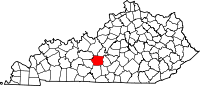
Hart County is a county located in the south central portion of the Commonwealth of Kentucky. As of the 2020 census, the population was 19,288. Its county seat is Munfordville, its largest city is Horse Cave. Hart County is a prohibition or dry county.

Kentucky Route 61 is a 151.333-mile (243.547 km) long Kentucky State Highway extending north from the Tennessee state line in Cumberland County to Columbia in Adair County through to Greensburg in Green County. From there, the route traverses LaRue, Hardin and Bullitt counties to terminate in Jefferson County at the junction of U.S. Route 31E in downtown Louisville.

State Road 166 in the U.S. State of Indiana is a short highway in southern Perry County. Though it has an even number, in practice it is a north–south highway for most of its length.

Kentucky Route 90 is a major east–west state highway in southern Kentucky. The route is 134.734 miles (216.833 km) long, and it traverses Barren, Metcalfe, Cumberland, Clinton, Wayne, Pulaski, McCreary and Whitley Counties in southern Kentucky. It runs from the KY 70 junction near Interstate 65 in Cave City to US 25W about 8 miles (13 km) from Interstate 75.

Kentucky Route 70 (KY 70) is a long east-east state highway that originates at a junction with U.S. Route 60 (US 60) in Smithland in Livingston County, just east of the Ohio River. The route continues through the counties of Crittenden, Caldwell, Hopkins, Muhlenberg, Butler, Edmonson, Barren, Barren, Metcalfe, Green, Taylor, Casey, Pulaski, Lincoln and back into Pulaski again to terminate at a junction with US 150 near Maretburg in Rockcastle.

Kentucky Route 185 is a north–south state highway traversing four counties in west-central Kentucky.
Woodlawn is an unincorporated community in Montgomery County, Tennessee.
Temple Hill is an unincorporated community in Barren County, Kentucky, in the United States.

Static is an unincorporated community in Clinton County, Kentucky, and Pickett County, Tennessee, in the southeastern United States. It is located on the Tennessee–Kentucky state line south of Albany, Kentucky, and north of Byrdstown, Tennessee.

Snow is an unincorporated community within Clinton County, Kentucky, United States.

Kentucky Route 106 (KY 106) is a 35-mile-long (56 km) east-west state highway traversing three counties in west-central Kentucky.

Kentucky Route 218 is a 31.113-mile-long (50.072 km) west-east state highway that traverses three counties in south-central Kentucky. It is locally known as LeGrande Highway from Horse Cave to near Shady Grove.
Veterans Outer Loop is a major bypass route in Glasgow, Kentucky. It is maintained by the Kentucky Transportation Cabinet (KYTC).
Roundhill is an unincorporated community in Butler County, Kentucky, United States, situated on Butler County's eastern boundary with Edmonson County.
Houchin's Ferry Road is a secondary roadway located in Edmonson County in west-central Kentucky. County road logs list this road as CR-1004 and CR-1005.
Jetson is an unincorporated community in Butler County, Kentucky, United States.

Beech Grove is an unincorporated community and census-designated place in McLean County, Kentucky, United States. Its population was 282 as of the 2020 census. Beech Grove has a post office with ZIP code 42322, which opened on April 29, 1878.
Griderville is a rural unincorporated community in northern Barren County, Kentucky, United States.
Highland Springs is a rural unincorporated community in northwest Barren County, Kentucky, United States.
Logansport is an unincorporated community in northwestern Butler County in south-central Kentucky, United States. Logansport is part of the Bowling Green Metropolitan Statistical Area.