A census-designated place (CDP) is a concentration of population defined by the United States Census Bureau for statistical purposes only.
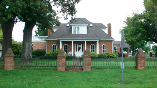
Farmington is an unincorporated community and census-designated place (CDP) in Graves County, Kentucky, United States. Farmington is located 8 miles (13 km) southeast of Mayfield, the Graves County seat, and 13 miles (21 km) west of Murray. The population of Farmington was 245 at the 2010 census.
The United States Census Bureau defines a place as a concentration of population which has a name, is locally recognized, and is not part of any other place. A place typically has a residential nucleus and a closely spaced street pattern, and it frequently includes commercial property and other urban land uses. A place may be an incorporated place or it may be a census-designated place (CDP). Incorporated places are defined by the laws of the states in which they are contained. The Census Bureau delineates CDPs. A small settlement in the open countryside or the densely settled fringe of a large city may not be a place as defined by the Census Bureau. As of the 1990 census, 26% of the people in the United States lived outside of places.
Cecilia is a census-designated place (CDP) and unincorporated community in Hardin County, Kentucky, United States. It is located 6 miles (10 km) west of Elizabethtown, the county seat. As of the 2020 Census, the population was 575, stagnant from the 2010 census population of 572.
Symsonia is an unincorporated community and census-designated place (CDP) in Graves County, Kentucky, United States. The community lies in the far northeastern part of the county, 13 miles (21 km) southeast of Paducah, 11 miles (18 km) northwest of Benton, and 15 miles (24 km) northeast of the county seat Mayfield, in the Jackson Purchase region of the state. As of the 2010 census, the population of Symsonia was 615.

Summersville is a census-designated place (CDP) and unincorporated community in Green County, Kentucky, United States. As of the 2010 census it had a population of 568.

Verona is an unincorporated community and census-designated place (CDP) in Boone County, Kentucky, United States. The population was 1,545 at the 2020 census.

Belleview is an unincorporated community and census-designated place (CDP) in Boone County, Kentucky, United States. The population was 308 as of the 2020 Census, down from 343 from the 2010 census.
Gracey is an unincorporated community and census-designated place in Christian County, Kentucky, United States. As of the 2020 census, the population was 117, down from 138 in the 2010 census.
Burna is an unincorporated community and census-designated place (CDP) in central Livingston County, Kentucky, United States. As of the 2010 census the population was 257. It is home to the North Livingston Elementary School and Livingston County Middle School.

Lowes is an unincorporated community and census-designated place (CDP) in Graves County, Kentucky, United States. Lowes is 13 miles (21 km) northwest of Mayfield. As of the 2010 Census the population of Lowes was 98.
Manitou is an unincorporated community and census-designated place (CDP) in Hopkins County, Kentucky, United States. As of the 2010 census the population was 181. It is a small community that lies a few miles northwest of Madisonville on US 41, at its intersection with KY 630 and KY 262.
Maceo is an unincorporated community and census-designated place (CDP) in Daviess County, Kentucky, United States. As of the 2020 census, the population was 404, down from the 2010 census population of 413.
Betsy Layne is a census-designated place (CDP) and coal town in Floyd County, Kentucky, United States. It was established in 1875 along the Levisa Fork. The post office opened on May 1, 1908, with Clayton S. Hitchins as postmaster. Its ZIP code is 41605. The 2010 census reported the population to be 688. Stage actress Bette Henritze was a native of Betsy Layne.
Sedalia is an unincorporated community and census-designated place (CDP) in Graves County, Kentucky, United States. As of the 2010 census the population was 295.
Pryorsburg is an unincorporated community and census-designated place (CDP) in Graves County, Kentucky, United States. As of the 2010 census the population was 311.
Artemus is an unincorporated community and census-designated place in Knox County, Kentucky, United States. As of the 2010 United States Census the population was 590.
Auxier is an unincorporated community and census-designated place (CDP) in Floyd County, Kentucky, United States. The 2010 United States Census reported that Auxier's population was 669, of which 661 persons were white and 2 persons were black.
Cawood is a census-designated place (CDP) and coal town in Harlan County, Kentucky, United States. The population was 731 at the 2010 census.
Flat Lick is an unincorporated community and census-designated place (CDP) in Knox County, Kentucky, United States. As of the 2010 census, the population was 960.