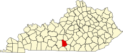
Metcalfe County | |
---|---|
Coordinates: 36°59′N85°38′W / 36.99°N 85.63°W | |
Country | United States |
State | Kentucky |
Founded | 1860 |
Named for | Thomas Metcalfe |
Seat | Edmonton |
Largest city | Edmonton |
Area | |
• Total | 291 sq mi (750 km2) |
• Land | 290 sq mi (800 km2) |
• Water | 1.5 sq mi (4 km2) 0.5% |
Population (2020) | |
• Total | 10,286 |
• Estimate (2023) | 10,482 |
• Density | 35/sq mi (14/km2) |
Time zone | UTC−6 (Central) |
• Summer (DST) | UTC−5 (CDT) |
Congressional district | 1st |
Website | www |
Metcalfe County is a county located in the U.S. state of Kentucky. Its county seat and only municipality is Edmonton. [1] The county was founded in May 1860 and named for Thomas Metcalfe, Governor of Kentucky from 1828 to 1832. [2] [3] Metcalfe County is part of the Glasgow, KY Micropolitan Statistical Area, which is also included in the Bowling Green-Glasgow, KY Combined Statistical Area.
According to the U.S. Census Bureau, the county has a total area of 291 square miles (750 km2), of which 290 square miles (750 km2) is land and 1.5 square miles (3.9 km2) (0.5%) is water. [4]
Census | Pop. | Note | %± |
---|---|---|---|
1870 | 7,934 | — | |
1880 | 9,423 | 18.8% | |
1890 | 9,871 | 4.8% | |
1900 | 9,988 | 1.2% | |
1910 | 10,453 | 4.7% | |
1920 | 10,075 | −3.6% | |
1930 | 9,373 | −7.0% | |
1940 | 10,853 | 15.8% | |
1950 | 9,851 | −9.2% | |
1960 | 8,367 | −15.1% | |
1970 | 8,177 | −2.3% | |
1980 | 9,484 | 16.0% | |
1990 | 8,963 | −5.5% | |
2000 | 10,037 | 12.0% | |
2010 | 10,099 | 0.6% | |
2020 | 10,286 | 1.9% | |
2023 (est.) | 10,482 | [5] | 1.9% |
U.S. Decennial Census [6] 1790–1960 [7] 1900–1990 [8] 1990–2000 [9] 2010–2021 [10] |
As of the census [11] of 2000, there were 10,037 people, 4,016 households, and 2,883 families residing in the county. The population density was 34 per square mile (13/km2). There were 4,592 housing units at an average density of 16 per square mile (6.2/km2). The racial makeup of the county was 97.26% White, 1.64% Black or African American, 0.25% Native American, 0.07% Asian, 0.13% from other races, and 0.65% from two or more races. 0.53% of the population were Hispanic or Latino of any race.
There were 4,016 households, out of which 32.30% had children under the age of 18 living with them, 58.10% were married couples living together, 10.00% had a female householder with no husband present, and 28.20% were non-families. 25.20% of all households were made up of individuals, and 12.30% had someone living alone who was 65 years of age or older. The average household size was 2.47 and the average family size was 2.93.
In the county, the population was spread out, with 24.60% under the age of 18, 8.20% from 18 to 24, 28.50% from 25 to 44, 23.60% from 45 to 64, and 15.00% who were 65 years of age or older. The median age was 38 years. For every 100 females, there were 95.20 males. For every 100 females age 18 and over, there were 92.60 males.
The median income for a household in the county was $23,540, and the median income for a family was $29,178. Males had a median income of $22,430 versus $18,591 for females. The per capita income for the county was $13,236. About 18.80% of families and 23.60% of the population were below the poverty line, including 29.20% of those under age 18 and 27.90% of those age 65 or over.
Year | Republican | Democratic | Third party | |||
---|---|---|---|---|---|---|
No. | % | No. | % | No. | % | |
2020 | 3,959 | 78.99% | 975 | 19.45% | 78 | 1.56% |
2016 | 3,491 | 75.56% | 976 | 21.13% | 153 | 3.31% |
2012 | 2,676 | 63.96% | 1,425 | 34.06% | 83 | 1.98% |
2008 | 2,734 | 65.11% | 1,350 | 32.15% | 115 | 2.74% |
2004 | 2,645 | 63.63% | 1,472 | 35.41% | 40 | 0.96% |
2000 | 2,476 | 64.33% | 1,318 | 34.24% | 55 | 1.43% |
1996 | 1,651 | 48.89% | 1,349 | 39.95% | 377 | 11.16% |
1992 | 1,683 | 44.14% | 1,703 | 44.66% | 427 | 11.20% |
1988 | 2,179 | 55.66% | 1,705 | 43.55% | 31 | 0.79% |
1984 | 2,349 | 59.56% | 1,575 | 39.93% | 20 | 0.51% |
1980 | 2,013 | 54.30% | 1,628 | 43.92% | 66 | 1.78% |
1976 | 1,356 | 41.52% | 1,877 | 57.47% | 33 | 1.01% |
1972 | 1,896 | 58.55% | 1,308 | 40.40% | 34 | 1.05% |
1968 | 1,566 | 51.41% | 1,001 | 32.86% | 479 | 15.73% |
1964 | 1,277 | 39.27% | 1,967 | 60.49% | 8 | 0.25% |
1960 | 2,146 | 58.02% | 1,553 | 41.98% | 0 | 0.00% |
1956 | 2,412 | 54.35% | 2,014 | 45.38% | 12 | 0.27% |
1952 | 2,176 | 53.90% | 1,848 | 45.78% | 13 | 0.32% |
1948 | 1,640 | 48.68% | 1,683 | 49.96% | 46 | 1.37% |
1944 | 2,306 | 57.48% | 1,694 | 42.22% | 12 | 0.30% |
1940 | 2,206 | 54.55% | 1,826 | 45.15% | 12 | 0.30% |
1936 | 1,777 | 50.34% | 1,748 | 49.52% | 5 | 0.14% |
1932 | 1,729 | 46.35% | 1,985 | 53.22% | 16 | 0.43% |
1928 | 2,314 | 66.92% | 1,144 | 33.08% | 0 | 0.00% |
1924 | 1,450 | 53.15% | 1,262 | 46.26% | 16 | 0.59% |
1920 | 1,809 | 55.51% | 1,442 | 44.25% | 8 | 0.25% |
1916 | 1,107 | 50.97% | 1,046 | 48.16% | 19 | 0.87% |
1912 | 482 | 23.89% | 887 | 43.95% | 649 | 32.16% |
Metcalfe County lies at the northwestern end of the Unionist bloc of counties that covered the eastern Pennyroyal and the Pottsville Escarpment of the Eastern Coalfield. Metcalfe itself was strongly Unionist during the Civil War, [13] and has been Republican for almost all the period since Reconstruction, though not to the same overwhelming extent as the counties to its east and south: Jimmy Carter even obtained 57 percent of the vote in 1976, and four other Democrats have narrowly carried the county since 1880 – although, as with all of rural Appalachia, the county has become overwhelmingly Republican in the twenty-first century due to views on environmental, social and cultural issues increasingly at odds with the national Democratic party. [14]
Taylor County is a county located in the U.S. state of Kentucky. As of the 2020 census, the population was 26,023. Its county seat is Campbellsville. Settled by people from Virginia, Pennsylvania, Maryland, and North Carolina after the American Revolutionary War, the county was organized in 1848 in the Highland Rim region. It is named for United States Army General Zachary Taylor, later President of the United States. Taylor County was the 100th of the 120 counties created by Kentucky. The Campbellsville Micropolitan Statistical Area includes all of Taylor County.
Spencer County is a county located in the U.S. state of Kentucky. As of the 2020 census, the total population was 19,490. Its county seat is Taylorsville. The county was founded in 1824 and named for Spier Spencer.
Simpson County is a county located in the south central portion of the U.S. state of Kentucky. As of the 2020 census, the total population was 19,594. Its county seat is Franklin.
Rockcastle County is a county located in the southeastern part of the U.S. state of Kentucky. As of the 2020 census, the population was 16,037. Its county seat is Mt. Vernon. The county was founded in 1810 and named for the Rockcastle River, which runs through it. The river, in turn, is named for its majestic rock cliffs. Rockcastle County is part of the Richmond-Berea, KY Micropolitan Statistical Area, which is also included in the Lexington-Fayette–Richmond–Frankfort, KY combined statistical area.
Nicholas County is a county located in the U.S. state of Kentucky. As of the 2020 census, the population was 7,537. Its county seat is Carlisle, which is also the only incorporated community in the county. Founded in 1799, the county is named for Col. George Nicholas, the "Father of the Kentucky Constitution."
Monroe County is a county located in the Eastern Pennyroyal Plateau region of the U.S. state of Kentucky. Its county seat is Tompkinsville. The county is named for President James Monroe. It was a prohibition or dry county until November 7, 2023, when voters approved the sale of alcohol.
Meade County is a county located in the U.S. state of Kentucky. As of the 2020 census, the population was 30,003. Its county seat is Brandenburg. The county was founded December 17, 1823, and named for Captain James M. Meade, who was killed in action at the Battle of River Raisin during the War of 1812. Meade County is part of the Elizabethtown-Fort Knox, KY Metropolitan Statistical Area, which is included in the Louisville/Jefferson County-Elizabethtown-Madison, KY-IN Combined Statistical Area.
Mason County is a county located in the U.S. state of Kentucky. As of the 2020 census, the population was 17,120. Its county seat is Maysville. The county was created from Bourbon County, Virginia in 1788 and named for George Mason, a Virginia delegate to the U.S. Constitutional Convention known as the "Father of the Bill of Rights". Mason County comprises the Maysville, KY Micropolitan Statistical Area, which is included in the Cincinnati-Wilmington-Maysville, OH-KY-IN Combined Statistical Area.
Marion County is a county in the U.S. state of Kentucky. As of the 2020 census, the total population was 19,581. Its county seat is Lebanon. The county was founded in 1834 and named for Francis Marion, the American Revolutionary War hero known as the "Swamp Fox".
Livingston County is a county located in the U.S. state of Kentucky. As of the 2020 census, the population was 8,888. Its county seat is Smithland and its largest community is Ledbetter. The county was established in 1798 from land taken from Christian County and is named for Robert R. Livingston, a member of the Committee of Five that drafted the U.S. Declaration of Independence. The county was strongly pro-Confederate during the American Civil War and many men volunteered for the Confederate Army. Livingston County is part of the Paducah, KY-IL Metropolitan Statistical Area. It is a prohibition or dry county with the exception of Grand Rivers which voted to allow alcohol sales in 2016.
Lincoln County is a county located in south-central Kentucky. As of the 2020 census, the population was 24,275. Its county seat is Stanford. Lincoln County is part of the Danville, KY Micropolitan Statistical Area.
Henry County is a county located in the north central portion of the U.S. state of Kentucky bordering the Kentucky River. As of the 2020 census, the population was 15,678. Its county seat is New Castle, but its largest city is Eminence. The county was founded in 1798 from portions of Shelby County. It was named for the statesman and governor of Virginia Patrick Henry. Henry County is included in the Louisville/Jefferson County, KY-IN Metropolitan Statistical Area. Since the 1990s, it has become an increasingly important exurb, especially as land prices have become higher in neighboring Oldham County. With regard to the sale of alcohol, it is classified as a wet county.
Harrison County is a county located in the U.S. state of Kentucky. As of the 2020 census, the population was 18,692. Its county seat is Cynthiana. The county was founded in 1793 and named for Colonel Benjamin Harrison, an advocate for Kentucky statehood, framer of the Kentucky Constitution, and Kentucky legislator.
Hancock County is a county located in the U.S. state of Kentucky. As of the 2020 census, the population was 9,095. Its county seat is in the city of Hawesville located in the Northern part of the county, and its largest city of Lewisport is located in the Northwestern part of the county.
Cumberland County is a county located in the Pennyroyal Plateau region of the U.S. state of Kentucky. As of the 2020 census, the population was 5,888. Its county seat is Burkesville. The county was formed in 1798 and named for the Cumberland River, which in turn may have been named after the Duke of Cumberland or the English county of Cumberland.
Casey County is a county located in the U.S. Commonwealth of Kentucky. As of the 2020 census, the population was 15,941. Its county seat is Liberty. The county was formed in 1806 from the western part of Lincoln County and named for Colonel William Casey, a pioneer settler who moved his family to Kentucky in 1779. It is the only Kentucky county entirely in the Knobs region. Casey County is home to annual Casey County Apple Festival, and is a prohibition or dry county. It is considered part of the Appalachian region of Kentucky.
Carlisle County is a county located in the U.S. state of Kentucky. As of the 2020 census, the population was 4,826, making it the fourth-least populous county in Kentucky. Its county seat is Bardwell. The county was founded in 1886 and named for John Griffin Carlisle, a Speaker of the United States House of Representatives from Kentucky. It remains a prohibition or dry county. Carlisle County is included in the Paducah, KY-IL, Metropolitan Statistical Area.
Edmonton is a home rule-class city in and the county seat of Metcalfe County, Kentucky, United States. It is part of the Glasgow Micropolitan Statistical Area. The population was 1,671 at the 2020 census.
Tompkinsville is a home rule-class city in and the county seat of Monroe County, Kentucky, United States. The population was 2,309 at the 2020 census. The city was named after Vice President Daniel D. Tompkins who served under President James Monroe, for whom the county was named.
Knox County is a county located in Appalachia near the southeastern corner of the U.S. state of Kentucky. As of the 2020 census, the population was 30,193. Its county seat is Barbourville. The county is named for General Henry Knox. It is one of the few coal-producing counties in Kentucky that has not suffered massive population loss. Knox County is included in the London, KY Micropolitan Statistical Area.
{{cite web}}
: |last3=
has generic name (help)CS1 maint: multiple names: authors list (link)