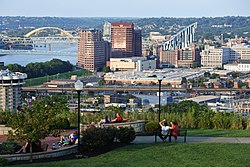
Covington, Kentucky

Last updated

Covington, Kentucky
Covington, Kentucky.jpg
Downtown Covington skyline
Seal of Covington, Kentucky.png
Kenton County Kentucky Incorporated and Unincorporated areas Covington Highlighted 2117848.svg
Location of Covington in Kenton County, Kentucky.
USA Kentucky relief location map.svg
Red pog.svg
Covington
Usa edcp relief location map.png
Red pog.svg
Covington
Coordinates: 39°02′00″N84°31′00″W / 39.03333°N 84.51667°W / 39.03333; -84.51667 [1]
Country United States
State Kentucky
County Kenton
Founded1815
Government
  TypeCommission-City Manager
   Mayor Joseph U. Meyer (D) [2]
Area
[3]
  Total13.76 sq mi (35.63 km2)
  Land13.20 sq mi (34.18 km2)
  Water0.56 sq mi (1.45 km2)
Elevation
[1]
719 ft (219 m)
Population
 (2020)
  Total40,961
  Estimate 
(2022) [4]
40,956
  Density3,103.81/sq mi (1,198.42/km2)
Time zone UTC−5 (EST)
  Summer (DST) UTC−4 (EDT)
ZIP code
41011-41012, 41014-41019
Area code 859
FIPS code 21-17848
GNIS feature ID2404138 [1]
Website covingtonky.gov

Covington is a home rule-class city in Kenton County, Kentucky, United States. Located at the confluence of the Ohio and Licking rivers, it lies south of Cincinnati, Ohio, across the Ohio and west of Newport, Kentucky, across the Licking. It had a population of 40,691 at the 2020 census, making it the largest city in Northern Kentucky and the fifth-most populous city in the state. [5] A part of the Cincinnati metropolitan area, it is one of Kenton County's two seats, along with Independence. [6]

Contents

History

The former union station in 2018 Covington station 2018.jpg
The former union station in 2018

In 1814, John Gano, Richard Gano, and Thomas Carneal purchased The Point, 150 acres (0.6 km2) of land on the west side of the Licking River at its confluence with the Ohio, from Thomas Kennedy for $50,000, and laid out the settlement of Covington the next year. [7] It was named in honor of Gen. Leonard Covington, [8] who was killed at the Battle of Crysler's Farm during the War of 1812. [9] The town was formally incorporated by the Kentucky General Assembly a year later[ citation needed ] and raised to city status in 1834. [9]

The city prospered as an emporium for Kentucky's tobacco and cigar production. [10] In 1862, Stewart Iron Works was established; for a time, it was the largest iron fence maker in the world and still exists today as part of the Huseman Group of Cincinnati. There were also distilleries, glassworks, and stove factories. [10] Like nearby Cincinnati, Covington's factories and businesses were particularly staffed by Catholic and German immigrants. [10] Its Catholic church was eventually raised to the level of a diocese. [9]

In 1880, the city was named the center of the country's population by the U.S. Census Bureau. [11]

By 1900, Covington was the second-largest city and industrial region in Kentucky. [9] At the time, its population of almost 43,000 was about 12% foreign-born and 5% Black. [9] By this time, it was connected to the Chesapeake & Ohio and Louisville & Nashville railways, and companies offered steamboat service to other ports on the Ohio River. [9] Its factories had expanded to include cotton goods, machinery, and cordage. [9]

Covington even boasted a Federal League baseball team, the Covington Blue Sox, during the 1913 season. The present-day circuit courthouse is located at the site of its former grounds, Federal Park, which is thought to have been the smallest stadium ever used by a professional baseball club.

It declined in importance during the Great Depression and the middle 20th century. [7] The city has undergone some redevelopment during the late 20th and early 21st centuries as the most populous city in Kenton County.

Geography

A view of the John A. Roebling Suspension Bridge, looking south across the Ohio River toward Covington JohnARoeblingSuspensionBridge.jpg
A view of the John A. Roebling Suspension Bridge, looking south across the Ohio River toward Covington

The city is on the south bank of the Ohio River with Cincinnati, Ohio across the river to the north. The Licking River forms the eastern boundary with Newport in the adjacent Campbell County. [12]

According to the United States Census Bureau, Covington has a total area of 13.7 square miles (35 km2), of which 13.1 square miles (34 km2) is land and 0.5 square miles (1.3 km2) (3.88%) is covered by water.

Neighborhoods

Covington claims 19 distinct neighborhoods, [13] ranging in population from several hundred to 10,000 people. Many of the neighborhoods are located in 12 historic districts that are predominantly found in the northern portion of the city, but Covington annexed many areas to the south in the late 20th and early 21st centuries to significantly enlarge its land area. Most of the neighborhoods have active resident associations or block watches that are dedicated to involving residents in strengthening their neighborhoods, improving safety, housing, and beautification.

Climate

Covington is located within a climatic transition zone; it is nestled within the southern end of the humid continental climate zone and the northern periphery of the humid subtropical climate of the Upland South, with hot, humid summers and cool winters. Evidence of both a humid subtropical and humid continental climate can be found here, particularly noticeable by the presence of plants indicative of each climatic region; for example, the southern magnolia (Magnolia grandiflora) from the subtropics and the blue spruce from cooler regions are successful landscape plants in and around Covington.

Climate data for Cincinnati (Cincinnati/Northern Kentucky Int'l), 1991–2020 normals, [lower-alpha 1] extremes 1871–present [lower-alpha 2]
MonthJanFebMarAprMayJunJulAugSepOctNovDecYear
Record high °F (°C)77
(25)
79
(26)
88
(31)
90
(32)
95
(35)
102
(39)
108
(42)
103
(39)
102
(39)
95
(35)
82
(28)
75
(24)
108
(42)
Mean maximum °F (°C)61.8
(16.6)
66.1
(18.9)
74.3
(23.5)
81.1
(27.3)
86.7
(30.4)
91.6
(33.1)
93.6
(34.2)
93.2
(34.0)
90.7
(32.6)
82.9
(28.3)
72.0
(22.2)
63.8
(17.7)
95.3
(35.2)
Mean daily maximum °F (°C)39.6
(4.2)
43.7
(6.5)
53.5
(11.9)
65.5
(18.6)
74.5
(23.6)
82.6
(28.1)
86.0
(30.0)
85.2
(29.6)
78.9
(26.1)
66.7
(19.3)
53.8
(12.1)
43.3
(6.3)
64.4
(18.0)
Daily mean °F (°C)31.4
(−0.3)
34.7
(1.5)
43.6
(6.4)
54.6
(12.6)
64.1
(17.8)
72.3
(22.4)
75.9
(24.4)
74.9
(23.8)
68.1
(20.1)
56.2
(13.4)
44.4
(6.9)
35.6
(2.0)
54.7
(12.6)
Mean daily minimum °F (°C)23.1
(−4.9)
25.8
(−3.4)
33.8
(1.0)
43.7
(6.5)
53.7
(12.1)
62.1
(16.7)
65.9
(18.8)
64.6
(18.1)
57.3
(14.1)
45.7
(7.6)
35.1
(1.7)
27.9
(−2.3)
44.9
(7.2)
Mean minimum °F (°C)0.1
(−17.7)
6.5
(−14.2)
14.8
(−9.6)
26.7
(−2.9)
36.6
(2.6)
49.2
(9.6)
55.9
(13.3)
54.6
(12.6)
42.5
(5.8)
29.8
(−1.2)
19.0
(−7.2)
9.1
(−12.7)
−2.7
(−19.3)
Record low °F (°C)−25
(−32)
−17
(−27)
−11
(−24)
15
(−9)
27
(−3)
39
(4)
47
(8)
43
(6)
31
(−1)
16
(−9)
0
(−18)
−20
(−29)
−25
(−32)
Average precipitation inches (mm)3.30
(84)
3.17
(81)
4.16
(106)
4.53
(115)
4.67
(119)
4.75
(121)
3.83
(97)
3.43
(87)
3.11
(79)
3.35
(85)
3.23
(82)
3.73
(95)
45.26
(1,150)
Average snowfall inches (cm)7.7
(20)
6.7
(17)
3.4
(8.6)
0.4
(1.0)
0.0
(0.0)
0.0
(0.0)
0.0
(0.0)
0.0
(0.0)
0.0
(0.0)
0.2
(0.51)
0.8
(2.0)
4.1
(10)
23.3
(59)
Average precipitation days (≥ 0.01 in)13.212.012.513.113.511.811.08.98.38.710.312.4135.7
Average snowy days (≥ 0.1 in)6.75.92.70.60.00.00.00.00.00.11.14.621.7
Average relative humidity (%)72.270.167.062.866.969.271.572.372.769.271.073.869.9
Average dew point °F (°C)19.9
(−6.7)
22.5
(−5.3)
31.3
(−0.4)
39.6
(4.2)
50.5
(10.3)
59.7
(15.4)
64.2
(17.9)
63.0
(17.2)
56.7
(13.7)
43.7
(6.5)
34.7
(1.5)
25.5
(−3.6)
42.6
(5.9)
Mean monthly sunshine hours 120.8128.4170.1211.0249.9275.5277.0261.5234.4188.8118.799.32,335.4
Percent possible sunshine 40434653566261626355393452
Average ultraviolet index 2356899874225
Source 1: NOAA (relative humidity and sun 1961–1990) [14] [15] [16] [17]
Source 2: Weather Atlas (UV) [18]

Demographics

The Ascent at Roebling's Bridge AscentAtRB.jpg
The Ascent at Roebling's Bridge
Historical population
CensusPop.Note
1830 743
1840 2,026172.7%
1850 9,408364.4%
1860 16,47175.1%
1870 24,50548.8%
1880 29,72021.3%
1890 37,37125.7%
1900 42,93814.9%
1910 53,27024.1%
1920 57,1217.2%
1930 65,25214.2%
1940 62,018−5.0%
1950 64,4523.9%
1960 60,376−6.3%
1970 52,535−13.0%
1980 49,585−5.6%
1990 43,264−12.7%
2000 43,3700.2%
2010 40,640−6.3%
2020 40,9610.8%
2022 (est.)40,956 [19] 0.0%
U.S. Decennial Census [20]

2020 census

As of the census of 2020, there were 40,691 people living in the city, for a population density of 3,103.81 people per square mile (1,198.42/km2). There were 20,576 housing units. The racial makeup of the city was 75.7% White, 11.6% Black or African American, 0.5% Native American, 0.6% Asian, 0.1% Pacific Islander, 3.7% from some other race, and 7.8% from two or more races. 7.0% of the population were Hispanic or Latino of any race. [21]

There were 18,040 households, out of which 25.1% had children under the age of 18 living with them, 29.1% were married couples living together, 26.9% had a male householder with no spouse present, and 32.9% had a female householder with no spouse present. 38.3% of all households were made up of individuals, and 10.8% were someone living alone who was 65 years of age or older. The average household size was 2.21, and the average family size was 2.99. [21]

21.6% of the city's population were under the age of 18, 65.0% were 18 to 64, and 13.4% were 65 years of age or older. The median age was 36.9. For every 100 females, there were 104.9 males. [21]

According to the U.S. Census American Community Survey, for the period 2016-2020 the estimated median annual income for a household in the city was $47,917, and the median income for a family was $60,224. About 23.9% of the population were living below the poverty line, including 37.9% of those under age 18 and 14.6% of those age 65 or over. About 61.8% of the population were employed. [21]

2000 census

As of the census [22] of 2000, 43,370 people, 18,257 households, and 10,132 families resided in the city. The population density was 3,301.3 inhabitants per square mile (1,274.6/km2). The 20,448 housing units averaged 1,556.5 per square mile (600.8/km2). The racial makeup of the city was 87.05% White, 10.14% African American, 0.24% Native American, 0.34% Asian, 0.03% Pacific Islander, 0.63% from other races, and 1.57% from two or more races. Hispanics or Latinos of any race were 1.38% of the population.

Of the 18,257 households, 28.8% had children under the age of 18 living with them, 34.3% were married couples living together, 16.5% had a female householder with no husband present, and 44.5% were not families; 36.5% of all households were made up of individuals, and 12.0% had someone living alone who was 65 years of age or older. The average household size was 2.31 and the average family size was 3.08.

The age distribution was 25.9% under the age of 18, 10.0% from 18 to 24, 33.3% from 25 to 44, 19.0% from 45 to 64, and 11.9% who were 65 years of age or older. The median age was 33 years. For every 100 females, there were 95.9 males. For every 100 females age 18 and over, there were 92.0 males.

The median income for a household in the city was $30,735, and the median income for a family was $38,307. Males had a median income of $31,238 versus $24,487 for females. The per capita income for the city was $16,841. About 15.5% of families and 18.4% of the population were below the poverty line, including 25.0% of those under age 18 and 13.4% of those age 65 or over.

Covington has some of the least expensive real estate in Kentucky; the median house price in Covington is around $95,430, while the median house price for Kentucky as a whole is $124,100. [23]

Arts and culture

Historic churches

Cathedral Basilica of the Assumption, Roman Catholic Diocese of Covington St. Mary - Covington 01.jpg
Cathedral Basilica of the Assumption, Roman Catholic Diocese of Covington

Economy

Downtown Covington skyline as viewed from Cincinnati. Covington ky downtown skyline.jpg
Downtown Covington skyline as viewed from Cincinnati.

According to Covington's 2019 Comprehensive Annual Financial Report, [24] the principal employers in the city are:

#Employer# of Employees
1 Internal Revenue Service - partially closed in 20193,951
2 Fidelity Investments 2,069
3Club Chef1,039
4 Covington Board of Education 914
5Crown Services Inc.524
6Rosedale Manor488
7 State of Kentucky 477
8St. Elizabeth Hospital408
9 Diocese of Covington Board of Education403
10Atkins & Pearce Mftg339

Education

Public education within much of Covington is provided by Covington Independent Public Schools, the largest independent school district in Kentucky. [25] Its high school, Holmes Junior/Senior High School, is the oldest public high school in the state.

Southern portions of the city are in the Kenton County School District. [26]

The Roman Catholic Diocese of Covington operates two high schools in the city, Covington Latin School and Holy Cross High School. Two Catholic high schools, the all-boys' Covington Catholic High School and all-girls' Notre Dame Academy, moved to neighboring Park Hills in the 1950s. Calvary Christian School, a Baptist school, is also located in Covington.

Infrastructure

Transportation

Delta (Comair) Planes at CVG Concourse C EM C-GATES-CVG (2726391021).jpg
Delta (Comair) Planes at CVG Concourse C

U.S. Route 25, Interstate 71 and Interstate 75 serve downtown Covington.

Bus transit is served by the Transit Authority of Northern Kentucky (TANK). [27]

Covington Union Station served Chesapeake and Ohio and Louisville and Nashville passenger trains into the 1960s. The final train making stops at the station was the L&N's Pan-American (Cincinnati-New Orleans) in 1971. The L&N's Humming Bird (Cincinnati- Memphis and New Orleans) also served the station. C&O trains included the Fast Flying Virginian, George Washington and Sportsman. The C&O dropped Union Station from its trains' itineraries in 1966.

Covington is served by Cincinnati/Northern Kentucky International Airport (CVG), which is the largest airport in the state. The airport is one of DHL Aviation's three superhubs, serving destinations throughout the Americas, Europe, Africa, and Asia, making it the seventh-busiest airport in the U.S. based on cargo operations. [28] CVG also serves as a focus city for Allegiant Air and is the airlines largest O&D airport. The airport additionally serves as an operating base for Delta Air Lines subsidiary Endeavor Air and as a maintenance base for American Airlines subsidiary PSA Airlines.

Law enforcement

In 1817, the Town of Covington created the position "Captain of Patrol," and assigned two "Patrollers" under his supervision. The patrol area included the Town and eight miles of surrounding territory. In 1833 the first full time Town Marshall was appointed. An act of the Kentucky General Assembly in 1834 incorporated Covington as a city, and in 1842, the City of Covington appointed its first "Police Commissioner." Covington City Ordinance created the “Voluntary Night Watch" in 1843, which consisted of seventy-one reputable persons invested with police authority. In 1856 a regular citizen's police force was established. [29] The department is staffed by 114 sworn officers, each assigned to one of 4 bureaus. There are substations, and a central headquarters. [30] The department maintains accreditation through the Kentucky Association of Chiefs of Police as well as the Commission on Accreditation for Law Enforcement Agencies. [31]

Fire protection

The Covington Fire Department was created on June 30, 1864. [32] Since 1918, the Covington Fire Department has been represented by Covington Professional Firefighters Local 38, a member union of the International Association of Firefighters. Covington FD was a charter member of the IAFF. [33]

Notable people

See also

Related Research Articles

<span class="mw-page-title-main">Pendleton County, Kentucky</span> County in Kentucky, United States

Pendleton County is a county located in the U.S. state of Kentucky. As of the 2020 census, the population was 14,644. Its county seat is Falmouth. The county was founded December 13, 1798. Pendleton County is included in the Cincinnati-Middletown, OH-KY-IN Metropolitan Statistical Area.

<span class="mw-page-title-main">Kenton County, Kentucky</span> County in Kentucky, United States

Kenton County is a county located in the northern part of the Commonwealth of Kentucky. As of the 2020 census, the population was 169,064, making it the third most populous county in Kentucky. Its county seats are Covington and Independence. It was, until November 24, 2010, the only county in Kentucky to have two legally recognized county seats. The county was formed in 1840 and is named for Simon Kenton, a frontiersman notable in the early history of the state.

<span class="mw-page-title-main">Campbell County, Kentucky</span> County in Kentucky, United States

Campbell County is a county located in the northern part of the U.S. state of Kentucky. As of the 2020 census, the population was 93,076. Its county seats are Alexandria and Newport. The county was formed on December 17, 1794, from sections of Scott, Harrison, and Mason Counties and was named for Colonel John Campbell (1735–1799), a Revolutionary War soldier and Kentucky legislator. Campbell County, with Boone and Kenton Counties, is part of the Northern Kentucky metro community, and the Cincinnati-Middletown, OH-KY-IN Metropolitan Statistical Area.

<span class="mw-page-title-main">Boone County, Kentucky</span> County in Kentucky, United States

Boone County is a county located on the Ohio River in the northernmost part of the Commonwealth of Kentucky. As of the 2020 census, the population was 135,968, making it the fourth-most populous county in Kentucky. Its county seat is Burlington. The county was formed in 1798 from a portion of Campbell County. and was named for frontiersman Daniel Boone. Boone County, with Kenton and Campbell Counties, is of the Northern Kentucky metro area, and the Cincinnati-Middletown, OH-KY-IN Metropolitan Statistical Area. It is the location of the Cincinnati/Northern Kentucky International Airport, which serves Cincinnati and the tri-state area.

<span class="mw-page-title-main">Alexandria, Kentucky</span> City in Kentucky, United States

Alexandria is a home rule-class city in Campbell County, Kentucky, in the United States. Along with Newport, it is one of the dual seats of the county. The population was 10,341 at the 2020 census.

<span class="mw-page-title-main">Cold Spring, Kentucky</span> City in Kentucky, United States

Cold Spring is a home rule-class city in Campbell County, Kentucky, in the United States. The population was 6,216 at the 2020 census. It is part of the Cincinnati-Northern Kentucky metropolitan area.

<span class="mw-page-title-main">Newport, Kentucky</span> City in Kentucky, United States

Newport is a home rule-class city at the confluence of the Ohio and Licking rivers in Campbell County, Kentucky, United States. The population was 14,150 at the 2020 census. Historically, it was one of four county seats of Campbell County. Newport is a major urban center of Northern Kentucky and is part of the Cincinnati metropolitan area.

<span class="mw-page-title-main">Bromley, Kentucky</span> City in Kentucky, United States

Bromley is a home rule-class city in Kenton County, Kentucky, United States, along the Ohio River. The population was 724 at the 2020 census. It is part of the Cincinnati metropolitan area.

<span class="mw-page-title-main">Edgewood, Kentucky</span> City in Kentucky, United States

Edgewood is a home rule–class city in Kenton County, Kentucky, United States. The population was 8,435 at the 2020 census. It was named for an early homestead in Walker Estates.

<span class="mw-page-title-main">Erlanger, Kentucky</span> City in Kentucky, United States

Erlanger is a home rule-class city in Kenton County, Kentucky, United States. It had a 2020 census population of 19,611. Erlanger is part of the Cincinnati-Middletown, OH-KY-IN Metropolitan Statistical Area.

<span class="mw-page-title-main">Fairview, Kenton County, Kentucky</span> City in Kentucky, United States

Fairview is a home rule-class city in Kenton County, Kentucky, United States. The city is a suburb of Cincinnati. It was incorporated by the state assembly in 1957 to avoid annexation by Covington. The population was 144 at the 2020 census.

<span class="mw-page-title-main">Fort Mitchell, Kentucky</span> City in Kentucky, United States

Fort Mitchell is a home rule-class city in Kenton County, Kentucky, United States. The population was 8,702 at the 2020 census. It is part of the Cincinnati metropolitan area.

<span class="mw-page-title-main">Fort Wright, Kentucky</span> City in Kentucky, United States

Fort Wright is a home rule-class city in Kenton County, Kentucky, in the United States. The population was 5,851 at the 2020 census. It is part of the Cincinnati metropolitan area.

<span class="mw-page-title-main">Independence, Kentucky</span> City in Kentucky, United States

Independence is a home rule-class city in Kenton County, Kentucky, United States. It is one of its county's two seats of government. The population was 28,676 at the time of the 2020 census. It is the third largest city in Northern Kentucky after Covington and Florence, and is part of the Cincinnati metropolitan area.

<span class="mw-page-title-main">Kenton Vale, Kentucky</span> City in Kentucky, United States

Kenton Vale is a home rule-class city in Kenton County, Kentucky, in the United States. The population was 105 at the 2020 census.

<span class="mw-page-title-main">Lakeside Park, Kentucky</span> City in Kentucky, United States

Lakeside Park is a home rule-class city in Kenton County, Kentucky, United States. As of the 2020 census, the city had a total population of 2,841. It is a suburb in the Cincinnati metropolitan area.

<span class="mw-page-title-main">Ludlow, Kentucky</span> City in Kentucky, United States

Ludlow is a home rule-class city in Kenton County, Kentucky, United States, along the Ohio River. The population was 4,385 at the 2020 census. It is a suburb of the Cincinnati metropolitan area. It received its greatest period of early growth as a rail station.

<span class="mw-page-title-main">Park Hills, Kentucky</span> City in Kentucky, United States

Park Hills is a home rule-class city in Kenton County, Kentucky, United States. The population was 3,162 at the 2020 census. It is a suburb of the Cincinnati metropolitan area. Much of the city was listed on the National Register of Historic Places in 2008 as the Park Hills Historic District.

<span class="mw-page-title-main">Taylor Mill, Kentucky</span> City in Kentucky, United States

Taylor Mill is a home rule-class city in Kenton County, Kentucky, in the United States. The population was 6,873 at the 2020 census.

<span class="mw-page-title-main">Walton, Kentucky</span> City in Kentucky, United States

Walton is a home rule-class city in Boone and Kenton counties in the U.S. state of Kentucky. The population was 5,460 at the 2020 census.

References

Citations

  1. 1 2 3 U.S. Geological Survey Geographic Names Information System: Covington, Kentucky
  2. "Joseph U Meyer". The City of Covington, Kentucky Official Government Website. City of Covington, Kentucky. Retrieved July 19, 2020.
  3. "2020 U.S. Gazetteer Files". United States Census Bureau. Retrieved March 18, 2022.
  4. "Annual Estimates of the Resident Population for Incorporated Places in Kentucky: April 1, 2020 to July 1, 2022". United States Census Bureau. Retrieved May 26, 2023.
  5. "Covington city, Kentucky". U.S. Census Bureau. Retrieved January 17, 2023.
  6. "Find a County". National Association of Counties. Archived from the original on May 31, 2011. Retrieved June 7, 2011.
  7. 1 2 Our History City of Covington. Retrieved March 11, 2013.
  8. Gannett, Henry (1905), The Origin of Certain Place Names in the United States, Washington: Government Printing Office, p. 94.
  9. 1 2 3 4 5 6 7 EB (1911).
  10. 1 2 3 EB (1878).
  11. "A Population on the Move". United States Census Bureau. Retrieved January 8, 2024.
  12. Covington, KY, 7.5 Minute Topographic Quadrangle, USGS, 1981
  13. "Center for Great Neighborhoods of Covington". Archived from the original on January 26, 2014. Retrieved March 3, 2014.
  14. "NowData—NOAA Online Weather Data". National Oceanic and Atmospheric Administration. Retrieved May 9, 2021.
  15. "Station: Cincinnati Northern KY AP, KY". U.S. Climate Normals 2020: U.S. Monthly Climate Normals (1991–2020). National Oceanic and Atmospheric Administration. Archived from the original on February 6, 2024. Retrieved May 9, 2021.
  16. "Records for Cincinnati". National Weather Service. Retrieved April 13, 2012.
  17. "WMO Climate Normals for CINCINNATI/GREATER CINCINNATI,KY 1961–1990". National Oceanic and Atmospheric Administration. Archived from the original on February 6, 2024. Retrieved July 25, 2020.
  18. "Cincinnati, Ohio, USA - Monthly weather forecast and Climate data". Weather Atlas. Retrieved July 4, 2019.
  19. "Annual Estimates of the Resident Population for Incorporated Places in Kentucky: April 1, 2020 to July 1, 2022". United States Census Bureau. Retrieved May 26, 2023.
  20. "Census of Population and Housing". Census.gov. Retrieved June 4, 2015.
  21. 1 2 3 4 "Covington city, Kentucky - Census Bureau Profile". United States Census Bureau. Retrieved December 3, 2023.
  22. "U.S. Census website". United States Census Bureau . Retrieved January 31, 2008.
  23. "Kentucky Homes For Sale By City". Kentucky Real Estate Trends. RealEstate.com. Archived from the original on November 5, 2012. Retrieved January 21, 2013.
  24. Comprehensive Annual Financial Report for the Fiscal Year Ended June 30, 2019 (PDF). City of Covington, Kentucky. December 20, 2019. p. 135. Retrieved March 29, 2020.
  25. "Appendix B: Maps Of Independent School Districts In Operation In FY 2014-FY 2015 Using 2005 Tax District Boundaries – Covington ISD" (PDF). Research Report No. 415 – Kentucky's Independent School Districts: A Primer. Frankfort, KY: Office of Education Accountability, Legislative Research Commission. September 15, 2015. p. 100 (PDF p. 114).
  26. "2020 CENSUS - SCHOOL DISTRICT REFERENCE MAP: Kenton County, KY" (PDF). U.S. Census Bureau . Retrieved July 25, 2022. - Text list
  27. TANK Destinations Transit Authority of Northern Kentucky. Retrieved March 11, 2013.
  28. https://www.faa.gov/airports/planning_capacity/passenger_allcargo_stats/passenger/media/cy17-cargo-airports.pdf [ bare URL PDF ]
  29. https://www.covingtonky.gov/government/departments/police-department/about History of Department
  30. 'https://www.covingtonky.gov/government/departments/police-department/connect-with-us Location and Contact Information
  31. https://kypolicechiefs.org/accreditation/law-enforcement-accreditation-program/accredited-agencies/ Archived 2019-03-27 at the Wayback Machine Accredited Law Enforcement Agencies
  32. "City of Covington, KY > Government > Departments > Fire". www.covingtonky.gov. Retrieved April 17, 2023.
  33. "IAFF LOCAL 38 FIREFIGHTERS, COVINGTON, KY". www.iafflocal38.org. Archived from the original on August 31, 2018. Retrieved April 24, 2020.
  34. American Craft. Vol. 45. American Craft Council. 1985. p. 33.
  35. "Interview with Artist Jamour Chames". Noragouma.com. Retrieved on October 16, 2016.

Notes

  1. Mean monthly maxima and minima (i.e. the expected highest and lowest temperature readings at any point during the year or given month) calculated based on data at said location from 1991 to 2020.
  2. Official records for Cincinnati kept at downtown from January 1871 to March 1915, at the Cincinnati Abbe Observatory just north of downtown from April 1915 to March 1947, and at KCVG near Hebron, Kentucky since April 1947. For more information, see Threadex and History of Weather Observations Cincinnati, Ohio 1789–1947.

Bibliography