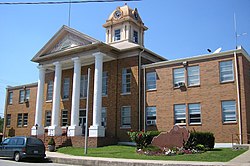
Campton, Kentucky | |
---|---|
Coordinates: 37°44′5″N83°32′54″W / 37.73472°N 83.54833°W | |
Country | United States |
State | Kentucky |
County | Wolfe |
Incorporated | March 17, 1870 |
Government | |
• Type | City Commission |
• Mayor | Katherine May |
Area | |
• Total | 1.00 sq mi (2.59 km2) |
• Land | 1.00 sq mi (2.59 km2) |
• Water | 0.00 sq mi (0.00 km2) |
Elevation | 961 ft (293 m) |
Population (2020) | |
• Total | 316 |
• Density | 316.32/sq mi (122.11/km2) |
Time zone | UTC-5 (Eastern (EST)) |
• Summer (DST) | UTC-4 (EDT) |
ZIP codes | 41301, 41342 |
Area code | 606 |
FIPS code | 21-12358 |
GNIS feature ID | 0511172 |
Campton is a home rule-class city in and the county seat of Wolfe County, Kentucky, United States. [2] The population was 441 at the 2010 census.
Campton was a camp town with a small creek, Swift Creek (named after Jonathan Swift of the legend of Swift's silver mine), running through the town. Swift supposedly buried treasure in the area which has never been recovered.
Campton is located at 37°44′05″N83°32′54″W / 37.734689°N 83.548427°W . [3]
According to the United States Census Bureau, the city has a total area of 1.1 square miles (2.8 km2), of which 1.1 square miles (2.8 km2) is land and 0.04 square miles (0.10 km2) (3.57%) is water.
Census | Pop. | Note | %± |
---|---|---|---|
1870 | 67 | — | |
1880 | 102 | 52.2% | |
1890 | 317 | 210.8% | |
1900 | 276 | −12.9% | |
1910 | 326 | 18.1% | |
1920 | 277 | −15.0% | |
1930 | 337 | 21.7% | |
1940 | 418 | 24.0% | |
1950 | 431 | 3.1% | |
1960 | 484 | 12.3% | |
1970 | 419 | −13.4% | |
1980 | 486 | 16.0% | |
1990 | 484 | −0.4% | |
2000 | 424 | −12.4% | |
2010 | 441 | 4.0% | |
2020 | 316 | −28.3% | |
U.S. Decennial Census [4] |
As of the census [5] of 2000, there were 424 people, 196 households, and 117 families residing in the city. The population density was 393.4 inhabitants per square mile (151.9/km2). There were 229 housing units at an average density of 212.5 per square mile (82.0/km2). The racial makeup of the city was 99.76% White, and 0.24% from two or more races. Hispanic or Latino of any race were 0.71% of the population.
There were 196 households, out of which 28.6% had children under the age of 18 living with them, 41.8% were married couples living together, 16.3% had a female householder with no husband present, and 40.3% were non-families. 37.2% of all households were made up of individuals, and 14.3% had someone living alone who was 65 years of age or older. The average household size was 2.16 and the average family size was 2.85.
In the city, the population was spread out, with 22.4% under the age of 18, 10.4% from 18 to 24, 28.1% from 25 to 44, 23.8% from 45 to 64, and 15.3% who were 65 years of age or older. The median age was 38 years. For every 100 females, there were 88.4 males. For every 100 females age 18 and over, there were 84.8 males.
The median income for a household in the city was $17,778, and the median income for a family was $21,528. Males had a median income of $24,375 versus $21,875 for females. The per capita income for the city was $11,167. About 31.8% of families and 34.6% of the population were below the poverty line, including 47.4% of those under age 18 and 23.6% of those age 65 or over.
Campton has a lending library, the Wolfe County Public Library. [6]
The annual Swift Silver Mine Festival is held on Labor Day weekend each year. It includes a parade and vendors in the downtown area.
Wolfe County is a county located in the U.S. state of Kentucky. As of the 2020 census, the population was 6,562. Its county seat is Campton. The county is named for Nathaniel Wolfe.
Powell County is a county located in the U.S. Commonwealth of Kentucky. As of the 2020 census, the population was 13,129. Its county seat is Stanton. The county was formed January 7, 1852, by Kentucky Governor Lazarus W. Powell from parts of Clark, Estill, and Montgomery counties. It is no longer a dry county as of 2018. Powell County is home to Natural Bridge State Resort Park and the Red River Gorge Geologic Area, two of Kentucky's most important natural areas and ecotourism destinations, as well as the Pilot Knob State Nature Preserve.
Morgan County is a county located in the U.S. state of Kentucky. As of the 2020 census, the population was 13,726. Its county seat is West Liberty. The county is among the dry counties, which means that the sale of alcohol is restricted or prohibited.
Menifee County is a county located in the U.S. state of Kentucky. As of the 2020 census, the population was 6,113, making it the fifth-least populous county in Kentucky. Its county seat is Frenchburg. The county is named for Richard Hickman Menefee, U.S. Congressman, although the spelling has changed. It is a prohibition or dry county. Menifee County is part of the Mount Sterling, KY Micropolitan Statistical Area, which is also included in the Lexington-Fayette-Richmond-Frankfort, KY Combined Statistical Area. It is located in the foothills of the Cumberland Plateau.
Marion County is a county in the U.S. state of Kentucky. As of the 2020 census, the total population was 19,581. Its county seat is Lebanon. The county was founded in 1834 and named for Francis Marion, the American Revolutionary War hero known as the "Swamp Fox".
Brooksville is a home rule-class city in Bracken County, Kentucky, in the United States. As of the 2010 census, the city's population was 642. It is the county seat of Bracken County.
Brownsville is a home rule-class city in Edmonson County, Kentucky, in the United States. It is the county seat and is a certified Kentucky Trail Town. The population was 836 at the time of the 2010 census, down from 921 at the 2000 census. It is included in the Bowling Green metropolitan area. It is just outside Mammoth Cave National Park.
Irvine is a home rule-class city in Estill County, Kentucky, in the United States. It is the seat of its county. Its population was 2,715 at the time of the 2010 census.
Hawesville is a home rule-class city on the south bank of the Ohio River in Hancock County, Kentucky, in the United States. It is the seat of its county. The population was 945 at the 2010 census. It is included in the Owensboro metropolitan area.
Evarts is a home rule-class city in Harlan County, Kentucky, in the United States. The post office was opened on February 9, 1855, and named for one of the area's pioneer families. The city was formally incorporated by the state assembly in 1921. The population was 962 at the 2010 census.
Munfordville is a home rule-class city in, and the county seat of, Hart County, Kentucky, United States. The population was 1,615 at the 2010 U.S. census.
Blackey is an unincorporated community in Letcher County, Kentucky, in the United States. As of the 2010 census, the population was 120. It is located near the early settlement of Indian Bottom. Blackey is thought to have been named after Blackey Brown, one of its citizens.
Frenchburg is a home rule-class city in Menifee County, Kentucky, in the United States. The population was 601 at the 2020 census, up from 486 in 2010. It is the seat and only incorporated city in its rural county. It is located at the junction of U.S. Route 460 and Kentucky Route 36. Logging is the primary industry.
Edmonton is a home rule-class city in and the county seat of Metcalfe County, Kentucky, United States. It is part of the Glasgow Micropolitan Statistical Area. The population was 1,671 at the 2020 census.
Camargo is a home rule-class city in Montgomery County, Kentucky, in the United States. The population was 1,020 at the 2020 census. It is part of the Mount Sterling Micropolitan Statistical Area.
West Liberty is a home rule-class city in Morgan County, Kentucky, United States. It is the county seat of Morgan County. As of the 2020 census, the city population was 3,215. It is located along the Licking River at the junction of Kentucky Route 7 and U.S. Route 460.
Carlisle is a home rule-class city in Nicholas County, Kentucky, United States. The population was 2,010 at the 2010 census. It is the county seat of Nicholas County. It is located at the junction of Kentucky Route 32 and Kentucky Route 36, about halfway between Lexington and Maysville.
Uniontown is a home rule-class city in Union County, Kentucky, United States. The population was 1,002 at the 2010 census. The John T. Myers Locks and Dam, once known as Uniontown Locks and Dam, is located downriver 3½ miles.
Dixon is a home rule-class city in and the county seat of Webster County, Kentucky, United States. The population was 933 at the 2020 census. Dixon is located at the junction of US 41A and KY 132. It was established with a courthouse and post office in 1860 when the county was formed.
Campton is a town in Grafton County, New Hampshire, United States. The population was 3,343 at the 2020 census. Campton, which includes the villages of Blair, Campton Hollow, Lower Campton and West Campton, is home to Blair State Forest and Livermore Falls State Forest. It is located in the foothills of the White Mountains, and parts of the White Mountain National Forest are in the northeast and northwest.