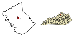
Owenton, Kentucky | |
---|---|
Coordinates: 38°32′19″N84°50′27″W / 38.53861°N 84.84083°W | |
Country | United States |
State | Kentucky |
County | Owen |
Incorporated | 1828 [1] |
Reincorporated | 1849 [1] |
Named for | Its County |
Area | |
• Total | 1.93 sq mi (5.01 km2) |
• Land | 1.90 sq mi (4.92 km2) |
• Water | 0.03 sq mi (0.08 km2) |
Elevation | 958 ft (292 m) |
Population (2020) | |
• Total | 1,682 |
• Estimate (2022) [4] | 1,671 |
• Density | 884.80/sq mi (341.63/km2) |
Time zone | UTC-5 (Eastern (EST)) |
• Summer (DST) | UTC-4 (EDT) |
ZIP code | 40359 |
Area code | 502 |
FIPS code | 21-58692 |
GNIS feature ID | 2404449 [3] |
Owenton is a home rule-class city [5] in and the county seat of Owen County, Kentucky, United States. [6] The population was 1,327 at the 2010 census. It is located at the junction of U.S. Route 127 and Kentucky Route 22, about halfway between Louisville and Cincinnati.
Owenton was founded in 1822 and named for its county, which was named for Col. Abraham Owen, a pioneer who died at the Battle of Tippecanoe. The town was first incorporated on December 18, 1828, although it had to be reincorporated in 1849. [1] The Greek Revival courthouse was built between 1857 and 1858. Owenton's growth in the late 19th century was limited because a railroad was never built to it.
According to the United States Census Bureau, the city has a total area of 2.2 square miles (5.7 km2), of which 2.2 square miles (5.7 km2) is land and 0.04 square miles (0.10 km2) (0.89%) is water.
Census | Pop. | Note | %± |
---|---|---|---|
1830 | 143 | — | |
1860 | 94 | — | |
1870 | 297 | 216.0% | |
1880 | 654 | 120.2% | |
1890 | 847 | 29.5% | |
1900 | 1,014 | 19.7% | |
1910 | 1,024 | 1.0% | |
1920 | 971 | −5.2% | |
1930 | 975 | 0.4% | |
1940 | 1,190 | 22.1% | |
1950 | 1,249 | 5.0% | |
1960 | 1,376 | 10.2% | |
1970 | 1,280 | −7.0% | |
1980 | 1,341 | 4.8% | |
1990 | 1,306 | −2.6% | |
2000 | 1,387 | 6.2% | |
2010 | 1,327 | −4.3% | |
2020 | 1,682 | 26.8% | |
2022 (est.) | 1,671 | [7] | −0.7% |
U.S. Decennial Census [8] |
As of the census [9] of 2000, there were 1,387 people, 615 households, and 340 families residing in the city. The population density was 620.4 inhabitants per square mile (239.5/km2). There were 688 housing units at an average density of 307.8 per square mile (118.8/km2). The racial makeup of the city was 95.39% White, 2.88% African American, 0.58% Asian, 0.07% Pacific Islander, 0.58% from other races, and 0.50% from two or more races. Hispanic or Latino of any race were 1.73% of the population.
There were 615 households, out of which 24.7% had children under the age of 18 living with them, 38.9% were married couples living together, 12.8% had a female householder with no husband present, and 44.7% were non-families. 42.3% of all households were made up of individuals, and 25.2% had someone living alone who was 65 years of age or older. The average household size was 2.08 and the average family size was 2.84.
In the city, the population was spread out, with 20.8% under the age of 18, 8.6% from 18 to 24, 22.4% from 25 to 44, 20.9% from 45 to 64, and 27.3% who were 65 years of age or older. The median age was 44 years. For every 100 females, there were 71.9 males. For every 100 females age 18 and over, there were 65.3 males.
The median income for a household in the city was $23,125, and the median income for a family was $36,806. Males had a median income of $27,596 versus $22,450 for females. The per capita income for the city was $14,955. About 13.2% of families and 21.4% of the population were below the poverty line, including 21.9% of those under age 18 and 28.0% of those age 65 or over.
Owenton has a lending library, the Owen County Public Library. [10]
Owen County is a county located in the northern part of the U.S. state of Kentucky. Its county seat is Owenton. The county is named for Colonel Abraham Owen. It is a prohibition or dry county, with the exception of a winery that is authorized to sell its product to the public, and limited sales within the incorporated city limits of Owenton.
Glencoe is a home rule-class city in Gallatin County, Kentucky, in the United States. The population was 360 as of the 2010 census, up from 251 at the 2000 census.
Munfordville is a home rule-class city in, and the county seat of, Hart County, Kentucky, United States. The population was 1,615 at the 2010 U.S. census.
New Castle is a home rule-class city in Henry County, Kentucky, United States. It is the seat of its county. As of the 2010 census the population was 912.
Bancroft is a home rule-class city in Jefferson County, Kentucky, United States. It was formally incorporated by the state assembly in 1970. The population was 503 as of the 2020 census, up from 494 at the 2010 census.
Bellemeade is a home rule-class city in Jefferson County, Kentucky, United States. It was formally incorporated by the state assembly in 1956. The population was 909 at the 2020 census.
Bellewood is a home rule-class city in Jefferson County, Kentucky, United States. The city was formally incorporated by the state assembly in 1950. The population was 321 at the 2010 census.
Forest Hills is a home rule-class city in Jefferson County, Kentucky, United States. It was formally incorporated by the state assembly in 1959. The population was 444 at the 2010 census.
Glenview Hills is a home rule-class city in Jefferson County, Kentucky, United States. The population was 319 at the 2010 census.
Glenview Manor is a home rule-class city in Jefferson County, Kentucky, United States. The population was 191 at the 2010 census.
Parkway Village is a home rule-class city in Jefferson County, Kentucky, United States, and a part of the Louisville Metro government. It was developed in the 1920s and incorporated in 1941. The population was 650 at the 2010 census.
Fort Mitchell is a home rule-class city in Kenton County, Kentucky, United States. The population was 8,702 at the 2020 census. It is part of the Cincinnati metropolitan area.
Ludlow is a home rule-class city in Kenton County, Kentucky, United States, along the Ohio River. The population was 4,385 at the 2020 census. It is a suburb of the Cincinnati metropolitan area. It received its greatest period of early growth as a rail station.
Villa Hills is a home rule-class city in Kenton County, Kentucky along the Ohio River. The population was 7,310 at the 2020 census.
Whitley City is an unincorporated community and census-designated place (CDP) in McCreary County, Kentucky, United States. The population was 968 at the 2020 census, down from 1,170 in 2010. It is the county seat of McCreary County. Whitley City is one of two unincorporated county seats in Kentucky.
Jeffersonville is a home rule-class city in Montgomery County, Kentucky, in the United States. The population was 1,708 as of the 2020 census, up from 1,506 in 2010. It is part of the Mount Sterling micropolitan area.
Coal Run Village is a home rule-class city in Pike County, Kentucky, in the United States. Bordered to the north, south, and east by Pikeville, the population was 1,706 at the 2010 census. It was the fastest-growing city in Kentucky from 2007 to 2008, with a population increase of 17.3%.
Elkton is a home rule-class city in and the county seat of Todd County, Kentucky, United States. The population was 2,062 at the 2010 census.
Sparta is a home rule-class city in Gallatin and Owen counties in the U.S. state of Kentucky. The population was 231 at the 2010 census.
Corinth is a home rule-class city mostly in Grant County with a small portion of land in Scott County in the U.S. state of Kentucky. The population was 232 as of the 2010 census, up from 181 at the 2000 census.