Hyden, Kentucky | |
---|---|
Nickname(s): Redbud Capital of the World | |
Coordinates: 37°9′48″N83°22′30″W / 37.16333°N 83.37500°W Coordinates: 37°9′48″N83°22′30″W / 37.16333°N 83.37500°W | |
Country | United States |
State | Kentucky |
County | Leslie |
Incorporated | March 18, 1882 |
Government | |
• Type | City Commission |
• Mayor | Carol Lewis Joseph |
Area | |
• Total | 1.34 sq mi (3.46 km2) |
• Land | 1.30 sq mi (3.36 km2) |
• Water | 0.04 sq mi (0.10 km2) |
Elevation | 922 ft (281 m) |
Population (2020) | |
• Total | 303 |
• Density | 233.80/sq mi (90.27/km2) |
Time zone | UTC-5 (Eastern (EST)) |
• Summer (DST) | UTC-4 (EDT) |
ZIP codes | 41749, 41762 |
Area code(s) | 606 |
FIPS code | 21-38908 |
GNIS feature ID | 0512880 |
Website | www |
Hyden is a home rule-class city in and the county seat of Leslie County, Kentucky, United States. [2] The population was 365 at the 2010 census. [3] It is located at the junction of U.S. Route 421 and Kentucky Route 80, along the Middle Fork of the Kentucky River.
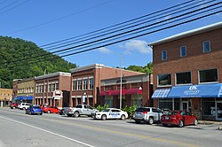
The area was first settled around 1800 by the Sizemores, a mixed-blood (Anglo and Native-American) family migrating from North Carolina, with a brief stay in Hawkins County, Tennessee, before making it to Kentucky. John "Rock House" Sizemore and his wife, Nancy (Bowling) Sizemore, lived in a rock house about a hundred yards up from the mouth of the creek which would later bear his name (Rockhouse Creek). John Rock House later sold the land to a Lewis man who then donated the land to the government, which became the town of Hyden. The town was established in 1878 and incorporated in 1882, and was named after John Hyden, a state senator of the time who helped form Leslie County. [4] The mountainous terrain made the region difficult to access except by river, which was no longer the dominant form of transportation by the late 19th century, hindering growth.
Frontier Nursing University opened in Hyden in 1939.
Hyden briefly came to national attention when the Hurricane Creek mine disaster occurred in late 1970, 5 miles (8 km) southeast of the city. [5]
In July 1978, Richard Nixon came to Hyden to make his first public speech since resigning from the presidency during the Watergate crisis. [6] Hyden was picked because Congressman Tim Lee Carter invited him to attend the dedication of a recreation facility and Nixon wanted a town that had heavily supported his presidential runs. Leslie County Judge-Executive C. Allen Muncy claimed the Nixon invitation prompted the U.S. Department of Justice to obtain indictments of him and his associates on vote-fraud charges; while on appeal for his conviction, he won renomination in the Republican primary but lost the 1981 general election to independent Kermit Keen. [7]
Hyden is located in north-central Leslie County at 37°9′48″N83°22′30″W / 37.16333°N 83.37500°W (37.163456, -83.375065), [8] in the valley of the Middle Fork of the Kentucky River. Most of the city is on the west side of the river, at the confluence of Rockhouse Creek from the west.
U.S. Route 421 and Kentucky Route 80 pass through Hyden as its Main Street, leading west 31 miles (50 km) to Manchester. In the other direction, US 421 leads south up the Middle Fork valley and over Pine Mountain 34 miles (55 km) to Harlan, while KY 80 leads northeast 17 miles (27 km) to Combs, near Hazard. Kentucky Route 118 (Tim Couch Pass) is a three-lane highway leading northwest from Hyden 4 miles (6 km) to the Hal Rogers Parkway at Thousandsticks. Kentucky Route 257 (Dryhill Road) is a local road that leads north from Hyden down the valley of the Middle Fork 11 miles (18 km) to Confluence.
According to the United States Census Bureau, Hyden has a total area of 1.4 square miles (3.5 km2), of which 0.04 square miles (0.1 km2), or 2.99%, are water. [9]
The climate in this area is characterized by hot, humid summers and generally mild to cool winters. According to the Köppen Climate Classification system, Hyden has a humid subtropical climate, abbreviated "Cfa" on climate maps. [10]
Historical population | |||
---|---|---|---|
Census | Pop. | %± | |
1890 | 80 | — | |
1900 | 269 | 236.3% | |
1910 | 316 | 17.5% | |
1920 | 313 | −0.9% | |
1950 | 647 | — | |
1960 | 348 | −46.2% | |
1970 | 482 | 38.5% | |
1980 | 488 | 1.2% | |
1990 | 375 | −23.2% | |
2000 | 204 | −45.6% | |
2010 | 365 | 78.9% | |
2020 | 303 | −17.0% | |
U.S. Decennial Census [11] |
As of the census [12] of 2000, there were 204 people, 95 households, and 58 families residing in the city. The population density was 256.0 people per square mile (98.5/km2). There were 112 housing units at an average density of 140.6 per square mile (54.1/km2). The racial makeup of the city was 99.51% White and 0.49% Native American. Hispanic or Latino of any race were 0.98% of the population.
There were 95 households, out of which 18.9% had children under the age of 18 living with them, 41.1% were married couples living together, 15.8% had a female householder with no husband present, and 38.9% were non-families. 36.8% of all households were made up of individuals, and 21.1% had someone living alone who was 65 years of age or older. The average household size was 2.07 and the average family size was 2.69.
In the city, the population was spread out, with 15.7% under the age of 18, 10.3% from 18 to 24, 20.6% from 25 to 44, 27.9% from 45 to 64, and 25.5% who were 65 years of age or older. The median age was 48 years. For every 100 females, there were 74.4 males. For every 100 females age 18 and over, there were 68.6 males.
The median income for a household in the city was $26,429, and the median income for a family was $32,500. Males had a median income of $24,792 versus $31,250 for females. The per capita income for the city was $13,966. About 3.2% of families and 10.5% of the population were below the poverty line, including none of those under the age of eighteen and 24.4% of those 65 or over.
Hyden has a lending library, the Leslie County Public Library. [13]
Perry County is a county in the U.S. state of Kentucky. As of the 2020 census, the population was 28,473. Its county seat is Hazard. The county was founded in 1820. Both the county and county seat are named for Commodore Oliver Hazard Perry, a naval hero in the War of 1812.
Leslie County is located in the U.S. state of Kentucky. Its county seat is Hyden. Leslie is a prohibition or dry county.
Burlington is a census-designated place (CDP) in and the county seat of Boone County, Kentucky, United States. The population was 15,926 at the 2010 census.
Albany is a home rule-class city in Clinton County, Kentucky, in the United States. The population was 2,033 at the 2010 census. It is the county seat of Clinton County. It is located on U.S. Route 127, about 6 miles (10 km) north of the Tennessee border.
Caneyville is a home rule-class city in Grayson County, Kentucky, in the United States. The population was 608 at the 2010 census. Named for its location on Caney Creek, Caneyville had a post office by 1837 and a town charter by 1840 and was incorporated by the state legislature in 1880.
Cumberland is a home rule-class city in Harlan County, Kentucky, in the United States. The population according to the 2010 Census was 2,237, down from 2,611 at the 2000 census.
Evarts is a home rule-class city in Harlan County, Kentucky, in the United States. The post office was opened on February 9, 1855, and named for one of the area's pioneer families. The city was formally incorporated by the state assembly in 1921. The population was 962 at the 2010 census.
Harlan is a home rule-class city in and the county seat of Harlan County, Kentucky, United States. The population was 1,745 at the 2010 census, down from 2,081 at the 2000 census.
McKee is a home rule-class city in Jackson County, Kentucky, in the United States. It is the seat of its county. The population was 800 at the 2010 census. The city was named for Judge George R. McKee. In 2019, the city had a vote whether to continue the prohibition of alcohol sales within the city limits, and the votes came back in favor of making the city wet.
Hodgenville is a home rule-class city in LaRue County, Kentucky, United States. It is the seat of its county. Hodgenville sits along the North Fork of the Nolin River. The population was 3,206 at the 2010 census. It is included in the Elizabethtown metropolitan area.
Blaine is a home rule-class city in Lawrence County, Kentucky, United States. The population was 47 at the 2010 census, down from 245 at the 2000 census.
Louisa is a home rule-class city located at the merger of the Levisa and Tug Forks into the Big Sandy River. It is located in Lawrence County, Kentucky, in the United States, and is the seat of its county. The population was 2,467 at the 2010 census and an estimated 2,375 in 2018.
Blackey is an unincorporated community in Letcher County, Kentucky, in the United States. As of the 2010 census, the population was 120. It is located near the early settlement of Indian Bottom. Blackey is thought to have been named after Blackey Brown, one of its citizens.
Carrsville is a home rule-class city beside the Ohio River in Livingston County, Kentucky, in the United States. The population was 50 at the 2010 census, declining from 64 as of 2000. It is part of the Paducah, KY-IL Micropolitan Statistical Area. It is situated just west of the junction of where Buck Creek empties into the Ohio River.
Bradfordsville is a home rule-class city in Marion County, Kentucky, in the United States. The population was 304 at the time of the 2000 census.
Warfield is a home rule-class city in Martin County, Kentucky, United States. The population was 269 at the 2010 census.
Vicco is a home rule-class city in Perry and Knott counties, Kentucky, United States. The population was 334 at the 2010 census. On January 16, 2013, Vicco became the smallest city in the United States to pass an ordinance outlawing discrimination based on sexual orientation.
Kermit is a town in Mingo County, West Virginia, United States. The population was 406 at the 2010 census. Kermit is located along the Tug Fork, opposite Warfield, Kentucky. The Norfolk Southern Railway's Kenova District runs through town.
Williamson is a city in Mingo County, West Virginia, United States, situated along the Tug Fork River. The population was 3,191 at the 2010 census. It is the county seat of Mingo County, and is the county's largest and most populous city. Williamson is home to Southern West Virginia Community and Technical College. The Tug Fork River separates Williamson from South Williamson, Kentucky.
Williamstown is a home-rule-class city in Grant and Pendleton counties in the U.S. state of Kentucky. The population was 3,925 at the 2010 census, up from 3,227 as of the 2000 census. It is the county seat of Grant County.