Morgantown, Kentucky

Last updated
Morgantown, Kentucky
Butler County Courthouse Kentucky.jpg
Butler County Courthouse in Morgantown
Flag of Morgantown, Kentucky.svg
Butler County Kentucky Incorporated and Unincorporated areas Morgantown Highlighted 2153490.svg
Location of Morgantown in Butler County, Kentucky.
Coordinates: 37°13′10″N86°41′33″W / 37.21944°N 86.69250°W / 37.21944; -86.69250
Country United States
State Kentucky
County Butler
Incorporated1813;210 years ago (1813) [1]
Government
  MayorBilly Phelps
Area
[2]
  Total3.35 sq mi (8.69 km2)
  Land3.33 sq mi (8.62 km2)
  Water0.03 sq mi (0.07 km2)
Elevation
[3]
568 ft (173 m)
Population
 (2020)
  Total2,505
  Estimate 
(2022) [4]
2,467
  Density752.93/sq mi (290.73/km2)
Time zone UTC-6 (CST)
  Summer (DST) UTC-5 (CDT)
ZIP Code
42261
Area code(s) 270 & 364
FIPS code 21-53490
GNIS feature ID0498600 [3]
Website www.morgantown-ky.com

Morgantown is a home rule-class city [5] in, and the seat of Butler County, Kentucky, United States. [6] The population was 2,471 at the time of the 2020 Census. [7]

Contents

History

Buildings on the western side of the 100 block of N. Main Street in Morgantown Main Street Morgantown.jpg
Buildings on the western side of the 100 block of N. Main Street in Morgantown

The settlement may have originally been called Funkhouser Hill after Christopher Funkhouser, the local landowner who donated 60 acres (24 ha) of land to establish a seat for the newly formed Butler County in 1811. [8] The etymology of the city's present name (originally written Morgan Town) is uncertain. It may have been chosen to honor a hunter named Morgan or to honor Daniel Morgan Smith, the first white child born in the town. [9] It was incorporated as Morgantown by the state assembly in 1813, [1] although the post office also went by the name Butler Court House during the 19th century. [8]

Granville Allen, a member of the 17th Kentucky Infantry, was one of the first Union soldiers to die in the Civil War, in a skirmish on October 29, 1861. A monument was erected by the Granville Allen Post #93 GAR. This first skirmish between the North and South took place on the Daniel Boone Johnson property. The Johnson Cemetery is still there and is directly above the monument, which is a limestone marker cut into the side of the old Logansport road.

Morgantown has one of only two monuments in the country dedicated to soldiers of both sides who died in the Civil War. The Confederate-Union Veterans' Monument in Morgantown is located on the grounds of the county courthouse.

The city formerly had a sister city in Tatsuruhama, Japan, but that city is now part of Nanao.

Geography

Morgantown is located near the center of Butler County at 37°13′10″N86°41′33″W / 37.21944°N 86.69250°W / 37.21944; -86.69250 (37.219465, -86.692513). [10] It is situated on the top of a bluff on the west side of the Green River.

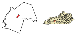
According to the United States Census Bureau, the city has a total area of 2.4 square miles (6.3 km2), of which 0.012 square miles (0.03 km2), or 0.49%, is water. [7]

Climate

The climate in this area is characterized by hot, humid summers and generally mild to cool winters. According to the Köppen Climate Classification system, Morgantown has a humid subtropical climate, abbreviated "Cfa" on climate maps. [11]

Demographics

Historical population
CensusPop.Note
1850 89
1860 12540.4%
1870 1250.0%
1880 20463.2%
1890 25022.5%
1900 587134.8%
1910 569−3.1%
1920 70724.3%
1930 551−22.1%
1940 85955.9%
1950 850−1.0%
1960 1,31855.1%
1970 1,3945.8%
1980 2,00043.5%
1990 2,28414.2%
2000 2,54411.4%
2010 2,394−5.9%
2020 2,5054.6%
2022 (est.)2,467 [12] −1.5%
U.S. Decennial Census [13]

As of the census [14] of 2000, there were 2,544 people, 1,051 households, and 627 families residing in the city. The population density was 754.8 inhabitants per square mile (291.4/km2). There were 1,148 housing units at an average density of 340.6 per square mile (131.5/km2). The racial makeup of the city was 95.52% White, 1.10% African American, 0.16% Native American, 0.31% Asian, 2.36% from other races, and 0.55% from two or more races. Hispanic or Latino of any race were 3.22% of the population.

There were 1,051 households, out of which 29.0% had children under the age of 18 living with them, 40.9% were married couples living together, 15.3% had a female householder with no husband present, and 40.3% were non-families. 36.9% of all households were made up of individuals, and 18.5% had someone living alone who was 65 years of age or older. The average household size was 2.23 and the average family size was 2.90.

In the city, the population was spread out, with 23.0% under the age of 18, 11.2% from 18 to 24, 24.8% from 25 to 44, 21.0% from 45 to 64, and 19.9% who were 65 years of age or older. The median age was 38 years. For every 100 females, there were 82.9 males. For every 100 females age 18 and over, there were 76.9 males.

The median income for a household in the city was $19,912, and the median income for a family was $27,218. Males had a median income of $24,671 versus $18,594 for females. The per capita income for the city was $12,100. About 24.9% of families and 27.6% of the population were below the poverty line, including 36.0% of those under age 18 and 21.2% of those age 65 or over.

In 2010, Morgantown had the 16th-lowest median household income of all places in the United States with a population over 1,000. [15]

Transportation

Morgantown exit on William H. Natcher Parkway (now Interstate 165) in 2014 William H. Natcher Parkway - Morgantown exit 4-10-2014.jpg
Morgantown exit on William H. Natcher Parkway (now Interstate 165) in 2014

Prior to 1917, the city's primary channel of transportation was the Green River. However, in 1917, the river froze, leaving the city without supplies for two months. A subsequent period of road-building began, and in 1930, a road connecting Morgantown with Bowling Green provided an alternate conduit for commerce. [9]

Morgantown is now served by Interstate 165 and it is along the proposed Interstate 67 corridor. Via I-165 it is 23 miles (37 km) southeast to Bowling Green and 48 miles (77 km) north to Owensboro on the Ohio River. Other major roads serving the city include U.S. Highway 231, Kentucky Route 70, and Kentucky Route 79. Kentucky Route 403 is a minor artery in and out of town.

The city does not have railroad service.

Education

Morgantown is home to these public schools as part of the Butler County Schools District:

Morgantown also has a lending library, the Butler County Public Library. [16]

Arts and culture

Morgantown's municipal park, Charles Black City Park, is home to the annual Green River Catfish Festival held the week of July 4. [9] The festival has been held annually since July 1980. In addition to the city park, the catfish festival also includes a catfish tournament on the Green River, where the grand prize is $2,500. [17]

Notable people

Related Research Articles

<span class="mw-page-title-main">Butler County, Kentucky</span> County in Kentucky, United States

Butler County is a county located in the US state of Kentucky. As of the 2020 Census, the population was 12,371. Its county seat is Morgantown. The county was formed in 1810, becoming Kentucky's 53rd county. Butler County is included in the Bowling Green, Kentucky, Metropolitan Statistical Area.

<span class="mw-page-title-main">Bath County, Kentucky</span> County in Kentucky, United States

Bath County is a county located in the U.S. state of Kentucky. As of the 2020 census, the population was 12,750. The county seat is Owingsville. The county was formed in 1811. Bath County is included in the Mount Sterling, KY Micropolitan Statistical Area, which is also included in the Lexington-Fayette-Richmond-Frankfort, KY Combined Statistical Area.

<span class="mw-page-title-main">Augusta, Kansas</span> City in Butler County, Kansas

Augusta is a city in Butler County, Kansas, United States. As of the 2020 census, the population of the city was 9,256.

<span class="mw-page-title-main">Bazine, Kansas</span> City in Ness County, Kansas

Bazine is a city in Ness County, Kansas, United States. As of the 2020 census, the population of the city was 282.

<span class="mw-page-title-main">Rochester, Kentucky</span> City in Kentucky

Rochester is a home rule-class city in Butler County, Kentucky, United States, at the confluence of the Green and Mud rivers. The population was 114 as of the 2020 Census

<span class="mw-page-title-main">Woodbury, Kentucky</span> City in Kentucky, United States

Woodbury is a home rule-class city in Butler County, Kentucky, United States. The population was 90 at the 2010 census.

<span class="mw-page-title-main">Liberty, Kentucky</span> City in Kentucky, United States

Liberty is a home rule-class city in Casey County, Kentucky, in the United States. It is the seat of its county. Its population was 2,168 at the 2010 U.S. census.

<span class="mw-page-title-main">Lancaster, Kentucky</span> City in Kentucky, United States

Lancaster is a home rule-class city in Garrard County, Kentucky, in the United States. It is the seat of its county. As of the year 2010 U.S. census, the city population was 3,442.

<span class="mw-page-title-main">Greensburg, Kentucky</span> City in Kentucky, United States

Greensburg is a home rule-class city in and the county seat of Green County, Kentucky, United States. The population was 2,163 at the 2010 census, down from 2,396 at the 2000 census.

<span class="mw-page-title-main">Green Spring, Kentucky</span> City in Kentucky, United States

Green Spring is a home rule-class city in Jefferson County, Kentucky, United States. The population was 715 at the 2010 census.

<span class="mw-page-title-main">Hodgenville, Kentucky</span> City in Kentucky, United States

Hodgenville is a home rule-class city in LaRue County, Kentucky, United States. It is the seat of its county. Hodgenville sits along the North Fork of the Nolin River. The population was 3,206 at the 2010 census. It is included in the Elizabethtown metropolitan area.

<span class="mw-page-title-main">Calhoun, Kentucky</span> City in Kentucky, United States

Calhoun is a home rule-class city in McLean County, Kentucky, United States. The population was 725 at the 2020 census. It is the county seat of McLean County. It is included in the Owensboro, Kentucky Metropolitan Statistical Area.

<span class="mw-page-title-main">Island, Kentucky</span> City in Kentucky, United States

Island is a home rule-class city in McLean County, Kentucky, in the United States. The population was 429 at the 2020 census. It is included in the Owensboro metropolitan area.

<span class="mw-page-title-main">Frenchburg, Kentucky</span> City in Kentucky, United States

Frenchburg is a home rule-class city in Menifee County, Kentucky, in the United States. The population was 601 at the 2020 census, up from 486 in 2010. It is the seat and only incorporated city in its rural county. It is located at the junction of U.S. Route 460 and Kentucky Route 36. Logging is the primary industry.

<span class="mw-page-title-main">Edmonton, Kentucky</span> City in Kentucky, United States

Edmonton is a home rule-class city in and the county seat of Metcalfe County, Kentucky, United States. It is part of the Glasgow Micropolitan Statistical Area. The population was 1,671 at the 2020 census.

<span class="mw-page-title-main">Gamaliel, Kentucky</span> City in Kentucky, United States

Gamaliel is a home rule-class city in Monroe County, Kentucky, in the United States. The population was 391 at the 2020 census.

<span class="mw-page-title-main">Mount Sterling, Kentucky</span> City in Kentucky, United States

Mount Sterling, often written as Mt. Sterling, is a home rule-class city in Montgomery County, Kentucky, United States. The population was 7,558 as of the 2020 census, up from 6,895 in 2010. It is the county seat of Montgomery County and the principal city of the Mount Sterling micropolitan area.

<span class="mw-page-title-main">Sturgis, Kentucky</span> City in Kentucky, United States

Sturgis is a home rule-class city in Union County, Kentucky, United States. The population was 1,898 at the 2010 census. Located in northwest Kentucky, the city was founded in 1890 and named for Samuel Sturgis, who owned the land now occupied by the city.

<span class="mw-page-title-main">Springfield, Kentucky</span> City in Kentucky, United States

Springfield is a home rule-class city in and county seat of Washington County, Kentucky, United States. The population was 2,846 at the 2020 census.

<span class="mw-page-title-main">Williamstown, Kentucky</span> City in Kentucky, United States

Williamstown is a home-rule-class city in Grant and Pendleton counties in the U.S. state of Kentucky. The population was 3,925 at the 2010 census, up from 3,227 as of the 2000 census. It is the county seat of Grant County.

References

  1. 1 2 Commonwealth of Kentucky. Office of the Secretary of State. Land Office. "Morgantown, Kentucky". Accessed 26 August 2013.
  2. "2020 U.S. Gazetteer Files". United States Census Bureau. Retrieved March 18, 2022.
  3. 1 2 U.S. Geological Survey Geographic Names Information System: Morgantown, Kentucky
  4. "Annual Estimates of the Resident Population for Incorporated Places in Kentucky: April 1, 2020 to July 1, 2022". United States Census Bureau. Retrieved May 26, 2023.
  5. "Summary and Reference Guide to House Bill 331 City Classification Reform" (PDF). Kentucky League of Cities. Retrieved December 30, 2014.
  6. "Find a County". National Association of Counties. Retrieved 2011-06-07.
  7. 1 2 "Geographic Identifiers: 2010 Demographic Profile Data (G001): Morgantown city, Kentucky". U.S. Census Bureau, American Factfinder. Archived from the original on February 12, 2020. Retrieved November 27, 2013.
  8. 1 2 Rennick, Robert. Kentucky Place Names, p. 203. University Press of Kentucky (Lexington), 1987. Accessed 1 August 2013.
  9. 1 2 3 Kleber, John E., ed. (1992). "Morgantown". The Kentucky Encyclopedia. Lexington, Ky.: The University Press of Kentucky. ISBN   0-8131-1772-0.
  10. "US Gazetteer files: 2010, 2000, and 1990". United States Census Bureau. 2011-02-12. Retrieved 2011-04-23.
  11. Climate Summary for Morgantown, Kentucky
  12. "Annual Estimates of the Resident Population for Incorporated Places in Kentucky: April 1, 2020 to July 1, 2022". United States Census Bureau. Retrieved May 26, 2023.
  13. "Census of Population and Housing". Census.gov. Retrieved June 4, 2015.
  14. "U.S. Census website". United States Census Bureau . Retrieved 2008-01-31.
  15. "US Census". Archived from the original on 12 February 2020. Retrieved 18 January 2014.
  16. "Kentucky Public Library Directory". Kentucky Department for Libraries and Archives. Archived from the original on 11 January 2019. Retrieved 5 June 2019.
  17. Mudd, Aaron (July 1, 2017). “Morgantown Catfish Festival Turns 37.” Bowling Green Daily News , July 1, 2017, page 7A.
  18. "Wabash Valley College roster". National Junior College Athletic Association. 2013. Archived from the original on 3 December 2013. Retrieved 7 June 2013.
  19. "University of Kentucky Swimming Roster". University of Kentucky Athletics. Archived from the original on 5 November 2016. Retrieved 14 November 2016.