
Louisville is the most populous city in the Commonwealth of Kentucky, sixth-most populous city in the Southeast, and the 27th-most-populous city in the United States. By land area, it is the country's 24th-largest city. Louisville is the historical county seat and, since 2003, the nominal seat of Jefferson County, on the Indiana border.

Owsley County is a county located in the Eastern Coalfield region of the U.S. state of Kentucky. As of the 2020 census, the population was 4,051, making it the second-least populous county in Kentucky. The county seat is Booneville. The county was organized on January 23, 1843, from Clay, Estill, and Breathitt counties and named for William Owsley (1782–1862), the judge of the Kentucky Court of Appeals and Governor of Kentucky (1844–48). According to the 2010 census reports, Owsley County has the second-highest level of child poverty of any county in the United States. In terms of income per household, the county is the poorest in the nation. Between 1980 and 2014, the rate of death from cancer in the county increased by 45.6 percent, the largest such increase of any county in the United States.

Christian County is a county located in the U.S. state of Kentucky. As of the 2020 census, the population was 72,748. Its county seat is Hopkinsville. The county was formed in 1797. Christian County is part of the Clarksville, Tennessee–Kentucky Metropolitan Statistical Area.
Carrollton is a home rule-class city in—and the county seat of—Carroll County, Kentucky, United States, at the confluence of the Ohio and Kentucky rivers. The population was 3,938 at the 2010 census.

Elizabethtown is a home rule-class city and the county seat of Hardin County, Kentucky, United States. The population was 28,531 at the 2010 census, and was estimated at 31,394 by the U.S. Census Bureau in 2020, making it the 11th-largest city in the state. It is included in the Elizabethtown–Fort Knox, Kentucky Metropolitan Statistical Area, which is included in the Louisville/Jefferson County–Elizabethtown–Madison, Kentucky-Indiana Combined Statistical Area. The Elizabethtown Metropolitan area had a 2019 estimated population of 153,057, making it the 5th-largest metropolitan area in the state.

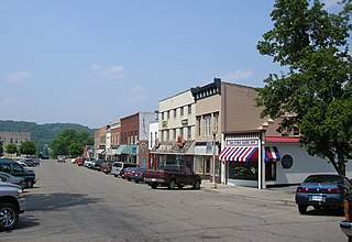
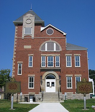
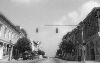
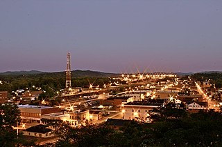
Beattyville is a home rule class city in, and the county seat of, Lee County, Kentucky, United States. The city was formally established by the state assembly as "Beatty" in 1851 and incorporated in 1872. It was named for Samuel Beatty, a pioneer settler. The population was 1,307 at the 2010 census and an estimated 1,206 in 2018.

Hazard is a home rule-class city in, and the county seat of, Perry County, Kentucky, United States. The population was 5,263 at the 2020 Census.
Morehead is a home rule-class city located along US 60 and Interstate 64 in Rowan County, Kentucky, in the United States. It is the seat of its county. The population was 7,151 at the time of the 2020 U.S. census.
Shelbyville is a home rule-class city in and the county seat of Shelby County, Kentucky, United States. The population was 17,282 at the 2020 census.
Corbin is a home rule-class city in Whitley, Knox and Laurel counties in the southeastern portion of the U.S. state of Kentucky. As of the 2020 census, the city population was 7,856.

Northern Kentucky is an urban area in the U.S. Commonwealth of Kentucky compromising the southern part of the Cincinnati metropolitan area. The three main counties of the area are Boone, Kenton, and Campbell, all along the Ohio River across from Cincinnati, Ohio. Other counties frequently included in Northern Kentucky include Bracken, Grant, Gallatin and Pendleton. Of Greater Cincinnati's over two million residents, over 450,000 of them live in Northern Kentucky as of 2020, primarily in the northernmost counties. The largest cities in the region are Covington, Florence, and Independence.

Wendell Erdman Berry is an American novelist, poet, essayist, environmental activist, cultural critic, and farmer. Closely identified with rural Kentucky, Berry developed many of his agrarian themes in the early essays of The Gift of Good Land (1981) and The Unsettling of America (1977). His attention to the culture and economy of rural communities is also found in the novels and stories of Port William, such as A Place on Earth (1967), Jayber Crow (2000), and That Distant Land (2004).

Pleasant Hill, Kentucky, USA, is the site of a Shaker religious community that was active from 1805 to 1910. Following a preservationist effort that began in 1961, the site, now a National Historic Landmark, has become a popular tourist destination. Shaker Village of Pleasant Hill, or Shakertown, as it is known by residents of the area, is located 25 miles (40 km) southwest of Lexington, in Kentucky's Bluegrass region. It is a National Historic Landmark District.
Buckhorn Lake, located south of Buckhorn, Kentucky, United States and northwest of Hazard, Kentucky off Kentucky Route 28, is a 1,230-acre (5 km2) reservoir created by the United States Army Corps of Engineers in 1967 by impounding the Middle Fork of the Kentucky River. The lake was flooded over top of a small township called Bowlingtown.
Berrytown is a neighborhood of Louisville, Kentucky, United States, which has historically been a predominantly African-American community. Its location is centered along English Station Road, on the eastern boundary of the city of Anchorage, Kentucky.
Lake Dreamland is a neighborhood of Louisville, Kentucky located along Campground Road and the Ohio River.

The Episcopal Diocese of Kentucky is a diocese of the Episcopal Church in the United States of America, encompassing the western half of the state of Kentucky.
Fixer is an unincorporated community in Lee County, Kentucky, United States.
Garden Village is an unincorporated community in Pike County, Kentucky. It is located on the Levisa Fork of the Big Sandy River, below the Peyton Branch and 4 miles (6.4 km) southeast of Pikeville.


