Mount Vernon, Kentucky

Last updated

Mount Vernon, Kentucky
Mount Vernon downtown, Main at Church.jpg
Downtown Mount Vernon (2011)
Rockcastle County Kentucky Incorporated and Unincorporated areas Mount Vernon Highlighted 2154174.svg
Location within Rockcastle County & Kentucky
Coordinates: 37°22′08″N84°20′05″W / 37.36889°N 84.33472°W / 37.36889; -84.33472
Country United States
State Kentucky
County Rockcastle
Incorporated1818 [1]
Reïncorporated1866 [1]
Named for George Washington's Virginia home
Area
[2]
  Total2.83 sq mi (7.32 km2)
  Land2.81 sq mi (7.29 km2)
  Water0.01 sq mi (0.03 km2)
Elevation
[3]
1,221 ft (372 m)
Population
 (2020)
  Total2,453
  Estimate 
(2022) [4]
2,472
  Density871.71/sq mi (336.52/km2)
Time zone UTC-5 (Eastern (EST))
  Summer (DST) UTC-4 (EDT)
ZIP code
40456
Area code 606
FIPS code 21-54174
GNIS feature ID2404325 [3]
Website City website

Mount Vernon is a home rule-class city [5] and the seat of Rockcastle County in southeastern Kentucky. The intersection of U.S. Routes 25 and 150 is located here. The population was 2,477 at the time of the 2010 U.S. census. Mount Vernon is part of the Richmond-Berea micropolitan area.

Contents

History

Mount Vernon City Hall Mount Vernon Ketucky City Hall.JPG
Mount Vernon City Hall

The area was first settled by European Americans in 1790 after the American Revolutionary War, around a feature called Spout Springs. Much of the area was originally swampland. The settlement was named for George Washington's home, Mount Vernon. The Wilderness Road was constructed to this town in 1792, and this was the principal settlement when Rockcastle Co. was created in 1810.

In 1883, an L&N spur was built through the town, connecting it by rail to Louisville and Knoxville. The county's first newspaper, the Mount Vernon Signal, began publication in 1887. Although it was still a largely rural town and county in the late 20th century, the construction of I-75 in the 1970s has drawn some industry to the area. The population has increased about 50% from 1,639 in 1970.

Geography

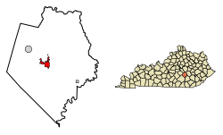
Mount Vernon is located within the Cumberland Plateau region of the state along Interstate 75 and U.S. Routes 25 and 150. I-75 runs to the east of the city, with access from exits 59 and 62. Via I-75, Lexington is 55 mi (89 km) north, and Knoxville, Tennessee is 119 mi (192 km) south. U.S. 25 meets U.S. 150 in the center of town, with U.S. 25 leading north 17 mi (27 km) to Berea and southeast 9 mi (14 km) to Livingston, and U.S. 150 leading northwest 25 mi (40 km) to Stanford.

According to the United States Census Bureau, the city has a total area of 3.7 square miles (9.6 km2), of which 3.2 square miles (8.3 km2) is land and 0.5 square miles (1.3 km2) (14.56%) is water.

Climate

Climate data for Mount Vernon, Kentucky (1991–2020 normals, extremes 1956–2016)
MonthJanFebMarAprMayJunJulAugSepOctNovDecYear
Record high °F (°C)76
(24)
79
(26)
86
(30)
91
(33)
91
(33)
101
(38)
102
(39)
102
(39)
97
(36)
91
(33)
82
(28)
78
(26)
102
(39)
Mean maximum °F (°C)64.8
(18.2)
69.6
(20.9)
77.0
(25.0)
83.8
(28.8)
85.9
(29.9)
90.2
(32.3)
92.1
(33.4)
93.0
(33.9)
90.1
(32.3)
83.3
(28.5)
75.8
(24.3)
65.5
(18.6)
93.9
(34.4)
Mean daily maximum °F (°C)42.3
(5.7)
46.6
(8.1)
55.6
(13.1)
67.0
(19.4)
74.5
(23.6)
81.5
(27.5)
84.4
(29.1)
84.2
(29.0)
79.3
(26.3)
68.5
(20.3)
56.1
(13.4)
46.3
(7.9)
65.5
(18.6)
Daily mean °F (°C)33.4
(0.8)
37.0
(2.8)
45.1
(7.3)
55.4
(13.0)
64.1
(17.8)
71.7
(22.1)
75.2
(24.0)
74.1
(23.4)
67.9
(19.9)
56.6
(13.7)
45.6
(7.6)
37.6
(3.1)
55.3
(12.9)
Mean daily minimum °F (°C)24.5
(−4.2)
27.3
(−2.6)
34.6
(1.4)
43.8
(6.6)
53.7
(12.1)
62.0
(16.7)
66.0
(18.9)
63.9
(17.7)
56.6
(13.7)
44.8
(7.1)
35.0
(1.7)
29.0
(−1.7)
45.1
(7.3)
Mean minimum °F (°C)1.1
(−17.2)
7.1
(−13.8)
16.5
(−8.6)
26.1
(−3.3)
36.0
(2.2)
47.5
(8.6)
53.4
(11.9)
52.1
(11.2)
40.1
(4.5)
28.5
(−1.9)
19.4
(−7.0)
7.8
(−13.4)
−1.7
(−18.7)
Record low °F (°C)−24
(−31)
−17
(−27)
−8
(−22)
17
(−8)
27
(−3)
36
(2)
45
(7)
38
(3)
33
(1)
19
(−7)
6
(−14)
−16
(−27)
−24
(−31)
Average precipitation inches (mm)4.22
(107)
4.02
(102)
4.86
(123)
4.79
(122)
4.86
(123)
4.79
(122)
4.59
(117)
3.65
(93)
3.54
(90)
3.59
(91)
3.50
(89)
4.94
(125)
51.35
(1,304)
Average snowfall inches (cm)3.1
(7.9)
4.0
(10)
2.0
(5.1)
0.0
(0.0)
0.0
(0.0)
0.0
(0.0)
0.0
(0.0)
0.0
(0.0)
0.0
(0.0)
0.0
(0.0)
0.2
(0.51)
1.6
(4.1)
10.9
(28)
Average precipitation days (≥ 0.01 in)12.410.212.611.812.611.211.78.88.28.710.012.8131.0
Average snowy days (≥ 0.1 in)2.12.11.00.00.00.00.00.00.00.00.21.26.6
Source: NOAA (mean maxima/minima 19812010) [6] [7]

Demographics

Historical population
CensusPop.Note
1830 142
1840 20947.2%
1860 156
1870 25261.5%
1880 90−64.3%
1900 422
1910 930120.4%
1920 719−22.7%
1930 93930.6%
1940 1,10017.1%
1950 1,1060.5%
1960 1,1776.4%
1970 1,63939.3%
1980 2,33442.4%
1990 2,65413.7%
2000 2,592−2.3%
2010 2,477−4.4%
2020 2,453−1.0%
2022 (est.)2,472 [8] 0.8%
U.S. Decennial Census [9]

As of the census [10] of 2000, there were 2,592 people, 1,126 households, and 681 families residing in the city. The population density was 816.2 inhabitants per square mile (315.1/km2). There were 1,241 housing units at an average density of 390.8 per square mile (150.9/km2). The racial makeup of the city was 98.46% White, 0.66% African American, 0.15% Native American, 0.15% Asian, 0.00% Pacific Islander, 0.04% from other races, and 0.54% from two or more races. 0.39% of the population were Hispanic or Latino of any race.

There were 1,126 households, out of which 28.1% had children under the age of 18 living with them, 40.2% were married couples living together, 17.3% had a female householder with no husband present, and 39.5% were non-families. 37.4% of all households were made up of individuals, and 18.0% had someone living alone who was 65 years of age or older. The average household size was 2.15 and the average family size was 2.82.

In the city, the population was spread out, with 21.9% under the age of 18, 9.8% from 18 to 24, 26.5% from 25 to 44, 23.6% from 45 to 64, and 18.2% who were 65 years of age or older. The median age was 38 years. For every 100 females, there were 86.6 males. For every 100 females age 18 and over, there were 82.3 males.

The median income for a household in the city was $16,747, and the median income for a family was $23,105. The per capita income for the city was $11,849. About 26.5% of families and 33.8% of the population were below the poverty line, including 41.4% of those under age 18 and 26.8% of those age 65 or over.

Education

Mount Vernon has a lending library, the Rockcastle County Public Library. [11]

Notable people

See also

Related Research Articles

<span class="mw-page-title-main">Rockcastle County, Kentucky</span> County in Kentucky, United States

Rockcastle County is a county located in the southeastern part of the U.S. state of Kentucky. As of the 2020 census, the population was 16,037. Its county seat is Mt. Vernon. The county was founded in 1810 and named for the Rockcastle River, which runs through it. The river, in turn, is named for its majestic rock cliffs. Rockcastle County is part of the Richmond-Berea, KY Micropolitan Statistical Area, which is also included in the Lexington-Fayette–Richmond–Frankfort, KY combined statistical area.

<span class="mw-page-title-main">Madison County, Kentucky</span> County in Kentucky, United States

Madison County is a county located in the central part of the U.S. state of Kentucky. At the 2020 census, its population was 92,701. Its county seat is Richmond. The county is named for Virginia statesman James Madison, who later became the fourth President of the United States.

<span class="mw-page-title-main">Mount Vernon, Alabama</span> Town in Alabama, United States

Mount Vernon is a town in Mobile County, Alabama, United States. It is part of the Mobile metropolitan area. It incorporated in 1959. At the 2020 census the population was 1,354.

<span class="mw-page-title-main">Vernon, Florida</span> City in Florida, United States

Vernon is a city in Washington County, Florida. The population was 687 at the 2010 census; according to the U.S. Census Bureau's 2018 estimates, the city had a population of 690.

<span class="mw-page-title-main">Mount Vernon, Georgia</span> City in Georgia, United States

Mount Vernon is a city in, and the county seat of, Montgomery County, Georgia, United States. The population was 1,900 at the 2020 census, down from 2,451 in 2010. It is home to Brewton–Parker College.

<span class="mw-page-title-main">Mount Vernon, Indiana</span> City in Indiana, United States

Mount Vernon is a city in and the county seat of Posey County, Indiana, United States. Located in the state's far southwestern corner, within 15 miles (24 km) of both the southernmost or westernmost points, it is the westernmost city in the state. The southernmost is Rockport, located along the Ohio River about 40 miles (64 km) to the southeast.

<span class="mw-page-title-main">Mount Washington, Kentucky</span> City in Kentucky, United States

Mount Washington is a home rule-class city in northeast Bullitt County, Kentucky, in the United States. The population was 18,090 at the 2020 census. The city is one of several surrounding Louisville that have experienced a sharp rise in population in the past three decades, becoming a commuter town.

<span class="mw-page-title-main">Crittenden, Kentucky</span> City in Kentucky, United States

Crittenden is a home rule-class city in Grant and Kenton counties, Kentucky, in the United States. The population was 4,023 as of the 2020 Census, up from 3,815 as of the 2010 census, which was further up from 2,401 at the 2000 census.

<span class="mw-page-title-main">London, Kentucky</span> City in Kentucky, United States

London is a home rule-class city in Laurel County, Kentucky, in the United States. It is the seat of its county. The population was 8,053 at the time of the 2020 census. It is the second-largest city named "London" in the United States and the fourth-largest in the world. It is part of the London, Kentucky micropolitan area. Of the seventeen micropolitan areas in Kentucky, London is the largest; the London micropolitan area's 2010 Census population was 126,368. London is also home to the annual World Chicken Festival that celebrates the life of Colonel Sanders and features the world's largest skillet.

<span class="mw-page-title-main">Crab Orchard, Kentucky</span> City in Kentucky, United States

Crab Orchard is a home rule-class city in Lincoln County, Kentucky, United States. The population was 841 at the 2010 census. It is part of the Danville Micropolitan Statistical Area.

<span class="mw-page-title-main">Stanford, Kentucky</span> City in Kentucky, United States

Stanford is a home rule-class city in Lincoln County, Kentucky, United States. It is one of the oldest settlements in Kentucky, having been founded in 1775. Its population was 3,487 at the 2010 census and an estimated 3,686 in 2018. It is the county seat of Lincoln County. Stanford is part of the Danville Micropolitan Statistical Area.

<span class="mw-page-title-main">Berea, Kentucky</span> City in Kentucky, United States

Berea is a home rule-class city in Madison County, Kentucky, in the United States. The town is best known for its art festivals, historic restaurants and buildings, and as the home to Berea College, a private liberal arts college. The population was 15,539 at the 2020 census. It is one of the fastest-growing towns in Kentucky, having increased by 27.4% since 2000. Berea is a principal city of the Richmond−Berea Micropolitan Statistical Area, which includes Madison and Rockcastle counties. It was formally incorporated by the state assembly in 1890.

<span class="mw-page-title-main">Richmond, Kentucky</span> City in Kentucky, United States

Richmond is a home rule-class city in and the county seat of Madison County, Kentucky, United States. It is named after Richmond, Virginia, and is home to Eastern Kentucky University. The population was 34,585 at the 2020 census. Richmond is the fourth-largest city in the Bluegrass region and the state's seventh-largest city. It is the ninth largest population center in the state with a Micropolitan population of 106,864. The city serves as the center for work and shopping for south-central Kentucky. In addition, Richmond is the principal city of the Richmond-Berea, Kentucky Micropolitan Area, which includes all of Madison and Rockcastle counties.

<span class="mw-page-title-main">Jeffersonville, Kentucky</span> City in Kentucky, United States

Jeffersonville is a home rule-class city in Montgomery County, Kentucky, in the United States. The population was 1,708 as of the 2020 census, up from 1,506 in 2010. It is part of the Mount Sterling micropolitan area.

<span class="mw-page-title-main">Brodhead, Kentucky</span> City in Kentucky, United States

Brodhead is a home rule-class city in Rockcastle County in southeastern Kentucky. The population was 1,211 at the 2010 census. It is part of the Richmond–Berea Micropolitan Statistical Area.

<span class="mw-page-title-main">Livingston, Kentucky</span> City in Kentucky, United States

Livingston is a home rule-class city in Rockcastle County, Kentucky, in the United States. The population was 226 during the 2010 U.S. census. It is part of the Richmond-Berea micropolitan area.

<span class="mw-page-title-main">Mount Vernon, Maryland</span> CDP in Maryland, United States

Mount Vernon is a census-designated place (CDP) in Somerset County, Maryland, United States. The population was 761 at the 2000 census. It is included in the Salisbury, Maryland-Delaware Metropolitan Statistical Area.

<span class="mw-page-title-main">Mount Vernon, Oregon</span> City in Oregon, United States

Mount Vernon is a city in Grant County, Oregon, United States. Its post office was established in 1877 and named after a black stallion that belonged to settler David W. Jenkins. The stallion's stable, a small stone building, is still standing in a field on the north side of U.S. Highway 26 about 2.2 miles (3.5 km) east of the main intersection in town. In 1915 the ranching community had a population of 60 and a hotel at a hot springs resort approximately 2 miles (3.2 km) north. The population had grown to 451 by the 1950 census. There are a few motels and restaurants in Mount Vernon. The population was 527 at the 2010 census.

<span class="mw-page-title-main">Walton, Kentucky</span> City in Kentucky, United States

Walton is a home rule-class city in Boone and Kenton counties in the U.S. state of Kentucky. The population was 5,460 at the 2020 census.

<span class="mw-page-title-main">Eubank, Kentucky</span> City in Kentucky, United States

Eubank is a home rule-class city in Pulaski and Lincoln counties in southern Kentucky. The population was 319 at the 2010 census.

References

  1. 1 2 Commonwealth of Kentucky. Office of the Secretary of State. Land Office. "Mount Vernon, Kentucky". Accessed 26 August 2013.
  2. "2020 U.S. Gazetteer Files". United States Census Bureau. Retrieved March 18, 2022.
  3. 1 2 U.S. Geological Survey Geographic Names Information System: Mount Vernon, Kentucky
  4. "Annual Estimates of the Resident Population for Incorporated Places in Kentucky: April 1, 2020 to July 1, 2022". United States Census Bureau. Retrieved May 26, 2023.
  5. "Summary and Reference Guide to House Bill 331 City Classification Reform" (PDF). Kentucky League of Cities. Retrieved December 30, 2014.
  6. "NOWData – NOAA Online Weather Data". National Oceanic and Atmospheric Administration. Retrieved November 18, 2023.
  7. "Summary of Monthly Normals 1991–2020". National Oceanic and Atmospheric Administration. Retrieved November 18, 2023.
  8. "Annual Estimates of the Resident Population for Incorporated Places in Kentucky: April 1, 2020 to July 1, 2022". United States Census Bureau. Retrieved May 26, 2023.
  9. "Census of Population and Housing". Census.gov. Retrieved June 4, 2015.
  10. "U.S. Census website". United States Census Bureau . Retrieved January 31, 2008.
  11. "Kentucky Public Library Directory". Kentucky Department for Libraries and Archives. Archived from the original on January 11, 2019. Retrieved June 7, 2019.