Burkesville, Kentucky

Last updated

Burkesville, Kentucky
Cumberland County Kentucky courthouse.jpg
Cumberland County courthouse in Burkesville
Cumberland County Kentucky Incorporated and Unincorporated areas Burkesville Highlighted 2111098.svg
Location of Burkesville in Cumberland County, Kentucky.
Coordinates: 36°47′25″N85°22′14″W / 36.79028°N 85.37056°W / 36.79028; -85.37056
Country United States
State Kentucky
County Cumberland
Government
  MayorLaurel Irby
Area
[1]
   City 2.65 sq mi (6.87 km2)
  Land2.57 sq mi (6.67 km2)
  Water0.08 sq mi (0.20 km2)
Elevation
581 ft (177 m)
Population
 (2020)
   City 1,388
  Estimate 
(2022) [2]
1,380
  Density539.24/sq mi (208.19/km2)
   Metro
[3]
Time zone UTC-5 (CST)
  Summer (DST) UTC-4 (CDT)
ZIP code
42717
Area code(s) 270 & 364
FIPS code 21-11098
GNIS feature ID 0488433
Website www.cityofburkesville.org

Burkesville is a home rule-class city [4] in Cumberland County, Kentucky, in the United States. Nestled among the rolling foothills of Appalachia and bordered by the Cumberland River to the south and east, it is the seat of its county. [5] The population was 1,521 at the 2010 census. [6]

Contents

History

Burkesville began as a small riverside settlement even before the Iroquois Indians officially sold the land in 1768. The settlement was originally called Cumberland Crossing. In 1846, it was incorporated as a city and named Burkesville after Isham Burk, a prominent citizen leader at that time.

Just as Kentucky was a border state in the Civil War, so was Burkesville a border town. Burkesville stood on the Cumberland River, a major natural barrier between opposing forces, so Union and Confederate troops as well as guerillas led by Champ Ferguson sparred across the countryside. Confederate General John Hunt Morgan tore through the area while conducting Morgan's Raid, and Confederate General Hylan B. Lyon's raids in December 1864 burned seven courthouses, ending with the one in Burkesville on January 3.

Burkesville was a fairly busy river port whose heyday came during the latter part of the nineteenth century, when water transportation was the most feasible way to move large quantities of goods. The rise of larger craft, such as the riverboat, required diligent dredging of the riverbed to keep it navigable so far upstream. The last steamboat docked in Burkesville in 1929, the year after the first major road was opened to the larger city of Glasgow, 40 miles (64 km) to the west. The river's head of commercial navigation moved from Burnside (which has a railroad) to Burkesville (which does not) when the U.S. Army Corps of Engineers began building Wolf Creek Dam without a lock about 25 miles upstream before World War II. The dam controlled flooding that had plagued the town from its beginning, but was the last nail in the coffin of commercial navigation. The corps' impoundment of Dale Hollow Reservoir in 1944 gave the town a tourist and fishing trade, and development of a trout fishery on the river from the dam to Burkesville has also provided a small economic boost, as has development of Dale Hollow Lake State Resort Park.

Burkesville had a pack horse library serving rural residents in the late 1930s and early 1940s. [7]

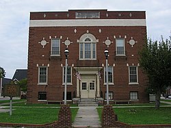
Today the main routes of access to the city are State Highways 90 and state 61. KY 90 East and KY 61 South are part of the Appalachian Development Highway System; Burkesville has the only 90-degree turn in an APD corridor, because the original route was moved west to please Tennessee Congressman Joe L. Evins and perhaps Kentucky Congressman Tim Lee Carter of Tompkinsville. An old-fashioned town square sits on Main Street, which splits and forms a circle around the Cumberland County court house, the third incarnation of the structure. The first was built by Thomas Lincoln, the father of Abraham Lincoln. Original buildings ring the square on three sides; the fourth was razed to make way for a modern justice center, completed in 2006. Two streets branch off perpendicular to Main: River Street runs straight toward the Cumberland River and provides access to the town's only public boat ramp, while Hill Street immediately begins scaling the Alpine Hill that towers over the city. This road was the only access to the city from the west for many years until Highway 90 was rerouted through a gap called the Sawmill Cut, site of a small sawmill until the road was further modernized in the 21st century. Highway 61 North was most recently modernized; the highway and park improvements were pushed by Burkesville lawyer David Williams as president of the state Senate from 2000 to 2013.

Geography

Burkesville is located at 36°47′34″N85°22′10″W / 36.79278°N 85.36944°W / 36.79278; -85.36944 (36.792787, -85.369578). [8]

According to the United States Census Bureau, the city has a total area of 2.64 square miles (6.85 km2), of which 2.57 square miles (6.65 km2) is land and 0.08 square miles (0.20 km2), or 2.90%, is water. [6]

Climate

The climate in this area is characterized by hot, humid summers and generally mild to cool winters. According to the Köppen Climate Classification system, Burkesville has a humid subtropical climate, abbreviated "Cfa" on climate maps. [9]

Demographics

Historical population
CensusPop.Note
1810 106
1840 340
1850 3698.5%
1880 434
1910 817
1920 798−2.3%
1930 88611.0%
1940 1,09223.3%
1950 1,27817.0%
1960 1,68832.1%
1970 1,7171.7%
1980 2,05119.5%
1990 1,815−11.5%
2000 1,756−3.3%
2010 1,521−13.4%
2020 1,388−8.7%
2022 (est.)1,380 [10] −0.6%
U.S. Decennial Census [11]

As of the census of 2000, [12] there were 1,756 people, 768 households, and 459 families residing in the city. The population density was 620.2 inhabitants per square mile (239.5/km2). There were 856 housing units at an average density of 302.3 per square mile (116.7/km2). The racial makeup of the city was 86.90% White, 10.88% African American, 0.17% Native American, 0.17% from other races, and 1.88% from two or more races. Hispanic or Latino of any race were 0.91% of the population.

There were 768 households, out of which 27.2% had children under the age of 18 living with them, 36.5% were married couples living together, 19.1% had a female householder with no husband present, and 40.2% were non-families. 37.0% of all households were made up of individuals, and 18.8% had someone living alone who was 65 years of age or older. The average household size was 2.15 and the average family size was 2.79.

In the city, the population was spread out, with 22.9% under the age of 18, 7.7% from 18 to 24, 23.5% from 25 to 44, 22.7% from 45 to 64, and 23.1% who were 65 years of age or older. The median age was 42 years. For every 100 females, there were 76.5 males. For every 100 females age 18 and over, there were 69.5 males.

The median income for a household in the city was $17,209, and the median income for a family was $24,028. Males had a median income of $20,985 versus $16,763 for females. The per capita income for the city was $11,653. About 23.8% of families and 29.9% of the population were below the poverty line, including 38.0% of those under age 18 and 30.4% of those age 65 or over.

Education

Burkesville has a lending library, the Cumberland County Public Library. [13]

Notable residents

Related Research Articles

<span class="mw-page-title-main">Clinton County, Kentucky</span> County in Kentucky, United States

Clinton County is a county located in the U.S. state of Kentucky in the Pennyrile Region along the southern border with Tennessee. As of the 2020 census, the population was 9,253. Its county seat is Albany. The county was formed in 1835 and named for DeWitt Clinton, the seventh Governor of New York. It is a prohibition or dry county.

<span class="mw-page-title-main">Clay County, Tennessee</span> County in Tennessee, United States

Clay County is a county in the U.S. state of Tennessee. As of the 2020 census, the population was 7,581. Its county seat and only incorporated city is Celina. Clay County is named in honor of American statesman Henry Clay, member of the United States Senate from Kentucky and United States Secretary of State in the 19th century.

<span class="mw-page-title-main">Pickett County, Tennessee</span> County in Tennessee, United States

Pickett County is a county located in the U.S. state of Tennessee. As of the 2020 census, the population was 5,001, making it the least populous county in Tennessee. Its county seat is Byrdstown. The city of Byrdstown and the Kentucky town of Albany, 11 miles (18 km) to the northeast, are positioned between two Army Corps of Engineers lakes: Dale Hollow Lake, mainly in Tennessee, and Lake Cumberland, in Kentucky. The area is known as "Twin Lakes" and Byrdstown is noted as "The Gateway To Dale Hollow Lake". Every year thousands of people vacation at the many resorts situated along the lakes.

<span class="mw-page-title-main">Russell County, Kentucky</span> County in Kentucky, United States

Russell County is a county located in the U.S. Commonwealth of Kentucky. As of the 2020 census, the population was 17,991. Its county seat is Jamestown and its largest city is Russell Springs. The county was formed on December 14, 1825, from portions of Adair, Cumberland and Wayne Counties and is named for William Russell.

<span class="mw-page-title-main">Pulaski County, Kentucky</span> County in Kentucky, United States

Pulaski County is a county in the U.S. Commonwealth of Kentucky. As of the 2020 census, the population was 65,034. Its county seat is Somerset. The county was founded in December 1798 from land given by Lincoln and Green Counties and named for Polish patriot Count Casimir Pulaski. Pulaski County comprises the Somerset, KY Micropolitan Statistical Area. Somerset's population is just over 11,000, but the Micropolitan Area for Somerset/Pulaski County is over 65,000.

<span class="mw-page-title-main">LaRue County, Kentucky</span> County in Kentucky, United States

LaRue County is a county in the central region of the U.S. state of Kentucky, outside the Bluegrass Region and larger population centers. As of the 2020 census, the population was 14,867. Its county seat is Hodgenville, which is best known as the birthplace of United States President Abraham Lincoln. The county was established on March 4, 1843, from the southeast portion of Hardin County. It was named for John P. LaRue, an early settler. LaRue County is included in the Elizabethtown-Fort Knox, KY Metropolitan Statistical Area, which is also included in the Louisville/Jefferson County-Elizabethtown-Bardstown, KY-IN Combined Statistical Area. It is a dry county.

<span class="mw-page-title-main">Cumberland County, Kentucky</span> County in Kentucky, United States

Cumberland County is a county located in the Pennyroyal Plateau region of the U.S. state of Kentucky. As of the 2020 census, the population was 5,888. Its county seat is Burkesville. The county was formed in 1798 and named for the Cumberland River, which in turn may have been named after the Duke of Cumberland or the English county of Cumberland.

<span class="mw-page-title-main">Columbia, Kentucky</span> City in Kentucky, United States

Columbia is a home rule-class city just above Russell Creek in Adair County, Kentucky, in the United States. The population was 4,452 at the 2010 census. Columbia is the seat of its county.

<span class="mw-page-title-main">Pineville, Kentucky</span> City in Kentucky, United States

Pineville is a home rule-class city in Bell County, Kentucky, United States. It is the seat of its county. The population was 1,732 as of the 2010 census. It is located on a small strip of land between the Cumberland River and Pine Mountain.

<span class="mw-page-title-main">Greensburg, Kentucky</span> City in Kentucky, United States

Greensburg is a home rule-class city in and the county seat of Green County, Kentucky, United States. The population was 2,163 at the 2010 census, down from 2,396 at the 2000 census.

<span class="mw-page-title-main">Vine Grove, Kentucky</span> City in Kentucky, United States

Vine Grove is a home rule-class city in Hardin County, Kentucky, United States. The population was 4,520 at the 2010 census, up from 4,169 at the 2000 census. It is part of the Elizabethtown–Fort Knox Metropolitan Statistical Area.

<span class="mw-page-title-main">Cumberland, Kentucky</span> City in Kentucky, United States

Cumberland is a home rule-class city in Harlan County, Kentucky, in the United States. The population according to the 2010 Census was 2,237, down from 2,611 at the 2000 census.

<span class="mw-page-title-main">Harlan, Kentucky</span> City in Kentucky, United States

Harlan is a home rule-class city in and the county seat of Harlan County, Kentucky, United States. The population was 1,745 at the 2010 census, down from 2,081 at the 2000 census.

<span class="mw-page-title-main">Hodgenville, Kentucky</span> City in Kentucky, United States

Hodgenville is a home rule-class city in LaRue County, Kentucky, United States. It is the seat of its county. Hodgenville sits along the North Fork of the Nolin River. The population was 3,206 at the 2010 census. It is included in the Elizabethtown metropolitan area.

<span class="mw-page-title-main">Vanceburg, Kentucky</span> City in Kentucky, United States

Vanceburg is a home rule-class city in Lewis County, Kentucky, United States, along the Ohio River. The population was 1,428 at the 2020 census. It is the county seat of Lewis County.

<span class="mw-page-title-main">Stearns, Kentucky</span> Census-designated place in Kentucky, United States

Stearns is an unincorporated community and census-designated place (CDP) in McCreary County, Kentucky, United States. The population was 1,365 at the 2020 census. It was founded by Justus Smith Stearns.

<span class="mw-page-title-main">Edmonton, Kentucky</span> City in Kentucky, United States

Edmonton is a home rule-class city in and the county seat of Metcalfe County, Kentucky, United States. It is part of the Glasgow Micropolitan Statistical Area. The population was 1,671 at the 2020 census.

<span class="mw-page-title-main">Springfield, Kentucky</span> City in Kentucky, United States

Springfield is a home rule-class city in and county seat of Washington County, Kentucky, United States. The population was 2,846 at the 2020 census.

<span class="mw-page-title-main">Williamsburg, Kentucky</span> City in Kentucky, United States

Williamsburg is a home rule-class city in and the county seat of Whitley County, on the southeastern border of Kentucky, United States. The population was 5,245 at the 2010 census. Developed along the Cumberland River, the city was founded in 1818 and named after William Whitley.

<span class="mw-page-title-main">Celina, Tennessee</span> City in Tennessee, United States

Celina is a city in and the county seat of Clay County, Tennessee, United States. The population was 1,495 at the 2010 census.

References

  1. "2020 U.S. Gazetteer Files". United States Census Bureau. Retrieved March 18, 2022.
  2. "Annual Estimates of the Resident Population for Incorporated Places in Kentucky: April 1, 2020 to July 1, 2022". United States Census Bureau. Retrieved May 26, 2023.
  3. "Annual Estimates of the Resident Population for Incorporated Places in Kentucky: April 1, 2020 to July 1, 2022". United States Census Bureau. Retrieved May 26, 2023.
  4. "Summary and Reference Guide to House Bill 331 City Classification Reform" (PDF). Kentucky League of Cities. Retrieved December 30, 2014.
  5. "Find a County". National Association of Counties. Archived from the original on May 31, 2011. Retrieved June 7, 2011.
  6. 1 2 "Geographic Identifiers: 2010 Demographic Profile Data (G001): Burkesville city, Kentucky". U.S. Census Bureau, American Factfinder. Archived from the original on February 12, 2020. Retrieved August 13, 2014.
  7. "Pack Horse Library". Kingsport Times. November 8, 1938. Retrieved September 3, 2017 via Newspapers.com.
  8. "US Gazetteer files: 2010, 2000, and 1990". United States Census Bureau. February 12, 2011. Retrieved April 23, 2011.
  9. Climate Summary for Burkesville, Kentucky
  10. "Annual Estimates of the Resident Population for Incorporated Places in Kentucky: April 1, 2020 to July 1, 2022". United States Census Bureau. Retrieved May 26, 2023.
  11. "Census of Population and Housing". Census.gov. Retrieved June 4, 2015.
  12. "U.S. Census website". United States Census Bureau . Retrieved January 31, 2008.
  13. "Kentucky Public Library Directory". Kentucky Department for Libraries and Archives. Archived from the original on January 11, 2019. Retrieved June 5, 2019.
  14. "Area History". Burkesville Kentucky Online. 2007 Archived October 29, 2009, at the Wayback Machine
  15. State historical plaque located in Burkesville, Kentucky Archived October 30, 2009, at the Wayback Machine