Bengal is an unincorporated community in Taylor County, Kentucky, United States. Located west of the city of Campbellsville, the county seat of Taylor County, it is served by Bengal Road from Campbellsville and by Route 323. Its elevation is 722 feet (220 m).
Dubre is an unincorporated community in Cumberland County, Kentucky, United States. It lies along Route 90 west of the city of Burkesville, the county seat of Cumberland County. Its elevation is 640 feet (195 m). Dubre had a post office, with the ZIP code of 42731. The postmaster of Dubre, Ms. Hazel Anderson Alexander, died November 18, 2010. The post office, which had been open only two hours a day was suspended by the USPS several weeks after her death, on December 3, 2010. Ms. Alexander began her tenure with the Dubre post office March 31, 1970. The Post Office was located inside of the Anderson Grocery, which also closed after Alexander's death.

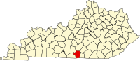
Marrowbone is a census-designated place in Cumberland County, Kentucky, United States. As of the 2010 census it had a population of 217. It has a post office, with the ZIP code of 42759.

Waterview is an unincorporated community in Cumberland County, Kentucky, United States. It lies along Route 90 west of the city of Burkesville, the county seat of Cumberland County. Its elevation is 571 feet (174 m).
Peytonsburg is an unincorporated community in Cumberland County, Kentucky, United States. It lies along Route 61 south of the city of Burkesville, the county seat of Cumberland County, and almost on the Tennessee border. Its elevation is 1,001 feet (305 m).
Kettle is an unincorporated community in Cumberland County, Kentucky, United States. It lies along Route 61 south of the city of Burkesville, the county seat of Cumberland County. Its elevation is 984 feet (300 m).
Judio is an unincorporated community in Cumberland County, Kentucky, United States. It lies along Route 953 southwest of the city of Burkesville, the county seat of Cumberland County. Its elevation is 545 feet (166 m).

Grider is an unincorporated community in Cumberland County, Kentucky, United States. It lies along Kentucky Route 90, west of the city of Burkesville, the county seat of Cumberland County. Its elevation is 617 feet (188 m).

Bow is an unincorporated community in Cumberland County, Kentucky, United States. It lies along Route 90 southeast of the city of Burkesville, the county seat of Cumberland County. Its elevation is 607 feet (185 m).
Amandaville is an unincorporated community in Cumberland County, Kentucky, United States. It lies along Route 704 north-northeast of the city of Burkesville, the county seat of Cumberland County. Its elevation is 600 feet (183 m).
Hendricks is an unincorporated community in Magoffin County, Kentucky, United States. It lies along Route 30 south of the city of Salyersville, the county seat of Magoffin County. Its elevation is 876 feet (267 m).
Sublett is an unincorporated community in Magoffin County, Kentucky, United States. It lies along Route 7 southeast of the city of Salyersville, the county seat of Magoffin County. Its elevation is 883 feet (269 m).
Swampton is an unincorporated community in Magoffin County, Kentucky, United States. It lies along Route 7 southeast of the city of Salyersville, the county seat of Magoffin County. Its elevation is 919 feet (280 m).
Wheelersburg is an unincorporated community in Magoffin County, Kentucky, United States. It lies along Route 1081 northeast of the city of Salyersville, the county seat of Magoffin County. Its elevation is 853 feet (260 m).
Wonnie is an unincorporated community in Magoffin County, Kentucky, United States. It lies along U.S. Route 460 and Kentucky Route 1081 northwest of the city of Salyersville, the county seat of Magoffin County. Its elevation is 814 feet (248 m).
Caney is an unincorporated community and coal town in Morgan County, Kentucky, United States. It lies along Route 191 south of the city of West Liberty, the county seat of Morgan County. Its elevation is 869 feet (265 m).
Lenox is an unincorporated community and coal town in Morgan County, Kentucky, United States. It lies along Route 172, northeast of the city of West Liberty, the county seat of Morgan County. Its elevation is 797 feet (243 m).
Moon is an unincorporated community in Morgan County, Kentucky, United States. It lies along Kentucky Route 172 northeast of the city of West Liberty, Kentucky, the county seat of Morgan County. Its elevation is 755 feet (230 m). The community's post office, with the ZIP code of 41457, closed in 1997.
Stacy Fork is an unincorporated community in Morgan County, Kentucky, United States. It lies along Route 191 south of the city of West Liberty, the county seat of Morgan County. Its elevation is 823 feet (251 m).
White Oak is an unincorporated community in Morgan County, Kentucky, United States. It lies along U.S. Route 460 southeast of the city of West Liberty, the county seat of Morgan County. Its elevation is 801 feet (244 m).